
Print out your own walking tour of LeDroit Park
I have led historic walking tours of LeDroit Park for five years as part of the annual WalkingTown DC event. You can download the guide I wrote and related images and walk the tour yourself. The tour starts and ends at the arch at 6th and T Streets.
- Main guide text
- Images A-M, and S (print in black and white)
- Images N-R, and T (print in color)
The tour, when spoken to a crowd, takes about 90 minutes. If you read it silently, you can finish it faster.
If you want to learn about the architectural details of LeDroit Park, e.g. what makes a house Second Empire, check out the excellent LeDroit Park Conserved, a preservation book about LeDroit Park produced for the District government in the 1970s.
Turn down that Prince music!

In 1998 LeDroit residents wrote an open letter to incoming Mayor Anthony Williams to complain about Prince and the House of Secrets (507 T Street).
Clean Up Street in LeDroit Park
We live amongst trash and filth in the 500 block of T Street NW, in the historic area of LeDroit Park. We are proud of our aged homes and the famous black Americans who lived in them. But when we turn the corner at Sixth and T streets, we are appalled at the piled garbage and trash. When we have special guests at our homes, we must hire a private company to remove the trash so that we will not be embarrassed. We also have a problem with the parties held in our neighborhood at an after-hours nightclub, the House of Secrets. It’s no secret that the last two times The Artist Formerly Known as Prince performed in the area, he had a party that went on from 1 a.m. until 5 a.m. on a Tuesday morning. The purple buses roared down our one-way street and unloaded noisy passengers. The limousines, cars and taxis pulled up, double parked and blocked our driveways. How is it that an after-hours establishment is allowed to exist in our neighborhood? We, law-abiding citizens, do not want this nightclub. We do not want to party. We want to sleep.
Lois Wiley and LilliAnn Williams, T Street NW
This letter appeared with other residents’ letters to Anthony Williams, who officially became mayor two days later. The House of Secrets has hosted parties for decades, but has been relatively quiet since 2013, when two people were stabbed outside the house during a party.
The Alcoholic Beverage Control Board investigated the incident to decide whether it should decline future temporary liquor license requests for the house. Although nightclubs and bars are not permitted in that location by zoning, the city does issue occasional temporary event licenses, usually for one specific day. Both the LeDroit Park Civic Association and ANC1B submitted letters protesting future licenses.
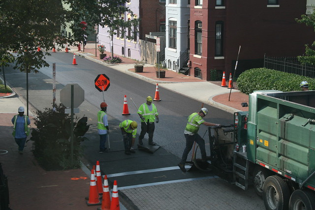
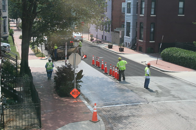
DDOT will improve T Street in early May
ANC Commissioner Brian Footer informed me that DDOT will apply a slurry seal to T Street from Second Street to Sixth Street one day from May 1 to May 6. The sealant fills cracks and slows asphalt deterioration. During the special day that DDOT applies the sealant, parking will be prohibited on T Street and driveways will be inaccessible from 8 am to 5 pm. DDOT will post notices 72 hours before the work begins.
DDOT applied the same treatment to Fifth Street back in 2013. Here are some photos of the process and the results.

Howard convening neighbors and students on conduct issues
Howard University is hosting a forum next week to discuss students’ off-campus conduct. While most students are properly behaved and cause no problems, a few students have a penchant for raucous partying and sloppy trash disposal. The meeting will be on Wednesday, October 9 at 6:30 pm at the Blackburn University Center‘s “Forum” (2397 6th Street NW – first floor to the left of the main entrance).
In addition to interested neighbors, the university has invited the Student Association leadership, campus police, the university’s community relations office, MPD, and university representatives who enforce the Student Code of Conduct.
In other news, Howard University President Sidney Ribeau announced that he will retire (a polite way to say resign) at the end of the calendar year. During Mr. Ribeau’s five-year tenure, the university suffered declining enrollment and declining revenues.
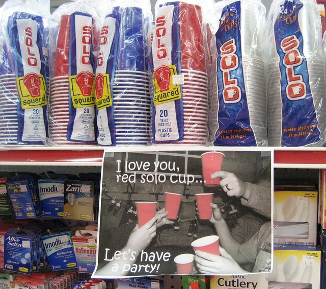
Photo credit: “Red Solo cups” by TheKarenD on Flickr
The war between the states comes to 6th & Florida

The Bohemian margarita is a specialty of Bistro Bohem.
The City Paper reports that Bistro Bohem‘s mixologist (cocktail chef), Mark Reyburn, has defected across 6th Street to Shaw’s Tavern. Reyburn intends to infuse Shaw’s menu with Civil War-era cocktails befitting the venue’s namesake.
Considering that Bohem’s cocktails were exceptionally good when I reviewed the place in May, Reyburn’s new grog gig is sure to please.
The City Paper also notes that Shaw’s plans to add a roofdeck within two months. I have come to learn, however, that these build-outs typically take longer than even the most ambitious restaurateurs expect.
But even with Shaw’s salvo of a new cocktail list and roofdeck, Bohem isn’t ready to surrender so easily. Bohem is planning a Reconstruction of its own, in fact. The Bohem dominion is expanding into the space next door that used to be Zee’s Restaurant. The new Cafe Bohem will open on September 3 and will serve coffee and pastries.
Will Florida Avenue become the next U Street?

A sign of things to come?
When perusing the excellent interactive DC zoning map, one thing stands out around LeDroit Park: all the properties fronting Florida Avenue are zoned to permit both residential and commercial uses. Even the rowhouses on the LeDroit side of Florida Avenue can be turned into restaurants, offices, or shops without any need for special zoning approval.*
We mention this not to alarm anyone, but to educate residents about the influence of zoning ordinances. Zoning is the invisible geography that quietly shapes the use and form of the built environment.

The north-side rowhouses on the 400, 500, and 600 blocks of Florida Avenue were clearly built as homes. About 100 years ago, many of these rowhouses hosted the offices of Washington’s prominent black doctors.
Neighborhoods change and businesses move and nearly all the rowhouses on our stretch of Florida Avenue reverted to their original uses as residences. Even the notable Harrison’s Cafe at 455 Florida Avenue is a residence with much of its former retail bay window bricked in.

Thai X-ing, a culinary outpost
A few businesses still dot Florida Avenue. While Shaw’s Tavern and Bistro Bohem are reviving the corner of Florida Avenue and 6th Street, they occupy buildings that are clearly commercial in form. Thai X-ing, however, has been located for several years in and old rowhouse at 515 Florida Avenue NW. Though it looks like an abberation, Thai X-ing may just be ahead of its time.
The properties fronting Florida Avenue are zoned C-2-A, which permits as a matter of right,
office employment centers, shopping centers, medium-bulk mixed use centers, and housing to a maximum lot occupancy of 60% for residential use and 100% for all other uses, a maximum FAR of 2.5 for residential use and 1.5 FAR for other permitted uses, and a maximum height of fifty (50) feet. Rear yard requirements are fifteen (15) feet; one family detached dwellings and one family semi-detached dwellings side yard requirements are eight (8) feet.
There is no need to worry about an old rowhhouse being torn down and turned into office blocks. First, the houses along the LeDroit Park side of Florida Avenue are within the historic district. Historic preservation laws prevent drastic alterations, especially alterations to such an cohesive section of architecture.
Second, the C-2-A zone is a low-density zone, permitting a floor-area ratio (FAR) of only 1.5 for non-residential uses. Most of the existing rowhouses already exceed 1.5 FAR since they were built before the current zoning code.
The opening and success of Shaw’s Tavern and Bistro Bohem demonstrate business success along our stretch of Florida Avenue. There is clearly a demand for commercial activity near LeDroit Park and we were happy to spend Sunday afternoon revisiting Bistro Bohem. Whether this demand translates into rowhouse conversions into restaurants and bars remains to be seen. Even still, don’t be surprised if Thai X-ing gets a few restaurant, pub, cafe, or boutique neighbors in the coming years.

501 Florida Avenue
* Though one may open a restaurant without special approval in a commercial zone, a restaurateur must still follow the usual process for obtaining a license to serve alcohol.
Injured driver crashes into Shaw’s Tavern
We got news this morning that a man had been found stabbed on the 500 block of Florida Avenue NW near Shaw’s Tavern. The story turned out to be a bit more complicated. A man driving a BMW crashed into the Florida Avenue side of Shaw’s Tavern early this morning. When police arrived, they found the driver with a stab wound in his neck. He was taken to Howard University Hospital where he later died.
The details are unclear at this point, but the driver may have been stabbed elsewhere and may have been trying to drive himself to the hospital for treatment.
Here’s the Fox 5 news report from early this morning.
This is not the first significant crash near 6th and Florida. In 2006, a drunk driver crashed into 605 Florida Avenue, destroying much of the house’s brick turret.
Review: Shaw’s Tavern

Restaurant review
Shaw’s Tavern
520 Florida Avenue NW
Rating: 5 arches (out of 5)
Recommendation: House-smoked pulled pork shoulder (pictured above)
Back in November 2010 we wrote about the renovation underway at the two-story brick building at the southeast corner of 6th Street and Florida Avenue. What a great place for a cafe, we opined.
Finally in July of last year, a restaurant called Shaw’s Tavern opened up in the space. Many neighbors expressed eager anticipation at the very rumor, mostly since Florida Avenue lacks a variety of decent sit-down options.
The excitement was short-lived. The restaurant’s management ran afoul of the District’s liquor regulations when it allegedly forged an alcohol license to purchase liquor from suppliers. Just before opening, Shaw’s hosted several events during which they served alcohol without the a license. The Alcohol Beverage Control (ABC) Board, rightly outraged, refused to grant the license.
Unable to serve alcohol, which is where restaurants make much of their money, Shaw’s quickly closed. New owners bought the business and have reopened the space for breakfast, brunch, and lunch. Shaw’s will finally serve dinner and thus expand their hours beyond the 4 pm closing when they get their alcohol license approved.
We dropped by Shaw’s Tavern recently to sample the food and the trip was well worth it. The food was excellent and refined and the atmosphere was pleasant.
We ordered the house-smoked pulled pork shoulder (pictured above), which is served on a patty of crispy jalapeño-cheddar polenta and cider vinegar jus. The waiter described the item as “killer” so we couldn’t possibly ignore such an endorsement.
It turns out the waiter was right. The pork, as he described, is smoked for 12 hours. It shows. The distinctly smokey and faintly tangy flavor of the tender shoulder meat makes the dish a signature item for Shaw’s.
The pork tops a polenta patty, which is cripsy like hash-browns on the exterior, but creamy like skillfully prepared scrambled eggs on the inside. In fact the filling is not egg at all, but jalapeño cheddar cheese with polenta, making it a close rival to the pork.
 For dessert we ordered spiced chocolate pudding. A dollop of cream and candied orange peel garnish the pudding. Don’t let that fool you, though. The pudding itself is not nearly as sweet as most American desserts and so the spice stands out.
The interior of the restaurant provides an unusual variety of seating options. There are high tables for four people and larger parties. The bar itself is as wide as a full table and provides ample space for dining. The outdoor patio on the 6th Street side just opened with several iron tables and chairs. The inside also sports several couches with coffee tables, each equipped with a book on the Civil War to honor the restaurant’s namesake, Col. Robert Gould Shaw, for whom the Shaw neighborhood is named.
There are few restaurants that really impress us, but Shaw’s Tavern was able to do it. When it opens up for dinner, we expect to return often.
Shaw’s Tavern
520 Florida Avenue NW
(Check their website for their hours)
Street names changed in 1890

Two years ago we wrote about the old street names for LeDroit Park. Finding out just when the name change occurred is hard to pin down. Different sources, from address directories to newspaper articles, refer to old names and new names during the same period of time.
The mystery is closer to resolution, however, as we found what we believe to be the earliest reference to the name change:
New Names for Le Droit Park Streets.
Washington Post
July 31, 1890The names of the streets in Le Droit Park have been changed as follows: Le Droit Park avenue to Second street, Harewood avenue to Third street, Linden street to Fourth street, Larch street to Fifth street, Juniper street to Sixth street, and Maple avenue to T street.
There appears to be an error in the article as ‘Le Droit avenue’ never actually had ‘Park’ in its name.
Census data for LeDroit Park
In preparation for redistricting Ward 1’s ANCs, the DC Office of Planning has released block-by-block demographic data for the District. We have combined the data for the blocks that comprise LeDroit Park to create a LeDroit Park census.
Analyzing U.S. Census data for LeDroit Park proves difficult because the of the way census tracts are drawn. Our census tract, 34, combines LeDroit Park and Howard University. Dorms on the northern end of the campus, far away from LeDroit Park, account for 717 of the tract’s 4,347 residents, thus skewing tract data. Furthermore, the tract also inclues several blocks bounded by Rhode Island Avenue NW, Florida Avenue NW, and 2nd Street NW.
Fortunately, the Census Bureau provides data for each block, allowing us to combine the statistics for those blocks in LeDroit Park, while excluding the Howard University campus. In the map below, we have outlined the tract in blue and shaded the blocks for LeDroit Park in red.
View LeDroit Park Census in a larger map
Though LeDroit Park started out as an exclusively white suburban neighborhood, by 1910 the neighborhood was almost entirely black. Today, 100 years later, the neighborhood is 70% black and is continuing to diversify.

However, when looking at the numbers on a block-by-block basis, you see that the neighborhood demography, must like that of the District itself, is unevenly distributed.
The block bounded by 5th Street, T Street, 6th Street, and U Street is 53% white, the highest in the neighborhood. Likewise, the block containing the Kelly Miller public housing is 91% black, the highest percentage in the neighborhood. The block containing the arch and the Florida Avenue Baptist Church comes closest to black-white equilibrium at 44% and 49% for each group respectively.

When looking at total population numbers for each block, you see that the two most populous blocks contain Howard University dorms. The block bounded by 2nd Street, T Street, 3rd Street, and Elm Street has 382 residents and contains Slowe Hall, which houses 299 students.
The second most populous block contains the new park. However, it also contains Carver Hall, which itself houses 173 students. Certainly these blocks are big, but the fact that their population numbers are off the chart has more to do with student dorms than with any inherent difference in housing density.

Finally, when we look at housing vacancy, we see that the block bounded by 5th Street, T Street, 6th Street and U Street has 38% of its housing units vacant. We’re not sure what’s causing this number, but we suspect that the apartment building at 5th and U Streets NW boosted the vacancy rate. The building has since been finished and is fully rented.
The block with the second-highest rate of vacancy contains the now-renovated Ledroit Place condo building at 1907 3rd Street NW.

It would be interesting too look at other data, including household income, car ownership, and age distribution for the neighborhood. However, the Office of Planning’s spreadsheet only covered population numbers, racial distribution, and housing unit numbers, so those are the metrics we graphed.


Recent Comments