
Study finds LeDroit Park’s historic designation didn’t cause displacement
Does historic district designation lead to gentrification and displacement? Christine Rae Henry, a 19-year LeDroit Park resident, recently finished her dissertation on this topic and used LeDroit Park as her case study. She found the answer is no:
The broad findings show that displacement has been happening not just since the historic district designation in 1974, but actually began in the late 1960s when single-family homes that had been converted into multi-family units were beginning to be returned to single-family use (or mostly single family with a basement unit) a result of desegregation and population shift in the city as a whole.
The dissertation is also a wonderful study of LeDroit Park’s history.
Print out your own walking tour of LeDroit Park
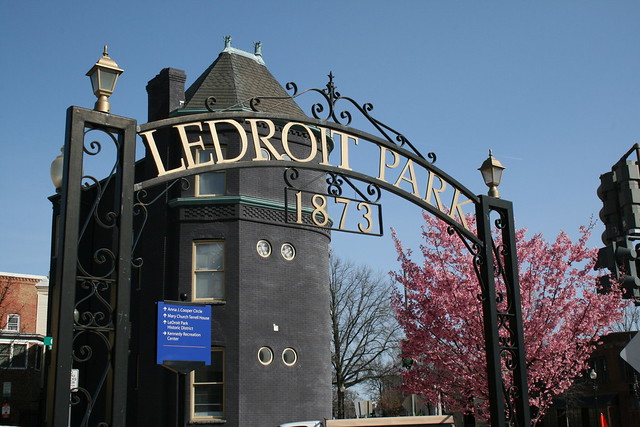
I have led historic walking tours of LeDroit Park for five years as part of the annual WalkingTown DC event. You can download the guide I wrote and related images and walk the tour yourself. The tour starts and ends at the arch at 6th and T Streets.
- Main guide text
- Images A-M, and S (print in black and white)
- Images N-R, and T (print in color)
The tour, when spoken to a crowd, takes about 90 minutes. If you read it silently, you can finish it faster.
If you want to learn about the architectural details of LeDroit Park, e.g. what makes a house Second Empire, check out the excellent LeDroit Park Conserved, a preservation book about LeDroit Park produced for the District government in the 1970s.
Two free history walking tours of LeDroit Park next month


Come on out for a free history walking tour of LeDroit Park next month. I conduct this tour annually as part of WalkingTown DC.
We will explore the unique architecture and the historical figures who transformed the neighborhood into the home of Washington’s black intelligentsia at the start of the 20th century. Neighborhood notables included Dr. Anna J. Cooper, Mayor Walter Washington, Sen. Edward Brooke, Rep. Oscar De Priest, Paul Laurence Dunbar, Mary Church Terrell, Duke Ellington, and Rev. Jesse Jackson. We will also admire the unique 19th-century houses and the 12 distinct architectural styles present in the neighborhood.
The tours will be on Sunday, September 18 at 2 pm and Sunday, September 25 at 2 pm. Meet me at the arch at 6th Street and Florida Avenue NW. The tours are free and open to the public.
Alternatively, for $15 you can attend Sarah Shoenfeld’s tour on September 11 to explore the history of housing segregation in LeDroit Park and Bloomingdale.
Explore fair housing law in LeDroit and Bloomingdale next month
 Did you know a house in Bloomingdale was the center of a landmark Supreme Court ruling on fair housing in 1948? Explore civil rights history in LeDroit Park and Bloomingdale on a walking tour next month. The tour, Mapping Segregation, will explore the history and eventual Supreme Court dismantling of de jure housing segregation.
Discover these topics on foot with historian Sarah Shoenfeld, who has extensively documented the history of racially restrictive covenants in DC.
Tour description:
In honor of the September 3 birthday of groundbreaking civil rights attorney Charles Hamilton Houston (1895-1950), historian Sarah Shoenfeld will lead a walking tour of DC’s adjacent LeDroit Park and Bloomingdale neighborhoods. Shoenfeld co-directs the online public history project Mapping Segregation in Washington DC, which shows how racially restrictive housing covenants kept much of Bloomingdale off-limits to African Americans until the 1940s. Houston, former Dean of Howard University’s law school and a NAACP attorney, waged numerous legal battles over housing in this neighborhood. One of them, Hurd v. Hodge, contributed to the Supreme Court’s landmark ruling that racial covenants were unenforceable. This tour will feature some of the houses and blocks subject to battles over covenants, and the shifting geographic lines that divided African Americans from whites in this area over the first half of the 20th century.
Tour details:
Sunday, September 11 at 10 am
Meet at the arch at 6th and T Streets NW
Price: $15 – buy tickets online from the Hill Center
Free history walking tours of LeDroit Park this month
Come on out for a free history walking tour of LeDroit Park. I conduct this tour annually as part of WalkingTown DC.
We will explore the unique architecture and the historical figures who transformed the neighborhood into the home of Washington’s black intelligentsia at the start of the 20th century. Neighborhood notables included Dr. Anna J. Cooper, Mayor Walter Washington, Sen. Edward Brooke, Rep. Oscar De Priest, Paul Laurence Dunbar, Mary Church Terrell, Duke Ellington, and Rev. Jesse Jackson. We will also admire the unique 19th-century houses and the 12 distinct architectural styles present in the neighborhood.
The tours will be on Saturday, September 19 at 1 pm and Sunday, September 27 at 1pm. Meet me at the arch at 6th Street and Florida Avenue NW. The tours are free and open to the public.
Buy a McGill house for $1.4 million
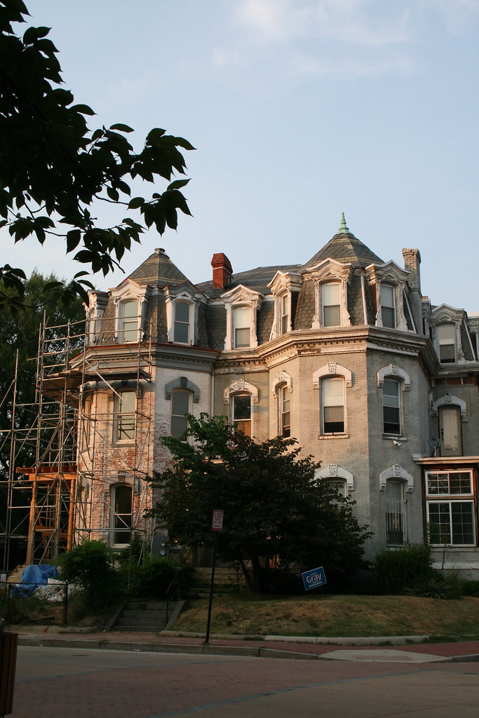
One of the original McGill houses of LeDroit Park is up for sale for $1.4 million. The Second Empire manse on Anna Cooper Circle (1901 Third St, specifically), contains seven bedrooms and 4.5 bathrooms across 3,235 sq. ft. The house is one-half of a duplex and both are pictured in the 2010 photo above (1901 is on the right).
The house’s mansard roof is a signature feature of the Second Empire style along with window moulding, ornate porches, ornate brackets, prominent eaves, and prominent cornices.
In the late 19th century, the house was the home of General William Birney, a southern abolitionist who served in the Union Army during the Civil War. After the war, Birney moved to Washington to establish a law practice. He lived in LeDroit Park for a few years and eventually retired to Montgomery County, Md.
The house previously sold for $133,636 in 1997.
WAMU reports on the new heritage trail
On Thursday the Kojo Nnamdi Show aired a program on the new LeDroit Park-Bloomingdale Heritage Trail.
Heritage Trail signs finally installed
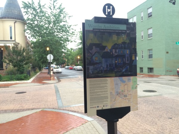
This week, after years of work, the LeDroit Park-Bloomingdale Heritage Trail is finally being installed. The signs scattered throughout both neighborhoods mark important historical sites and form a linear path history buffs can follow for a full tour of both neighborhoods.
This heritage trail is titled Worthy Ambition, a line from a Paul Laurence Dunbar poem about black achievement in spite of slavery.
Cultural Tourism DC, which researches and sponsors these trails, is partnering with the civic associations in both neighborhoods for an official unveiling. Stay tuned for details.
McMillan Fountain ready for its close-up
As part of DC Water’s construction work on the First Street Tunnel, the agency paved a temporary parking lot on the grounds of the McMillan Reservoir. Community leaders took a tour of the tunnel project on Saturday and got a close-up photo of the top of the McMillan Fountain, which stands just beyond the parking lot fence.
The base of the fountain, pictured below as it originally stood, lies dismantled in Fort Washington National Park in Prince George’s County.

Howard promises to renovate the Terrell House
 After years of neglect, Howard University has agreed to finish renovations of the Mary Church Terrell House (326 T Street NW).
Mary Church Terrell was a civil rights leader who lived from 1863 to 1954 and spent the last decades of her life in LeDroit Park. She was instrumental in lawsuit, D.C. vs. J. R. Thompson Co., Inc., that that led the U.S. Supreme Court to desegregate all restaurants in D.C. in 1953.
Mary Church Terrell and her husband Robert Terrell, D.C.’s first black judge, willed the house to their daughter and, upon her death, to Howard University, which took control of the house in 1998.
The university had long planned to renovate the house and turn into a museum focused on the Terrells and the history of the neighborhood. Those plans never came to fruition.
However, in a Feb. 26 meeting between community leaders, including me, and Howard University President Wayne Frederick, the president assured us that restoration work will start on the house within six months.
We have not seen the exact plans of the physical restoration the university will complete, but Dr. Frederick wants to revisit the concept of housing a museum as he perceives a lack of support for that specific use.
The president is well aware of the vast community support toward the house’s physical restoration. The LeDroit Park Civic Association voted in January to send a letter to the university’s leadership expressing disappointment at the state of the Mary Church Terrell House and the Walter Washington House (408-410 T Street NW), both of which are Howard properties in different state of disrepair.


Recent Comments