
JBG reveals the locations of the new retailers opening this fall
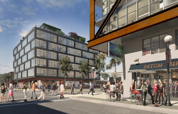
The four mixed-use buildings on Eighth Street near the 9:30 Club are about to open. The quartet is the product of prolific Washington area developer JBG, which recently released the layout of the ground-floor retail tenants. The retail spaces include small retail shops, a few restaurants, a small movie theater, and art galleries.
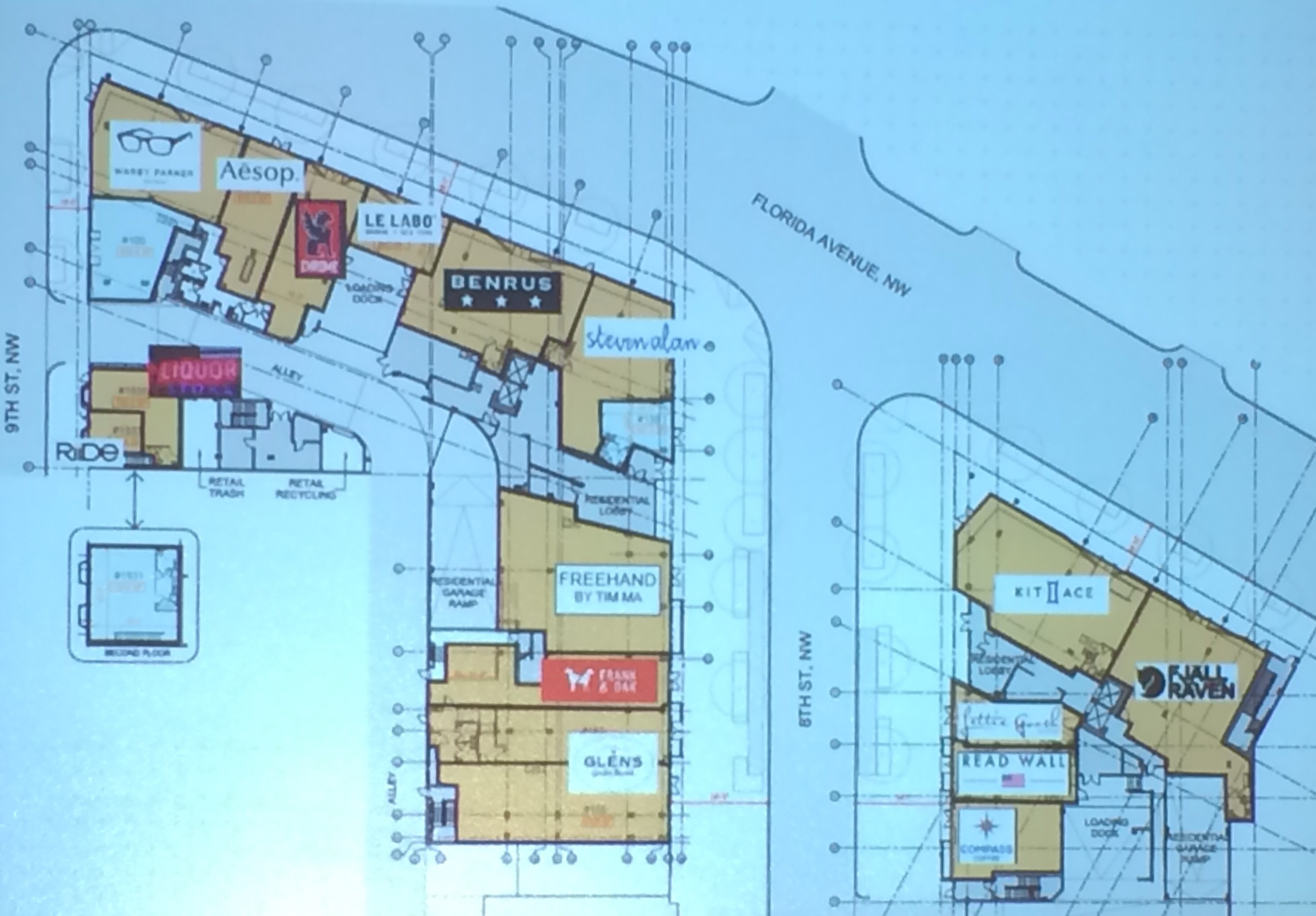
The Shay is a duo of apartments on the 700 and 800 blocks of Florida Avenue NW. Retailers include
- Riide – A DC-based electric bike company (9th Street)
- Serv U Liquors – A liquor store that previous stood on the development site (9th Street)
- Warby Parker – Purveyor of hip spectacles (9th Street & Florida Avenue)
- Aesop – An Australian retailer of sustainable skincare, haircare and other personal care products (800 b/o Florida Avenue)
- Chrome – A San Francisco-based bike bag purveyor (800 b/o Florida Avenue)
- Le Labo – A French perfumery (800 b/o Florida Avenue)
- Benrus – A Rhode Island-based clothing retailer (800 b/o Florida Avenue)
- Steven Alan – Casual clothing for men and women (8th Street & Florida Avenue)
- An unnamed restaurant from Tim Ma, owner of Water & Wall in Arlington and Maple Ave. in Vienna (8th Street)
- Frank & Oak – A hip, Montréal-based men’s clothing retailer (8th Street)
- Glen’s Garden Market – The second location of this DC-based grocer will also serve beer. (8th Street)
- Compass Coffee – The second location for the coffee shop that currently operates on 7th Street in Shaw (8th Street)
- Read Wall – DC-based menswear retailer selling knits, outerwear, custom suits, and neckware (8th Street)
- Lettie Gooch – A clothing boutique moving from U Street (8th Street)
- Kit and Ace – A retailer selling clothes made of a sturdier cashmere (8th Street & Florida Avenue)
JBG is still actively leasing three retail bays. The Shay’s grand opening is today from 6 pm to 9 pm.
Just north on Eighth Street at V Street, JBG has sold numerous condos at 2030 8th Street and has nearly completed the larger Atlantic Plumbing apartments on the north side of V Street. The company has released the retail layout of both buildings.
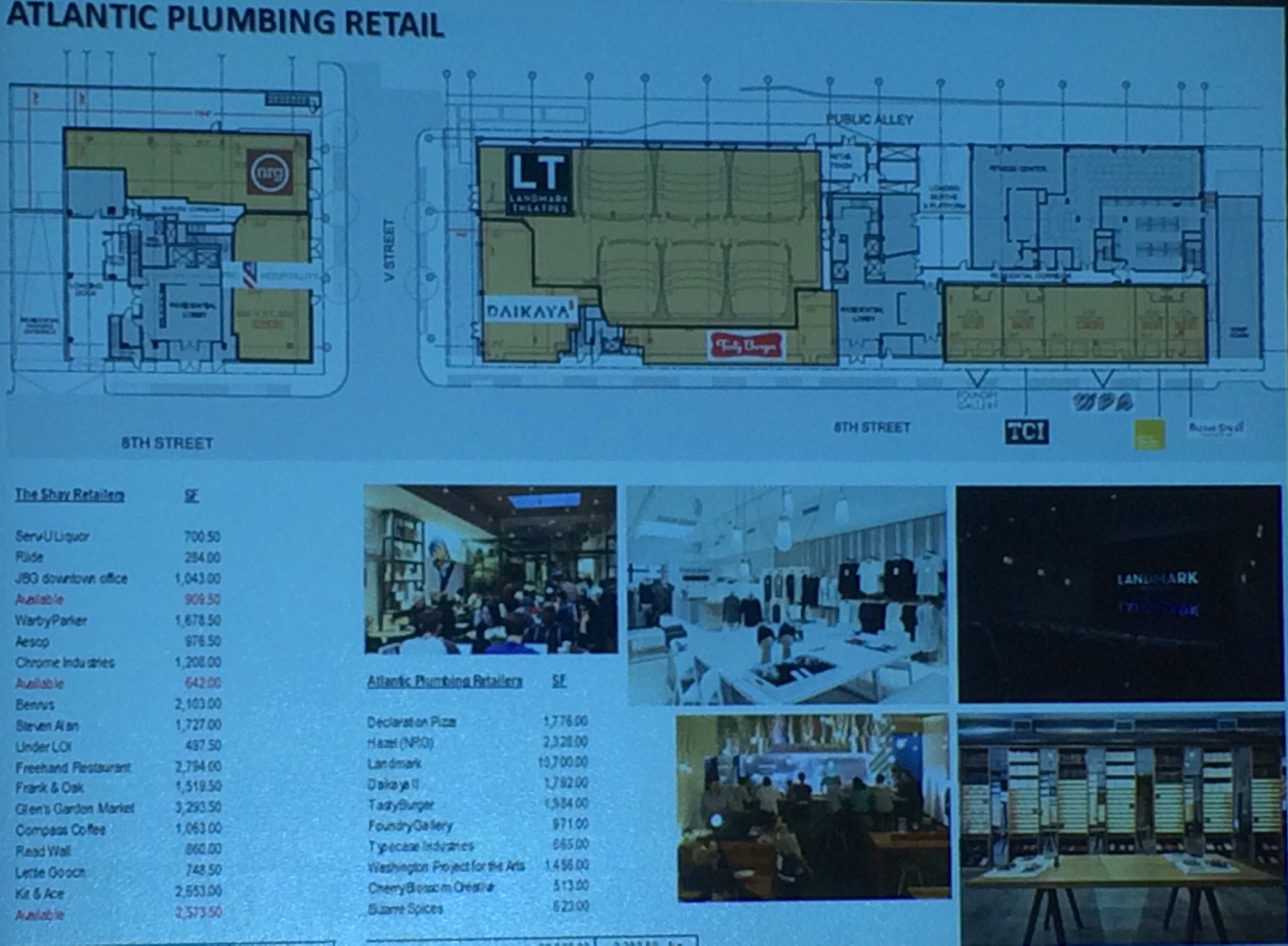
The retailers include
- Hazel (probably) – A new restaurant from Neighborhood Restaurant Group, which currently owns Birch & Barley and Bluejacket (V Street)
- Declaration Pizza – A new pizza shop from the owners of Lincoln and Teddy & the Bully Bar (8th & V Streets)
- Landmark Theatre – A theater featuring independent films in six small-screen mini-theaters (V Street)
- An unnamed ramen restaurant from the people behind Daikaya in Chinatown (8th & V Streets)
- Tasty Burger – The first DC-area location of this Boston-based burger chain (8th Street)
- Bazaar Spices – The second location for this independently owned herbs and spice shop, which also sells at Union Market (8th Street)
- Cherry Blossom Creative – A graphic-design studio that will also offer original works for retail purchase (8th Street)
- Foundry Gallery – An artist-run gallery that will move from Dupont Circle (8th Street)
- Typecase Industries – A locally-based letterpress and design studio (8th Street)
- Washington Project for the Arts – The headquarters for a non-profit arts support organization (8th Street)
All shops will be open by the end of the year.
1925 photo of Griffith Stadium also shows LeDroit Park
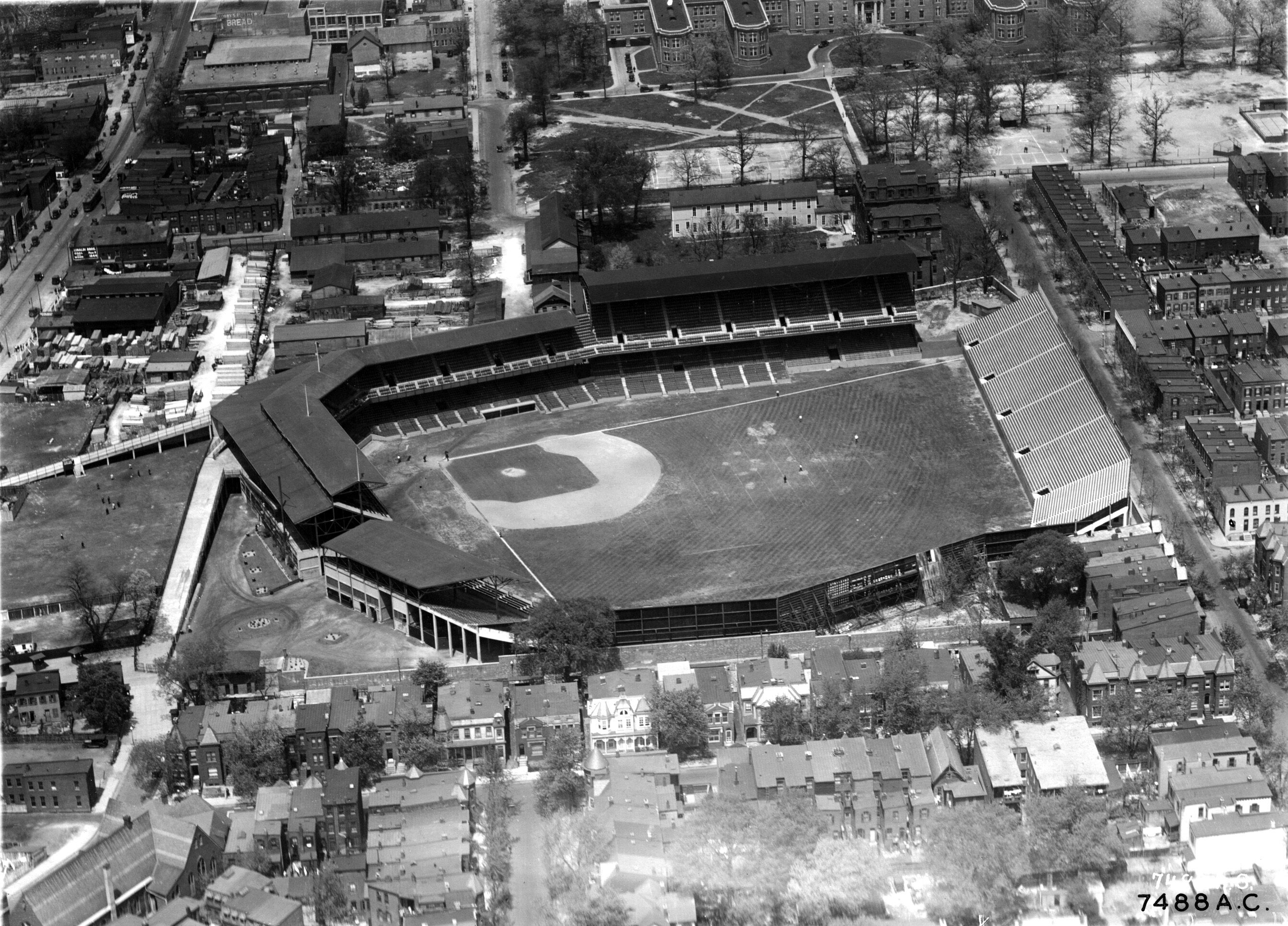
Every time I come across a photo of Griffith Stadium, which stood where Howard University Hospital now stands, I look carefully for an angle of LeDroit Park. By way of Ghosts of DC comes this superb 1925 aerial shot looking north at the stadium and part of the neighborhood.
The east-west street in the foreground is the 500 and 600 blocks of U Street NW. Zoom in and look around. Notice the streetcars on Georgia Avenue in the upper-left corner of the photo. Notice the previous incarnation of the Florida Avenue Baptist Church in the lower-left corner.
The stands beyond Griffith’s straightaway center field backed up to 5th Street from Elm to V Streets. Can you imagine hearing the crack of a bat and roar of crowds during a Senators game?
Also note what’s no longer standing. All but seven houses pictured east and north of the stadium have since been demolished, replaced with parking garages, parking lots, public housing, or academic buildings. Nearly all of these houses would be illegal to rebuild today under our 1950s zoning code, which mandates minimum lot sizes and house widths to which much of historic LeDroit Park does not conform.
Photo source: National Archives
New movie theaters are planned near LeDroit Park
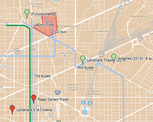
Two— possibly three— new movie theaters are set to open within a mile of LeDroit Park by 2016. All will be located within a block or two of Florida Avenue and are easily accessible by foot, bike, and 90s bus.
Atlantic Plumbing site – 800 V Street NW- unknown screens
Prolific developer JBG is starting construction on its Atlantic Plumbing project by the 9:30 Club. The project includes two mixed-use buildings on 8th Street NW, each on opposing sides of V Street. The northern building was supposed to include an 11,000-square-foot movie theater, but a September article in the WBJ makes no mention of a theater. The building will probably open in 2015.
Landmark Theater – New York Avenue & N Street NE- 10 screens
Capitol Point, another JBG mixed-use project, is located on New York Avenue NE near the maddening intersection with Florida Avenue NE. The mixed-use project is slated to receive a 10-screen Landmark Theater showing foreign and independent films. The chain currently has a location downtown on E Street and one in Bethesda. This new theater is scheduled to open in 2016.
Angelika Film Center – Union Market (5th Street & Neal Place NE) – 8 screens
Soon after you pass under the railroad tracks on Florida Avenue NE, Union Market appears embedded in the background on the left. These blocks constitute a wholesale food market that is slowly being redeveloped. The new Union Market building has met great success, featuring produce, prepared foods, oysters, meats, and dairy products along with chairs and tables for the impatient. The market fare is definitely upscale and vendors never shy from the word ‘artisanal’.
The market building’s developer announced it will open an 8-screen Angelika movie theater on an adjacent lot. Angelika theaters feature foreign and independent films and, as the Post described it, “culinary offerings from former Food Network executives.” The developer expects the theater to open in 2015.
Are we over-theatered?
Another movie theater is coming to different part of the District. In the Navy Yard, developer Forest City is planning an upscale 16-screen theater near Nationals Stadium and the Navy Yard Metro. The theater, at N Place and the future 1½ Street SE (a terrible name for a street), may not open until 2016 or later.
Can’t wait until 2015? There are four existing theaters within a 2.5-mile radius of LeDroit Park as the crow flies. The Landmark E Street Cinema (1100 block of E Street NW) and the Regal Gallery Place (7th & G Streets NW) are easily accessible from the Green Line, Yellow Line, and 70s buses. To the west of us, the West End Cinema (23rd & M Streets NW) and the AMC Loews Georgetown (3111 K Street NW) are easily accessible from the G2 bus, whose eastern terminus is LeDroit Park.
| Theater | Screens | Location | Opening | Distance |
|---|---|---|---|---|
| Atlantic Plumbing (??) | ? | 8th & V Sts NW | 2015? | 0.5 mi |
| Landmark – Capitol Point | 10 | New York Ave & N St NE | 2016 | 0.8 mi |
| Angelika Film Ctr. – Union Mkt. | 8 | 5th St & Neal Pl NE | 2015 | 1.3 mi |
| Regal Gallery Place | 14 | 7th & G Sts NW | open | 1.4 mi |
| Landmark E Street Cinema | 8 | 1100 b/o E St NW | open | 1.8 mi |
| West End Cinema | 3 | 23rd & M Sts NW | open | 2.1 mi |
| AMC Loews Georgetown | 14 | 3111 K St NW | open | 2.9 mi |
| Showplace Icon Theater | 16 | 1½ St & N Pl SE | 2016 | 3.3 mi |
Trader Joe’s coming to 14th & U

It looks like 2013 will be a harvest year for LeDroit Park residents as two new grocery stores open nearby. DCist broke the news that Trader Joe’s will open a store at the Louis building now under construction at the southwest corner of 14th and U.
Located at just under a mile’s walk from Anna J. Cooper Circle, the new store will provide another grocery option to area residents.
TJ’s prices are competitive with many other stores and the TJ’s specializes in unusual and somewhat exotic foods in addition to the usual staples. TJ’s main weakness lies in its produce selection, which, judging from experiences at the Trader Joe’s in the West End, is limited.
The store’s opening next year will also be accompanied by the opening of the 60,000 square-foot Giant at the CityMarket project at 7th and P Streets in Shaw. Once these two projects open, all the major grocery store chains in the area will be located no more than 1.1 mi. from LeDroit Park.
| Store | Location | Distance (mi) |
|---|---|---|
| Giant (opening 2013) | 7th & P Streets NW | 0.6 |
| Trader Joe’s (opening 2013) | 14th & U Streets NW | 0.9 |
| Safeway | 5th & L Streets NW | 0.9 |
| Harris Teeter | 1st & M Streets NE | 1.0 |
| Whole Foods | 1400 blk. P Street NW | 1.1 |
Even still I dream of a full-service grocery store opening up at the long-stalled Howard Town Center project at Georgia Avenue and V Street. The project, in the planning stages for many years, has been perpetually delayed by disagreements between Howard University and its development partner.
The UPO building on Rhode Island Avenue used to be a Safeway many years ago. The site is large enough to be redeveloped into a modern, urban grocery store if parking is placed underground. In fact the second floor could house UPO’s offices.
Until those dreams come true, the nearest full-service grocery stores are a long, but manageable walk.
Battle ensues over control of Crispus Attucks Park

Crispus Attucks Park by rockcreek, on Flickr
The Post is running an article about the battle over control of Crispus Attucks Park in Bloomingdale. The park is a hidden gem in Bloomingdale. It’s embedded in the middle of the block bounded by North Capitol Street, U Street NW, V Street NW, and First Street NW.
The park is on land once owned by C & P Telephone, but which was transferred to a non-profit in the 1970s. But who controls the non-profit that controls the park? Aye, there’s the rub.
Before the park, before the school, there were apartments

The Park at LeDroit was built on the site of the Gage-Eckington School. The school, built in the 1970s, was itself built over streets, houses and apartment buildings.
At the time, 3rd Street extended north of Elm Street and dead-ended just before reaching V Street. Oakdale Place extended eastward from its current terminus at the park to dead-end at what is now the eastern boundary of the park.
Two apartment buildings on the site, the Linden and the Harewood were named after local streets. Before the city changed the neighborhood’s street names, 3rd Street was Harewood Avenue and 4th Street was Linden Street.
We found this 1901 description of the apartments. What’s most notable is that the apartments are marketed to black Washingtonians and thus reflects the neighborhood’s turn-of-the-century transition from a white neighborhood to a black neighborhood.
THE LINDEN AND HAREWOOD FLATS
Le Droit Park—Corner of Harewood and Oak Streets.
The Colored American
January 5, 1901Mr. Banes the the real estate dealer has erected two of the most modern flats in Washington situated in Le Droit Park. The situation of these flats is an ideal one, on Third street, two doors from the Fourt street car line. The finish of the flats is elegant, and they have a preposessing appearance. They are three stories high, and each floor has three flats of four rooms each and bath. The whole flat is heated by steam, thus saving the necessary expense of buying fuel. Each flat has a parlor, dinning [sic] room, bed room, kitchen, and bath room and private hall rooms, and halls are heated by steam. The kitchens have a modern gas range, hot and cold water, cupboards, pantry attachment. These flats are no doubt, the best in the city. Persons having a large family can easily rent two adjoining flats saving the enormous rent of an entire house. They are thoroughly and artistically finished. The walls are papered and frescoed, and glasses of a large size, supported by a modern mantel piece are in each parlor. Le Droit Park has become a pleasant part of Washington in which to reside and these beautiful flats are a happy addition to the residences there. Mr. Banes has spared no pains in making these flats comfortable and inviting and already applications are being made for retals thereof. Colored people with first class reference who desire a beautiful part of the city in which to live, and at the same time occupy comfortable and improved apartments without renting a whole house, and paying high rent, can find a happy medium in these flats. The terms are easy. The buildings are open daily for inspection. For further information call at the office of Mr. Charles E. Banes, corner of 14th and G sts. n. w.
How LeDroit Park Came to be Added to the City
The following is a Washington Times article from 1903. The article explains some of the early history of the neighborhood and even includes three photos, the first of which was misidentified as Fifth Street, though we have actually matched it up with Second Street. We have included a few links to related information.

Second Street opposite the Anna J. Cooper House.
HOW LE DROIT PARK CAME TO BE ADDED TO THE CITY
Washington Times
Sunday, May 31, 1903For Many Years the Section of Washington Known by That Name Had Practically Its Separate Government and Had All the Characteristics of a Country Town, Although Plainly Within the Boundary Limits. * * *
In that portion of Florida Avenue between Seventh Street and Eighth Streets northwest where the street cars of the Seventh Street line and the Ninth Street line pass over the same tracks, thousands of passengers are carried every day, and probably but a few if any realize the fact that they are passing over a road older than the organization of the city, a road that dates back to the Revolutionary period— the Bladensburg Road, which connected Georgetown with Bladensburg before the location of the National Capital was determined.
The Map on the Wall.
If the people passing this point will note the little frame building occupied by a florist, 713 Florida Avenue northwest, they will observe that in front of these premises and fastened to the blacksmith shop adjoining is a goodly sized signboard on which is painted an old map of this section and showing the intersection of the old Blandensburg Road and Boundary Street, now known as Florida Avenue. From this map it is seen that Seventh Street Road [now Georgia Avenue] intersects Boundary Street and the old Bladensburg Road at a point about 100 feet east of where the two roads join at an acute angle, and glancing along the lines of Boundary Street and the north lines of some buildings which have been erected in this angle we easily see the direction of the Bladensburg Road and discover that the small building 713 Florida Avenue northwest marks the spot where the Bladensburg Road deflected from Boundary Street and bore off in a northeasterly direction toward Bladensburg.
Once Part of Jamaica Vacancy.
The map referred to is said to be a portion of [the estate named] Jamaica and and Smith’s Vacancy, but if we examine the plats in the office of the Surveyor of the District we will hardly find on file any plats of those sections, but may learn that Le Droit Park was once part of Jamaica and Smith’s Vacancy and possibly a portion of [the estate named] Port Royal. Prior to the cession of the territory now included in the District from Maryland the land known as Jamaica was owned by one Philip R. Fendall, of Virginia. He conveyed this tract of 494 acres on the 12th day of January, 1792, to Samuel Blodgett, jr., of Massachusetts, and from this point the title of the land can be traced down to the present time.
The names attached to the different vacancies establish the names of the various owners of lands adjoining Bladensburg Road at the time it was abandoned as a thoroughfare and taken up as a portion of the farms in that section, and the presence of this old road accounts for some of the peculiar lines in some of the northern boundaries of some of the lots in Le Droit Park. This road crossed Second Street at a point north of Elm Street here. The old plats show Moore’s Vacancy. The road finally joined the present road to Bladensburg at a point where the sixth milestone of the norther line of the District was located.
It is probable that this peculiarly natural boundary of some of the lands which afterward became Le Droit Park may have had something to do with the strange lines which are found in the streets of that suburb, although it was not the intention at the time that Le Droit Park was subdivided to have the streets conform with the city streets.
Site of Campbell Hospital.
During the civil war the territory now contained in Le Droit Park was used as the site of Campbell General Hospital, one of the important hospitals near Washington. The hospital comprised some seventeen separate wooden buildings, erected in the form of a hollow square, with the central portion divided into irregular spaces by buildings cutting across the inclosure and connecting the outside buildings.
The larger dimension of this hospital was fro north to south, and extended from Boundary Street, now known as Florida Avenue, on the south, to the land occupied for many years as a baseball park, situated south of Freedman’s Hospital, and designated on some of the old maps as Levi Park. From east to west the hospital covered the ground from Seventh Street to what is now known as Fifth Street in Le Droit Park, and it is possible that a portion of the space between Fifth Street and Fourth Street was also included in the hospital inclosure.

The McClelland Residence.
At this time there were only two dwellings in the tract known afterward as Le Droit Park— the McClelland and Gilman homestands. Each included about ten acres of land used for grazing and garden purposes. The McClelland property and the Gilman property were divided by a row of large oak trees which were situated about fifty feet apart and continued from Florida Avenue, then Boundary Street, to the northern line of the park.
[See the following 1861 map, a map we extolled several months ago:

]
To the east of the Gilman tract was a narrow strip of land known as the Prather tract. East of this was Moore’s Lane, now Second Street, and still to the east was the tracts of the Moores, George and David, covering the territory as far east as the present location of Lincoln Avenue [now Lincoln Road], on which was located Harewood Hospital, another hospital of considerable note during the civil war.
T.R. Senior, who was commissary at Campbell Hospital, returned to the city some twelve years after the war closed and purchased a residence at the corner of Elm and Second Streets, where he now resides. Members of the family of David McClelland now occupy the old homestead on Second Street.
Following the close of the war it became necessary to provide for such of the freedmen as were in need of assistance. Campbell General Hospital was occupied by the freedmen until August 16, 1869, when the patients were transferred to the new Freedman’s Hospital, which has been erected in connection with Howard University.
The property upon which Freedman’s Hospital stands consisted of a tract of 150 acres and was purchased from John A. Smith. In April, 1867, Howardtown was laid out and soon after some 500 lots were sold, and at this time it seems that the idea was conveyed that streets would be opened to the south through the Miller tract. In April, 1870, the Howard University purchased the Miller tract, and laid out streets to connect the streets of Howardtown with the city streets, and a little later built four houses on the line of what is now known as Fourth Street and in 1872 subdivided the Miller tract, but for some reason the plat was not recorded.
In 1873 the Miller tract was sold by Howard University to A[ndrew] Langdon, and a short time afterward A[mzi] L[orenzo] Barber, formerly secretary of Howard University, became associated with Langdon and hs partner, and by arrangements with D[avid] McClelland, all of the three tracts known as the Miller tract, the McClelland tract, and the Gilman tract were united and subdivided, and in June, 1873, a subdivision known as Le Droit Park was placed on record in the surveyor’s office. A subsequent plat was filed some eighteen months later, in which the proprietors of the subdivision declared it to be their purpose and intention to retain and control the ownership of all the streets platted, and the right to inclose the whole or any portion of the tracts or tract included in the subdivision and to locate and control all entrances and gates to the same.

During the autumn of 1876 A. L. Barber & Co. commenced the erection of fences across the north line of Le Droit Park, and from this time until August, 1891, fences were maintained along the northern line of the park. From 1886 to 1891 frequent fence wars were in operation. The fence across what is now Fourth Street would be removed by one party, and the opposing party would secure an injunction and restore it. This mode of procedure was repeated at various times until in 1901 a compromise verdict was agreed upon by the two factions and the fence was removed, Fourth Street was improved north of the park, and the streets of the park passed into the control of the city after a period of some eighteen years of private ownership.
The organization of Le Droit Park, under the limitations of the plat filed in 1873, was a peculiar experiment, that of the founding of an independent suburb adjoining the city. the southern line of the park was inclosed with a handsome combination iron and wood fence, some of which may now be found on the southern line of the McClelland property. Buildings were erected with plenty of room around them, and during the period from 1873 to 1885 the larger part of the buildings were planned and erected by James H. McGill. Double houses were quite common, but it was not until 1888 that such a thing as a row of houses were known in the park.
Before control of the streets was surrendered to the city the conditions existing in the park resembled closely those found in small country towns. Many of the inhabitants owned cows, which were pastured upon the vacant lots; the women “went a-neighboring,” and the social life savored strongly of a village, and yet it was near the city. The express and telegraph messengers, however, always collected of residents an extra fee for the reason that they lived out of the city.
With the opening of the streets and the introduction of street cars the park soon lost its former characteristics and became part of the city with all of its advantages and disadvantages. The opening of Rhode Island Avenue [from Florida Avenue eastward] spoiled in a measure the former beauty of the McClelland and Gilman homesteads, although there is still much more ground remaining in both of these old tracts that many people would care to own. The opening of Fifth Street will, to some extent, divide the traffic which now finds a way through Fourth Street. Sixth Street ends at Spruce Street [now U Street], and further progress seems barred by the residence, 601 Spruce Street, and there seems no immediate chance of the extension of Third Street above its present limit [at V Street??], where progress is barred by a high fence decorated with the advertisement of a prominent firm.
Former Familiar Street Names.
The old names of the streets of the park, such as Harewood Avenue [now Third Street], Maple Avenue [now U Street], Moore’s Lane [later Le Droit Avenue, then Second Street], Linden Street [now Fourth Street], Larch Street [now Fifth Street], Juniper Street [now Sixth Street], and Bohrer Street [still extant], are nearly forgotten, and have passed away with the fence and its period. The names of the city streets have taken their places, and with the growth of the population the country life and country scenes have given way to those of the city.
U Street Booze Moratorium

At last night’s monthly meeting of ANC1B, Councilmember Jim Graham (D – Ward 1) suggested that the neighborhood could “benefit from discussion” of a liquor license moratorium on U Street. While the U Street corridor has experienced significant growth in the number of restaurants and bars over the past ten years, not everyone is happy with the revival. The bar scene, in the midst of a dense neighborhood is bound to create conflict especially as the corridor becomes a regional destination for bar-goers.
In fact one of the attractive features of U Street is that its bars have not become as raucous and overcrowded as those in Adams-Morgan. Part of the reason is that U Street attracts a different crowd (read: fewer college students) and includes more restaurants than actual bars. Furthermore, U Street stretches 0.8 miles (from Ninth to Seventeenth Streets) compared to Adams-Morgan’s 0.4 mi (along Eighteenth Street from U Street to Columbia Road). In reality the main bar strip of Adams-Morgan is packed into the 0.2 miles between Kalorama and Columbia Roads. That’s only one-fourth the length of the U Street corridor.

We know Adams-Morgan and U Street is no Adams-Morgan.
A moratorium on U Street would freeze the supply of available bar and restaurant space without alleviating the demand. In other words, a moratorium would eventually pack the existing venues. Customers will be stuck with the same selection of venues and would suffer higher prices and larger crowds at each venue.
Furthermore, we argue that this issue is already being addressed through two other avenues. First, the ANC is careful to review liquor licenses and doesn’t hesitate to strongarm restaurateurs and barkeeps into so-called “voluntary agreements” that stipulate a variety of restrictions. These restrictions aim to maintain the livability triumvirate of “peace, order, and quiet” so that neighbors can sleep without a cacophony of throbbing music, boisterous drunks, and gun shots. The process is not perfect, but neighbors are legally entitled to input and negotiation.
Second, the liquor issue is already being addressed by proxy of the zoning code. As we reported before, no more than 25% (soon to be raised to 50%) of street frontage along Fourteenth Street and U Street within the Uptown Arts Overlay zone can be devoted to food establishments. Since restaurants make much of their money by serving alcohol, the raising of the cap to 50%, an increase with significant, though not universal, community support, implies the acceptability of a commensurate increase in liquor licenses.
* * *
In other news, the ANC voted unanimously to approve the renewal of Class C restaurant liquor licenses for the following businesses:
- Shashemene Ethiopian Restaurant – 1909 Ninth Street NW
- Ambassador Restaurant – 1907 Ninth Street NW
- Zula Restaurant – 1933 Ninth Street NW
- Sala Thai – 1301 U Street NW
- Vinoteca – 1940 Eleventh Street NW
- Red Lounge – 2013 Fourteenth Street NW
- Gori Café – 1119 V Street NW
- La Carbonara – 1926 Ninth Street NW
- El Sol de America – 1930 Ninth Street NW
- Salina Restaurant – 1936 Ninth Street NW
- Chix – 2019 Eleventh Street NW
- Masa14 – 1825 Fourteenth Street NW (rooftop license modifications are a separate matter)
- Source – 1835 Fourteenth Street NW
- Prince Hall Freemason & Eastern Star Charitable Foundation – 1000 U Street NW
- Islander Caribbean Restaurant & Lounge – 1201 U Street NW
- The Saloon – 1205-1207 U Street NW
- Ulah Bistro – 1214 U Street NW
- Lincoln Theater – 1215 U Street NW
- Café Nema-Momo’s – 1334 U Street NW
- Dynasty Ethiopian Restaurant – 2210 Fourteenth Street NW
The ANC voted to withdraw its protest and enter into a voluntary agreement with Mesobe Restaurant (1853 Seventh Street NW). The commissioners voted to protest the renewal of Expo Restaurant and Nightclub (1928 Ninth Street NW) on account of noise and trash. They aim to draft a voluntary agreement with Expo. The commission decided to take no action on the renewal of licenses for Yegna (1920 Ninth Street NW) and Eatonville (2121 Fourteenth Street NW).
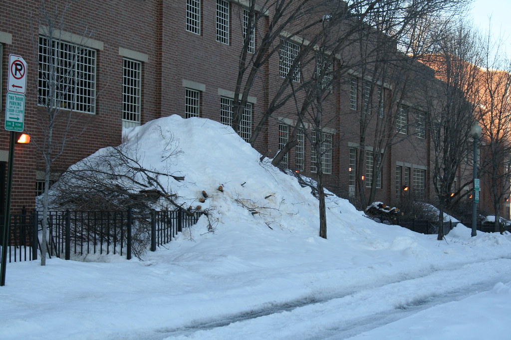
Snow Mound
Unlike Metro, Howard University Hospital must stay open no matter the weather. As such the groundskeepers are quick to remove snow the moment the first flake hits the ground. The employee parking garage on the block bounded by Fourth Street, V Street, Fifth Street, and Oakdale Place also needs its top level cleared of snow. But where does the snow from the top level go? Well, over the edge it seems.
Flashback 1958: Florida Avenue & V Street
DDOT’s historical photo archive contains this photo taken at Florida Avenue, Ninth Street, and V Street in 1958.
")
Here is the same view today.
")
Today one of the gas stations is gone, but several high-rises dot the skyline.


Recent Comments