
Neighborhood happy hour on Sep. 8, block party on Sep. 12
The LeDroit Park Civic Association has organized some social events for everyone to attend.
The next neighborhood happy hour will be on Tuesday, September 8 from 6:30 pm to 8 pm at BKK Cookshop (1700 New Jersey Ave NW). BKK, named for Bangkok’s airport code, is located in the former Beau Thai space, which recently decamped for 7th Street in Shaw.
The Civic Association will also host a neighborhood block party on Saturday, September 12th from noon to 6 pm. The party will be held on the 300 block of U Street. Everyone is welcome to attend and bring additional food.
What does LeDroit Park look like from a drone?
Over a year ago someone launched a drone from the roof of the Progression Place apartments on 7th Street by the Shaw Metro. The drone recorded high-definition video footage of the LeDroit Park, Shaw, and U Street neighborhoods.
Before you go launching your own drone, remember that they’re illegal in DC’s airspace!
Shaw Giant reopens Nov. 22
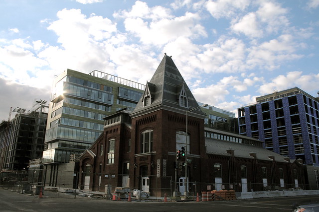
In 16 days the Giant at 7th & O Streets in Shaw will reopen after closing for redevelopment in 2011. The new store occupies 78,000 square feet, making it the largest grocery store in the District, and the closest grocery store to LeDroit Park.
Unlike the previous Giant, which was situated with its back to 9th Street, the new Giant will occupy the former historic market building along 7th Street. LeDroit residents can easily access the Giant by foot, bike, or the G2 bus, which runs along the north side of the store along P Street on its way between Georgetown and LeDroit Park.
The store is part of a larger development, City Market at O, which includes 182 hotel rooms, 407 market-rate apartments, and 90 affordable apartments for seniors.
Giant isn’t the only store opening soon. The new Trader Joe’s at 14th & U Streets is set to open early next year.
| Store | Location | Distance (mi) |
|---|---|---|
| Giant (opens Nov. 22, 2013) | 7th & O Streets NW | 0.6 |
| Trader Joe’s (opens early 2014) | 14th & U Streets NW | 0.9 |
| Safeway | 5th & L Streets NW | 0.9 |
| Harris Teeter | 1st & M Streets NE | 1.0 |
| Whole Foods | 1400 blk. P Street NW | 1.1 |

Please let the pumpkins be
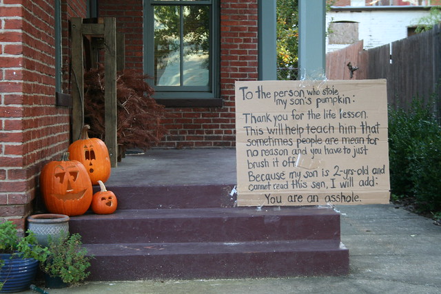
Someone snatched a pumpkin from a porch on the 400 block of U Street. The resident is not happy and left this sign:
To the person who stole my son’s pumpkin:
Thank you for the life lesson. This will teach him that sometimes people are mean for no reason and you have to just brush it off.
Because my son is 2-yrs-old and cannot read this sign, I will add:
You are an a‐‐‐‐‐‐‐.
Get a free history tour of LeDroit Park on Oct. 5 & 6

How was LeDroit Park established and who built all those unique homes on U Street? Why did the neighborhood start as exclusively white but become important to black history? As part of the annual WalkingTown DC event, I will lead two free walking tours of the neighborhood.
The tours will be on Saturday, October 5 at 1 pm and again on Sunday, October 6 at 10 am. Meet me at the arch at 6th Street and Florida Avenue NW. The tours are free and open to the public.
We’ll cover
- The neighborhood’s founding
- Relationship with the Howard Theatre
- Architectural history
- The Park at LeDroit
- Walter Washington
- Ernest Everett Just
- Robert & Mary Church Terrell
- Anna Julia Cooper
- William Birney
- Edward Brooke
- Octavius Williams
- Oscar De Priest
- Griffith Stadium
Get a free history tour of LeDroit Park on Sept. 30
How was LeDroit Park established and who built all those unique homes on U Street? Why did the neighborhood start as exclusively white but become so important to black history? As part of the annual WalkingTown DC event, I will lead two free walking tours of the neighborhood.
The tours will be on Sunday, September 30 at 1 pm and again at 3:30 pm. Meet me at the arch at 6th Street and Florida Avenue NW. The tours are free and open to the public.
We’ll cover
- The neighborhood’s founding
- Relationship with the Howard Theatre
- Architectural history
- The Park at LeDroit
- Walter Washington
- Ernest Everett Just
- Robert & Mary Church Terrell
- Anna Julia Cooper
- William Birney
- Edward Brooke
- Octavius Williams
- Oscar De Priest
- Griffith Stadium
August 8 – LeDroit Park Happy Hour

Photo by M.V. Jantzen on Flickr
It’s that time again! Come for drinks, free appetizers, and chat with your neighbors Monday, August 6 from 6 to 8 at Nellie’s (9th & U Streets NW). Nellie’s owner, a LeDroit Park resident, has kindly donated appetizers for the event.
Your favorite neighborhood blogger will be there, too!
Video: Bloomingdalers upset about recurring flooding
Channel 4 has a short segment on Tuesday night’s flooding in Bloomingdale and LeDroit Park. The Post also has a story describing the sewage-drenched nightmare that struck many residents’ basements.
DC Water, which is responsible for the water pipes and sewers, left the following note in the comments section of yesterday’s post on the flooding:
Neighbors,
We’ve received a number of phone calls, tweets and email inquiries from Bloomingdale, LeDroit and Eckington customers who faced flooding last night. We’re so sorry to hear this has happened, and want to provide some background information as well as next steps.
The sewer system under this part of the District was installed generations ago by the federal government. At the time, populations were smaller, rains were likely lighter, and people weren’t commonly living in basements. The system was not designed to handle the volume it handles today. We inherited this system and are working to upgrade it, but this is not a fast, simple or inexpensive process.
We do clean every catch basin in the District once a year, and we come through flood-prone areas to do more cleaning every time a big storm is predicted. This one was not part of any weather forecast. The volume of rain in such a short period would overwhelm many catch basins as well.
The best short-term solution is a backflow preventer, which a licensed plumber can install. The long-term solution is enlarging the capacity of the sewer system, which will come as part of our Clean Rivers Project. It is a 20-year, $2.6 billion effort to build 13 miles of tunnels, which will capture stormwater and sewage and send them to our Blue Plains Advanced Wastewater Treatment Plant. The tunnel will start at Blue Plains and is under construction now. The last segment will make its way from RFK Stadium to Gallaudet University and will relieve the historic flooding problems in Bloomingdale, Eckington and Edgewood.
More details are here: http://www.dcwater.com/workzones/projects/anacostia_river_information_sheet.cfm. Customers with questions can feel free to email us at twitter@dcwater.com or call (202) 612-3400 anytime.
DC Water
Office of External Affairs
There are two things to glean from the comments section in yesterday’s post. One is that a number of Bloomingdale residents have said that flooding occurs in their basements more than once a year. Another is that DC Water’s solution, which includes the construction of an interceptor sewer tunnel, is years away.
DC Water will address residents on Monday, July 16 at 7 pm at St. George’s Episcopal Church at 2nd and U Streets NW.
Trader Joe’s coming to 14th & U

It looks like 2013 will be a harvest year for LeDroit Park residents as two new grocery stores open nearby. DCist broke the news that Trader Joe’s will open a store at the Louis building now under construction at the southwest corner of 14th and U.
Located at just under a mile’s walk from Anna J. Cooper Circle, the new store will provide another grocery option to area residents.
TJ’s prices are competitive with many other stores and the TJ’s specializes in unusual and somewhat exotic foods in addition to the usual staples. TJ’s main weakness lies in its produce selection, which, judging from experiences at the Trader Joe’s in the West End, is limited.
The store’s opening next year will also be accompanied by the opening of the 60,000 square-foot Giant at the CityMarket project at 7th and P Streets in Shaw. Once these two projects open, all the major grocery store chains in the area will be located no more than 1.1 mi. from LeDroit Park.
| Store | Location | Distance (mi) |
|---|---|---|
| Giant (opening 2013) | 7th & P Streets NW | 0.6 |
| Trader Joe’s (opening 2013) | 14th & U Streets NW | 0.9 |
| Safeway | 5th & L Streets NW | 0.9 |
| Harris Teeter | 1st & M Streets NE | 1.0 |
| Whole Foods | 1400 blk. P Street NW | 1.1 |
Even still I dream of a full-service grocery store opening up at the long-stalled Howard Town Center project at Georgia Avenue and V Street. The project, in the planning stages for many years, has been perpetually delayed by disagreements between Howard University and its development partner.
The UPO building on Rhode Island Avenue used to be a Safeway many years ago. The site is large enough to be redeveloped into a modern, urban grocery store if parking is placed underground. In fact the second floor could house UPO’s offices.
Until those dreams come true, the nearest full-service grocery stores are a long, but manageable walk.


Recent Comments