
Learn about street improvements; run for the civic association board
Learn about DDOT street improvements, review a neighbor’s request for a variance, and vote for civic association officers at the next week’s civic association meeting. The next meeting is Tuesday, May 26 at 7 pm in the basement of the Florida Avenue Baptist Church (623 Florida Ave – enter at the rear).
DDOT will present its plan for installing green infrastructure to reduce stormwater flow into the sewers during storm events. Such infrastructure can include rain gardens and pervious alleys that absorb water.
A neighbor at 2118 2nd St NW will present her plan to add a 90-square-foot addition to her house. She will request support for a zoning variance to build her addition.
The association will also hold annual elections for officers. The positions are President, Vice President, Secretary, and Treasurer. All association members are eligible to run and vote.
President Golda Philip and Secretary Brian Footer, who is also our ANC Commissioner, have chosen not to run again. At least one person has agreed to run for each position, but we will open the floor to additional nominations (you may nominate yourself).
(Disclosure: I am now the Vice President and will run for President.)
Discuss transportation, McMillan, taxes, and more at tomorrow’s civic association meeting

Learn about the McMillan development, DC property tax relief, and transportation fixes for LeDroit Park at tomorrow’s civic association meeting. The meeting is tomorrow, Tuesday, April 28 and 7 pm in the basement of the Florida Avenue Baptist Church (623 Florida Ave – enter at the back). Everyone is welcome to attend.
Here is the full agenda:
- Nominations Committee – Nominate yourself or someone else for the civic association board.
- McMillan Development – Background and Current status
- DC property tax relief
- Targeted incentives for homeowners
- Transportation survey report – Read the full proposed parking and pavement changes.
- Public safety report
- Parks report
- Community open forum and announcements
See you tomorrow!
DDOT will improve T Street in early May
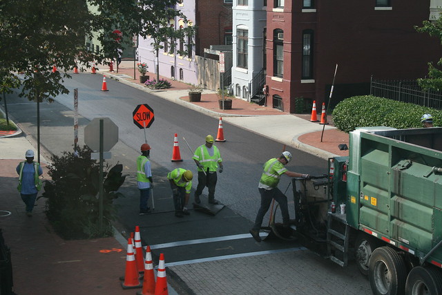
ANC Commissioner Brian Footer informed me that DDOT will apply a slurry seal to T Street from Second Street to Sixth Street one day from May 1 to May 6. The sealant fills cracks and slows asphalt deterioration. During the special day that DDOT applies the sealant, parking will be prohibited on T Street and driveways will be inaccessible from 8 am to 5 pm. DDOT will post notices 72 hours before the work begins.
DDOT applied the same treatment to Fifth Street back in 2013. Here are some photos of the process and the results.
You can go far on a single Metrobus from LeDroit Park
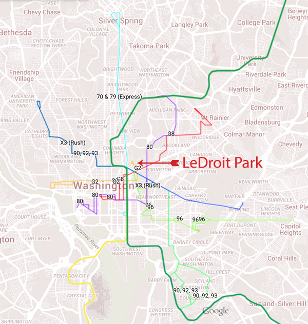
How far can you go from LeDroit Park on a one-seat Metrobus or Metrorail ride? Pretty far, actually. The map above illustrates all the bus lines and metro lines that run through or near LeDroit Park. View an interactive version of the map.
Residents are fairly familiar with our Metrorail system, but may not know the far reach of the Metrobus network. From LeDroit Park you can board a single bus and go to 14th Street, Dupont Circle, Georgetown, Adams Morgan, Woodley Park, the National Cathedral, Union Station, H Street NE, Eastern Market, and Barracks Row and never worry about parking. There are also several buses that go downtown to destinations like Chinatown, the Archives, Metro Center, Farragut Square, Foggy Bottom, and the Kennedy Center.
Here’s a breakdown of routes by the destinations they serve.
West to Shaw, Logan Circle, Dupont Circle, and Georgetown
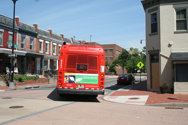
Board the G2 bus, which originates in LeDroit Park. You can also use this bus to carry heavy groceries from the Whole Foods on P Street or the Giant at 7th & O Streets.
West and north to U Street, Adams Morgan, Woodley Park, the National Cathedral, and Tenleytown
| Destination | 90,92,93 | 96 | X3 (rush) |
|---|---|---|---|
| Boarding point » | Florida Ave | Florida Ave., New Jersey Ave. |
Florida Ave |
| U Street | Yes | Yes | Yes |
| Adams Morgan | 90 & 93 | Yes | Yes |
| Woodley Park, National Cathedral, Tenleytown | Yes | Yes |
North to Petworth, Brightwood, and Silver Spring
Board the 70 bus or 79 express bus on Georgia Ave. For longer distances, board the 79 at Georgia and Florida Avenues (northbound). This bus makes fewer stops and doesn’t run on Sundays.
To Union Station, H Street NE, Capitol Hill, and east of the Anacostia
Ranked in relative order of speediness to the destination:
| Destination | 80 | 90,92,93 | 96 | X3 (rush) |
|---|---|---|---|---|
| Boarding point » | N. Capitol St. | Florida Ave. | Florida Ave, New Jersey Ave. |
Florida Ave |
| Union Station | 1 | 1 | ||
| H Street NE | 1 | 2 | ||
| Capitol Hill (the Capitol) | 2 | 1 | ||
| Capitol Hill (Eastern Market) | 1 | 2 | ||
| Capitol Hill (Barracks Row) | 1 | |||
| Capitol Heights | 1 | |||
| Historic Anacostia, Congress Heights | 1 |
To downtown
If you regularly ride Metro, you know the subway system occasionally breaks. If you’re looking for other routes to downtown or to other Metro lines, try these buses (ranked in relative order of speediness to the destination):
| Destination | G2 | G8 | 80 | 70,79 | 90,92,93 | 96 |
|---|---|---|---|---|---|---|
| Boarding point » | 3rd St, Elm St, V St | Rhode Is. Ave | N. Captiol St. | 7th St./Georgia Ave. | Florida Ave | Florida Ave, New Jersey Ave. |
| Foggy Bottom | 1 | |||||
| The Capitol | 2 | 1 | ||||
| Chinatown, Archives | 2 | 1 | ||||
| Dupont Circle | 1 | |||||
| Farragut Square | 1 | 2 | ||||
| McPherson Square | 1 | 2 | ||||
| Union Station | 1 | 1 |
See you on the bus!
Note: X3 runs along Florida Avenue, but only during rush hour. 79 is an express bus (it skips stops) that doesn’t run on Sunday.
Shoveling your sidewalk becomes mandatory next month
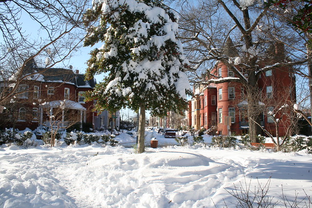
LeDroit Park residents woke up this morning to find four to six inches of snow on the ground. Please be kind to your neighbors and shovel your sidewalks.
Next month DC law will change to require homeowners to shovel their adjacent sidewalks within eight daylight hours after snowfall ceases.
Photo: Snowfall from the storm that buried the region in December 2009.
Updates: Howard, parking, planning, and the civic association
A few brief neighborhood updates:
Parking passes extended to the end of the year
The District has extended the expiration date of our visitor parking passes from September 30 to December 31.
Two groups downgrade Howard University
Moody’s, the bond-rating agency, has downgraded Howard University debt from A3 to Baa1, one notch above junk status. The agency cites worries over the financially foundering hospital, which ran up a $21-million loss last year. Other university departments, however, posted a combined $33-million surplus after the university’s aggressive cost-cutting measures last year.
U.S. News and World Report downgraded Howard University’s ranking by 22 slots to 142nd place. The magazine publishes its annual opinion of the “best colleges” in the nation, though there is plenty of criticism of the magazine’s methodology.
OP and DDOT to unveil the Mid City East draft plan Thursday
The Office of Planning and DDOT are holding an open house tomorrow to unveil their Mid City East small area plan proposal. The agencies launched the Mid City East Initiative last year “to holistically plan for transportation, commercial revitalization, redevelopment, historic resources, sustainability and parks and open space.”
The open house is tomorrow, Thursday, September 26 from 6:30‐8:30 pm at the McKinley Tech Auditorium (151 T Street NE) in Eckington.
LeDroit Park Civic Association will elect new officers next month
The association will elect new officers at its October meeting. The positions up for election are president, vice president, treasurer, and secretary. Any paid member may run and vote. Not a member? Join today!
The October monthly meeting is on Tuesday, October 22 at 7 pm in the basement of the Florida Avenue Baptist Church (enter on U Street).
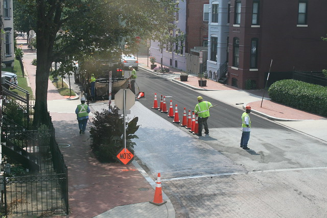
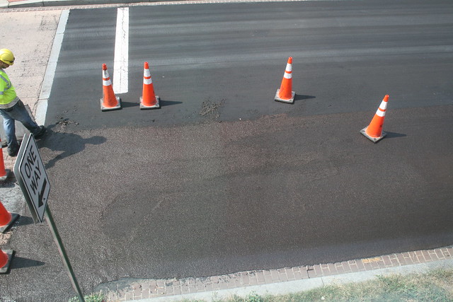
LeDroit streets get a slurry seal
A few streets became much darker yesterday evening. Throughout the day yesterday, DDOT applied a “slurry seal” to the surface of several neighborhood streets. The slurry seal is a type of liquid asphalt that is sprayed from the back of a truck and smoothed out by road workers. According to DDOT, the material “seals cracks on existing roads and protects the roadway surface from occurrences that cause normal wear and tear, thus slowing down the deterioration rate of the pavement.”
Here’s a photo of truck applying the material to 5th Street. The white stop line, granite crosswalk line, and various utility holes were covered in removable tape to prevent them from being paved.
The truck now applies the final strip of slurry. Notice how shiny it is when it’s freshly poured:
Here’s a close-up of a freshly poured section. The ends have to be manually smoothed out and feathered by road workers.
The seal runs over onto the brick gutter in a few places, but it otherwise smoothes over the cracks and cuts in the street pavements. The streets now sport a fresh, even surface like a freshly frosted cake.
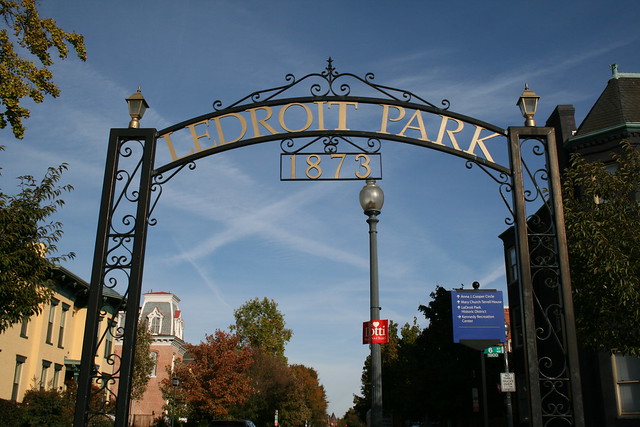
Speaking of asphalt, did you know that the man who founded LeDroit Park later became the “asphalt king” of America? LeDroit Park was founded in 1873 by Amzi Barber, who quit Howard’s Board of Trustees to go into real estate in DC. After a decade, Barber quit the real estate and started a business to spread a new technology: asphalt road paving. Though it seems ubiquitous now, it wasn’t until the late 19th century that governments started paving streets with asphalt. In 1888 Barber moved his asphalt business to New York, where it took off. He was so successful that his 1909 obituary in the New York Times described him as the “man who founded the asphalt industry in this country.”
It’s now a little easier to cross Florida Avenue at R Street
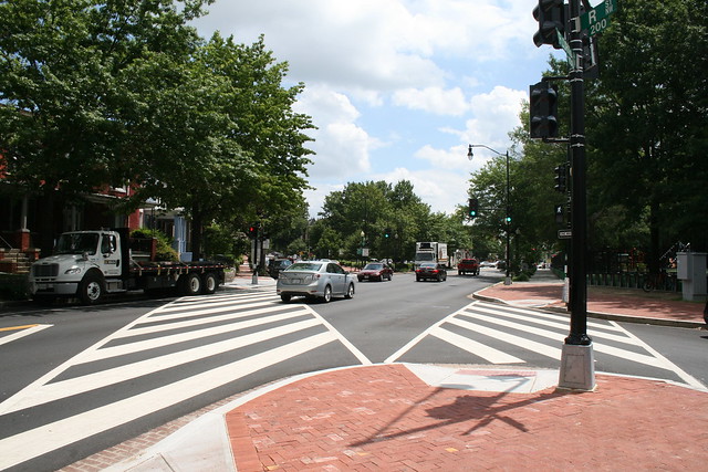
After much neighborhood lobbying, DDOT installed a new traffic signal at Florida Avenue and R Street NW in Bloomingdale. The light includes a pedestrian signal that will make it easier to cross Florida Avenue. Before DDOT installed the light, pedestrians had to pray that drivers on Florida Avenue would obey the law and yield at the crosswalks.

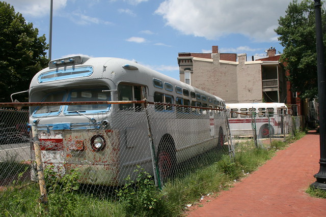
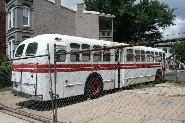
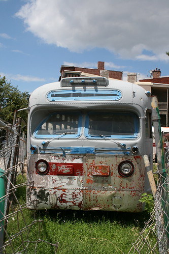
In unrelated news, two vintage transit buses are parked on the vacant lot at the northwest corner of the intersection.
Capital Bikeshare comes to LeDroit Park
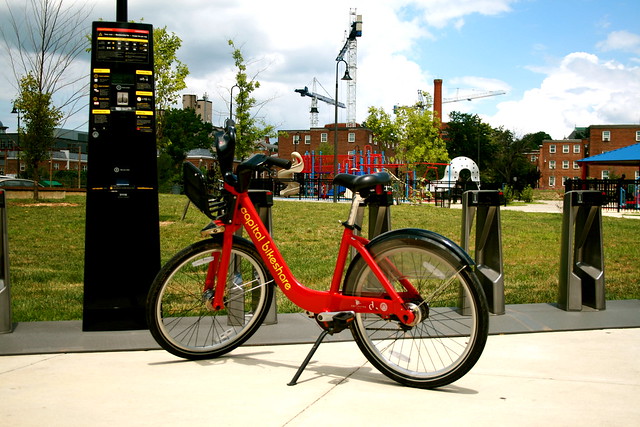
Earlier today DDOT installed LeDroit Park’s first Capital Bikeshare station. The station is located at the south entrance of the Park at LeDroit at Third and Elm Streets NW. This station fills a conspicuous hole in the city’s bikesharing map. The station was scheduled to be installed last fall, but delays from the Montréal-based supplier and confusion as to which District agency controlled the park meant that nothing happened until today.
As for the last bit of confusion, we give special thanks to residents like Mr. Hamilton and our ANC Commissioner Marc Morgan (1B01), who pushed the city to resolve the issue and install the station this month.
Here is the map with the location of the new station.
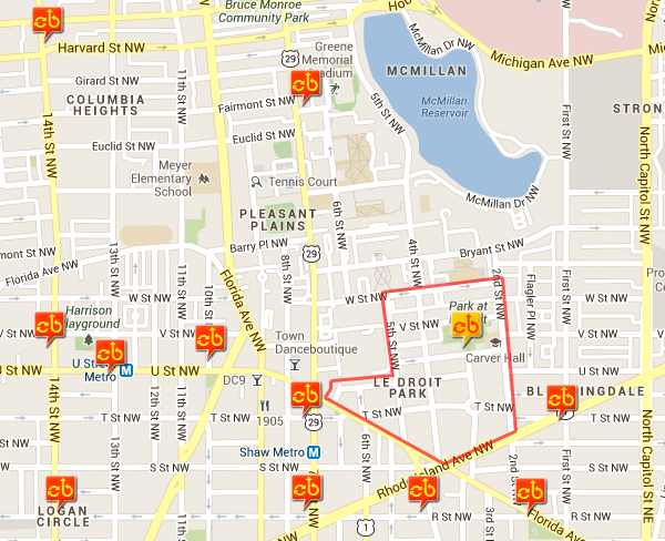
The new Capital Bikeshare station (yellow) in LeDroit Park (red outline)
Flooding and Howard University’s communication plan
Flooding, student behavior, and Capital Bikeshare are on the agenda for Tuesday’s civic association meeting. The meeting will be on Tuesday, September 25 at 7 pm in the basement of the Florida Avenue Baptist Church.
Here’s the full agenda:
- Howard University’s plan to address student behavior in off-campus housing
- An updates from the Flooding Task Force
- The new Capital Bikeshare station coming to LeDroit Park
- Public Safety in our neighborhood: How to keep our streets safe and clean
- Neighborhood events and activities
Everyone is encouraged to attend.


Recent Comments