DDOT to plant 16 trees in LeDroit Park this fall
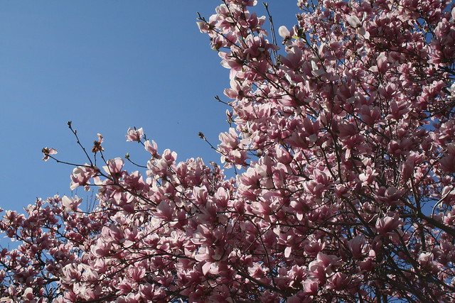
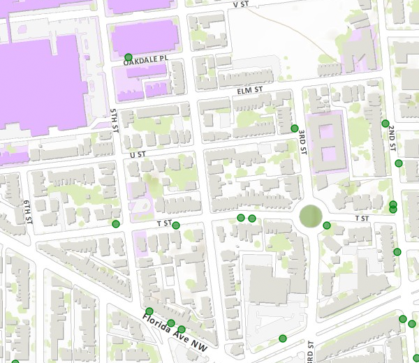
Fall is a good time to plant trees. DDOT has released its tree-planing map and LeDroit Park is slated to receive 16 trees. The agency only plants trees in public space, meaning the trees will be planted in the tree boxes or planting strips between the sidewalks and the curbs.
- 501 T Street
- 406 T Street
- 324 T Street
- 318 T Street
- 471 Florida Avenue
- 1934 3rd Street
- 1842 2nd Street
- Opposite 1915 2nd Street
- Opposite 1919 2nd Street
- 1948 2nd Street
- 1929 2nd Street
- 329 Rhode Island Avenue
- 455 Florida Avenue
Sweetgum (Slender Silhouette cultivar)
- 453 Florida Avenue
- Opposite 432 Oakdale Place
Cherry tree (Snow Goose cultivar)
- Southwest circumference of Anna Cooper Circle
That was fast!

It was only earlier this year that work began on 1915 6th Street (right). The property stood as a vacant lot for years, but was snapped up by a condo developer.
After being on the market for just a few days at $299,000, the 1-bedroom, 1.5-bathroom basement condo at 1915 6th Street is now under contract.
LeDroit Park has seen a good deal of reinvestment over the past few years despite the economy. A new condo is nearing completion at 5th St and Oakdale Place (bottom left) after sitting as vacant lot for years. 1907 3rd Street (bottom right), after sitting as a vacant apartment building for many years, is now a condo building.
NPR reporter Ari Shapiro and his husband are renovating the old McGill house at 1922 3rd Street (below).

Howard still owns a few properties in LeDroit Park
In reviewing Howard University’s proposed campus plan, we started to take account of all of the property in DC that the university owns. Up until 10 years ago, Howard University was accused of being LeDroit Park’s biggest slumlord, owning numerous properties in the neighborhood and letting them lie vacant, blighted, and decaying.
Under the reign of university president H. Patrick Swygert, Howard made a significant and commendable effort to rehab and sell many of its vacant properties in the neighborhood.
For instance, the university owned all but one house on 400 block of Oakdale Place. It let these houses lie vacant, blighted, and boarded up. Under Pres. Swygert, the university renovated the houses and sold them to employees. Today the 400 block of Oakdale Place is fully occupied and a new condo building is nearing completion on the western end.
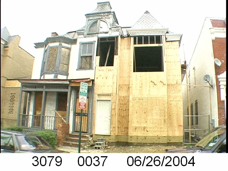
531 & 533 U St NW in 2004. Howard University renovated 531 (right) in 2004. Image from the DC government.
In other cases, the university renovated properties but has retained ownership. 531 U Street NW looked terrible in 2004 (right), but now looks very nice. We can’t quite tell if the house is occupied, but it consistently appears to be in good condition.
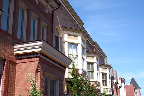
Elsewhere on the 500 and 600 blocks of U Street, Howard built historic infill houses (below) on vacant lots it owned on the north side of the street. The result is a block with with a continuous wall of housing on the street’s northern face. The houses’ façades are of high quality, with detailed brick work, ornate porches, and a variety of detailing.
The job is not entirely done, however, and Howard University retains ownership of a few properties that raise eyebrows. Let’s look at these three:
649 Florida Avenue (left) sits as a vacant lot, frequently collecting trash and debris. A university official told us that long ago Howard had considered using the lot to create a delightful pedestrian path to the university from the Shaw Metro. That never happened and now the lot sits vacant.
408-410 T Street (center) was the home of Walter Washington, DC’s first elected mayor. The university owns the property, and though it’s not blighted, it may be vacant. With some renovation work, this would make an excellent rental home for a Howard professor or anyone else for that matter.
326 T Street (right) is the Mary Church Terrell House, future home of the Robert and Mary Church Terrell House & LeDroit Park Museum and Cultural Center. Though it’s vacant and undoubtedly meets the District’s definition of blight, we are willing to cut the university more slack in this case since the eventual outcome will be a wonderful addition to the neighborhood. Unfortunately, the campus plan does not specify any additional Howard funding to restore the site.
In addition to the properties above, Howard owns a few more properties in LeDroit Park:
- Gravel parking lot at the SE corner of 5th and W Streets. (Square 3072, Lot 818). Campus plan does not mention any change to this lot.
- Carver Hall, 211 Elm St NW (Square 3084, Lot 830). Campus plan mentions the dorm’s decommission, but no reuse plans.
- Slowe Hall, 1919 3rd St NW (Square 3088, Lot 835). Campus plan mentions the dorm’s decommission, but no reuse plans.
- Howard University Hospital daycare, 1907-11 5th St NW (Square 3090, Lot 41)
- 420 T St NW – a house that appears to be occupied (Square 3094, Lot 800)
- Howard University Hospital (Square 3075, Lot 807)
- Parking garage bounded by 4th St, Oakdale Pl, 5th St, and V St. (Square 3080, Lot 73)
- Parking garage bounded by 4th St, V St, 5th St, and an alley. (Square 3072, Lot 52)
Though Howard retains a few problematic properties, it’s important to note the great strides the university has made in taking responsibility for its property portfolio in the neighborhood. A plan for these few remaining properties, even one in which the university retains ownership but leases, would put residents at greater ease.
Before the park, before the school, there were apartments
The Park at LeDroit was built on the site of the Gage-Eckington School. The school, built in the 1970s, was itself built over streets, houses and apartment buildings.
At the time, 3rd Street extended north of Elm Street and dead-ended just before reaching V Street. Oakdale Place extended eastward from its current terminus at the park to dead-end at what is now the eastern boundary of the park.
Two apartment buildings on the site, the Linden and the Harewood were named after local streets. Before the city changed the neighborhood’s street names, 3rd Street was Harewood Avenue and 4th Street was Linden Street.
We found this 1901 description of the apartments. What’s most notable is that the apartments are marketed to black Washingtonians and thus reflects the neighborhood’s turn-of-the-century transition from a white neighborhood to a black neighborhood.
THE LINDEN AND HAREWOOD FLATS
Le Droit Park—Corner of Harewood and Oak Streets.
The Colored American
January 5, 1901Mr. Banes the the real estate dealer has erected two of the most modern flats in Washington situated in Le Droit Park. The situation of these flats is an ideal one, on Third street, two doors from the Fourt street car line. The finish of the flats is elegant, and they have a preposessing appearance. They are three stories high, and each floor has three flats of four rooms each and bath. The whole flat is heated by steam, thus saving the necessary expense of buying fuel. Each flat has a parlor, dinning [sic] room, bed room, kitchen, and bath room and private hall rooms, and halls are heated by steam. The kitchens have a modern gas range, hot and cold water, cupboards, pantry attachment. These flats are no doubt, the best in the city. Persons having a large family can easily rent two adjoining flats saving the enormous rent of an entire house. They are thoroughly and artistically finished. The walls are papered and frescoed, and glasses of a large size, supported by a modern mantel piece are in each parlor. Le Droit Park has become a pleasant part of Washington in which to reside and these beautiful flats are a happy addition to the residences there. Mr. Banes has spared no pains in making these flats comfortable and inviting and already applications are being made for retals thereof. Colored people with first class reference who desire a beautiful part of the city in which to live, and at the same time occupy comfortable and improved apartments without renting a whole house, and paying high rent, can find a happy medium in these flats. The terms are easy. The buildings are open daily for inspection. For further information call at the office of Mr. Charles E. Banes, corner of 14th and G sts. n. w.
Casino Conviction
Last summer reports surfaced of a gambling house on Fourth Fourth Street between Elm Street an Oakdale Place. After a months-long investigation, the MPD finally swooped in and arrested two residents of the house in late January. After the arrest the MPD informed the neighborhood that they also found sound-proofing material attached the interior walls to reduce the noise emanating from the house. Whether this was out of respect for the neighbors or fear of getting caught, one cannot know.
Last month the police and U.S. Attorney obtained a conviction and Lt. Alberto Jova informs us that an eviction is also pending.
What’s That on the Grassy Knoll?
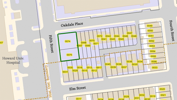
At the corner of Fifth Street and Oakdale Place, at the very edge of the Howard University campus, sits a fenced-in grassy knoll. The site is across the street from the hospital and sits just outside the historic district boundary. About a year ago a sign planted on the site announced the pending arrival of new houses. The sign came down many months ago and nothing much happened. Sure, Howard mowed the lawn, but not much else happened.
On Christmas Eve, Howard University sold the two lots for $250,000 each to Bowie-based Tito Construction Company LLC and just last month DCRA issued building permits for the two lots (#B1000822 & #B1000823). Each permit states the scope of work as
BUILDING A NEW 3-FLOOR WITH A CELLAR 2-UNIT FLAT STRUCTURE.
The lots are much larger than every other lot on the block and these two two-unit houses will likely be spacious.
Snow Mound
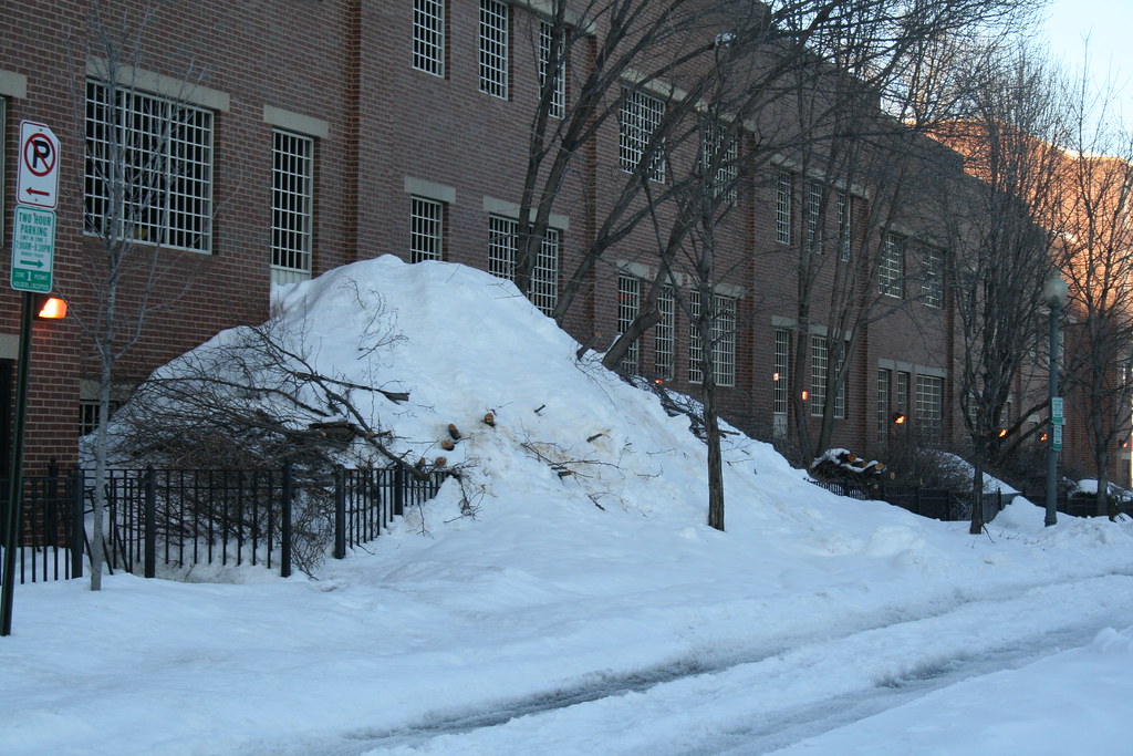
Unlike Metro, Howard University Hospital must stay open no matter the weather. As such the groundskeepers are quick to remove snow the moment the first flake hits the ground. The employee parking garage on the block bounded by Fourth Street, V Street, Fifth Street, and Oakdale Place also needs its top level cleared of snow. But where does the snow from the top level go? Well, over the edge it seems.
Eye in the Sky (1988 – 2009)
What a difference twenty-one years make. Below are two satellite photos of LeDroit Park— one taken in 1988 and the other taken in 2009. Toggle back and forth between the two to see how the neighborhood’s footprint has changed.
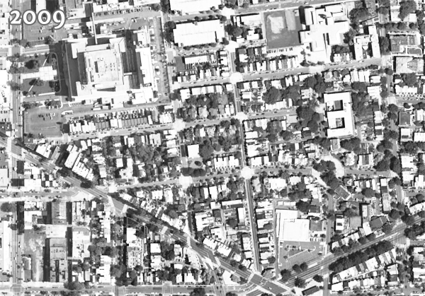
There are a few noticeable changes:
- Howard University Hospital built an annex behind the main hospital building.
- The entire block bounded by Fourth Street, Fifth Street, V Street, and Oakdale Place is now a multi-level parking garage.
- In 1988, the 500 block of U Street looked gap-toothed; new houses have since been built to fill out the entire north side of the street.
- Street intersections have been replaced with concrete while the roadways remain asphalt.
- The tree canopy is much more expansive now (or the 1988 photo was taken in the winter).
- Houses have been built on the once-vacant land around the northeast corner of Fourth and U Streets.
- The intersection of T Street, Sixth Street, and Florida Avenue has been reconfigured, making way for the pocket park home to the LeDroit Park entrance arch.
- The Schoolhouse Lofts condo building has since been built at Second and V Streets.
Did we miss anything?
Old Street Names
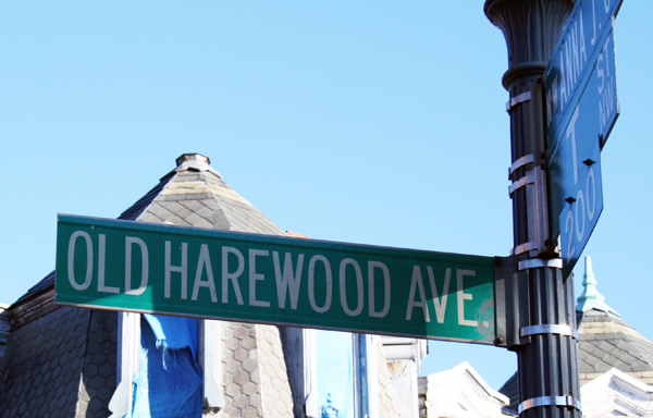
Careful observers occasionally spot the old street signs adorning a few of the light poles in LeDroit Park. When the neighborhood was originally planned, most of the streets were named after trees. LeDroit Park’s street system didn’t fit with the L’Enfant Plan in either name or alignment—much to the dismay of the District commissioners—and the street names were eventually changed to fit the naming and numbering system.
A perusal of old maps reveals that the street names changed over time, not all at once. Elm Street is the only street that has retained its name. Since your author lives on Elm Street he has learned to respond to puzzled faces that know that Elm doesn’t fit the street naming system: “It’s kinda like U-and-1/3 Street”.
Anna J. Cooper Circle didn’t have a name at all until 1983, when it was restored to its circular form after a decades-long bisection by Third Street.
Just outside of LeDroit Park, the city renamed a few streets as well: 7th Street Road became Georgia Avenue and Boundary Street, the boundary of the L’Enfant Plan, became Florida Avenue.
Here is a table matching the current street names with their previous names.
| Old Name | Current Name |
| Le Droit Avenue | 2nd Street |
| Harewood Avenue | 3rd Street |
| Linden Street | 4th Street* |
| Larch Street | 5th Street |
| Juniper Street | 6th Street |
| Elm Street | (same) |
| Boundary Street | Florida Avenue** |
| 7th Street Road | Georgia Avenue** |
| Oak Court | Oakdale Place |
| Maple Avenue | T Street |
| Spruce Street | U Street |
| Wilson Street | V Street** |
| Pomeroy Street | W Street** |
| (unnamed before 1983) | Anna J. Cooper Circle |
| * For a short period, 4th Street was called 4½ Street. ** Though these streets were just outside the original LeDroit Park, we have included them for reference. |
|
Signs bearing the old street names have reappeared in the neighborhood, and according to the Afro-American, were put up in 1976: “The LeDroit Park Historic District Project was instrumental in getting the D.C. Department of Transportation to put up the old original street names for this Historic District Area under the present street name signs”.1
Unfortunately, some of the signs are showing their 33 years of weather, as this sign at Third and U Streets shows.

Eventually these signs will have to be replaced, but rather than placing the old names onto modern signs using a modern typeface, we suggest something that evokes the history without being mistaken for the current street name:

White text on a brown background is the standard for street and highway signs pointing to areas of recreation or cultural interest. Seattle started using the color scheme to mark its historic Olmsted boulevards and New York has long used the combination for street signs in its historic districts. The adoption of this style of sign would alert visitors and residents to the neighborhood’s historic identity while the different color and typeface would prevent confusion with the actual street names (U St NW in this case). Typographers would be pleased by the use of Big Caslon Medium, a serif typeface based on the centuries-old Caslon typeface.
- Hall, Ruth C. “Historic Project”. Washington Afro-American. 1 May 1976.






Recent Comments