
President Obama comes to Howard, Wizards may come to Howard
President Obama visited the Howard University College of Medicine today to deliver a speech on the negative impact of climate change on public health. I caught some footage of the president’s motorcade as it passed up 7th Street and crossed Florida Avenue.
In other news, the Wizards are considering constructing a practice facility as part of a mixed-use building on university land just west of Georgia Avenue. No deal has been finalized and the team will likely seek a tax-exempt bond from the District Government to finance the building.
Howard promises to renovate the Terrell House
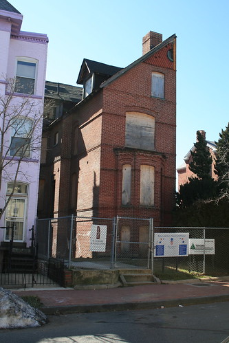 After years of neglect, Howard University has agreed to finish renovations of the Mary Church Terrell House (326 T Street NW).
Mary Church Terrell was a civil rights leader who lived from 1863 to 1954 and spent the last decades of her life in LeDroit Park. She was instrumental in lawsuit, D.C. vs. J. R. Thompson Co., Inc., that that led the U.S. Supreme Court to desegregate all restaurants in D.C. in 1953.
Mary Church Terrell and her husband Robert Terrell, D.C.’s first black judge, willed the house to their daughter and, upon her death, to Howard University, which took control of the house in 1998.
The university had long planned to renovate the house and turn into a museum focused on the Terrells and the history of the neighborhood. Those plans never came to fruition.
However, in a Feb. 26 meeting between community leaders, including me, and Howard University President Wayne Frederick, the president assured us that restoration work will start on the house within six months.
We have not seen the exact plans of the physical restoration the university will complete, but Dr. Frederick wants to revisit the concept of housing a museum as he perceives a lack of support for that specific use.
The president is well aware of the vast community support toward the house’s physical restoration. The LeDroit Park Civic Association voted in January to send a letter to the university’s leadership expressing disappointment at the state of the Mary Church Terrell House and the Walter Washington House (408-410 T Street NW), both of which are Howard properties in different state of disrepair.
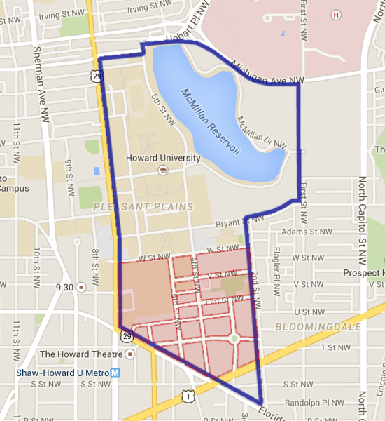
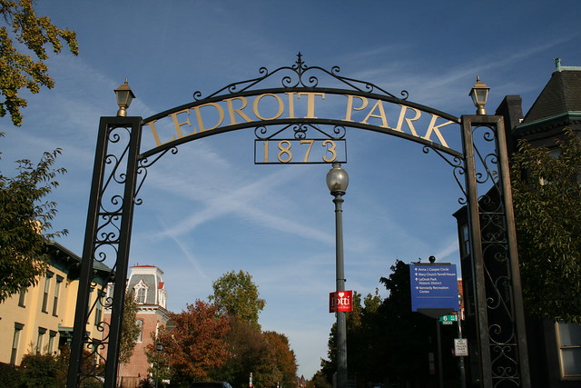
How LeDroit Park’s demographics have changed since 1970
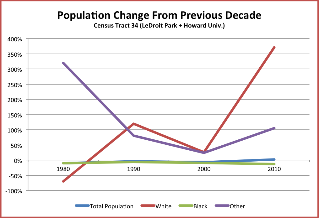
Since 2000 the census tract that includes LeDroit Park has grown more educated, more expensive, and wealthier. Meanwhile the tract’s total population held steady after decades of slow decline. While the white population has increased, the census tract is still overwhelmingly black.
Governing Magazine recently ran a story on gentrification in DC and labeled Census Tract 34, which contains LeDroit Park and Howard University, as “gentrified“. LeDroit Park has certainly changed over the years and I finally got around to compiling decennial census data from 1970 to 2010 as well as data from the American Community Survey.
Let’s start off with the biggest changes.
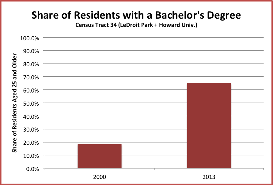
LeDroit Park is now better educated than the DC region and the nation
Data from Governing show that the share of adults age 25 and older who earned a bachelor’s degree more than doubled from 18.5% in 2000 to 64.9% in 2013. In fact the neighborhood catapulted over the regional figure (48%) and the national figure (28.8%).
Home prices fluctuate more drastically in LeDroit than in the rest of DC
Data from NeighborhoodInfoDC show that until 2004, the median sale price of single-family homes in the neighborhood moved closer to the average of the median values of all DC census tracts. The median price in LeDroit Park quintupled from 1996 to 2005, marking the greatest period of price appreciation. Though prices fell a bit from the recession, the neighborhood’s median price is slowly converging on the District-wide figure. (Disclosure: I do consulting work for the think-tank that produces NeighborhoodInfoDC)
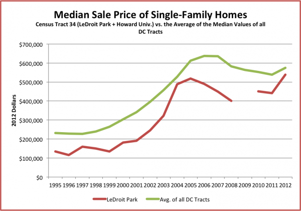
Note: 2009 data not available
Governing’s data of the median home value (both single-family homes and condos) show that housing prices nearly doubled from 2000 to 2013.

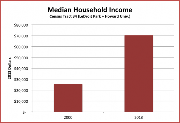
Median household income more than doubled from 2000 to 2013
(For comparison, median household income nationwide declined during this period.)
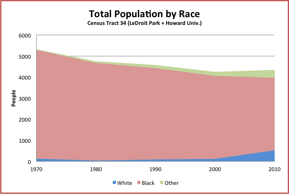
LeDroit Park is still predominantly black
The population of LeDroit Park and Howard’s campus held steady since 2000 after decades of modest decline. Though the number of whites more than tripled and number of blacks fell 13% from 2000 to 2010, our census tract is still 79% black. A few years ago I got a limited data set of the 2010 Census from the Office of Planning and was able to separate LeDroit Park figures from the rest of the census tract that lies north of W Street. Even then I found that the neighborhood was 70% black.
One popular gentrification narrative is that the process turns poorer black neighborhoods into wealthy white neighborhoods. While income and home values in LeDroit have soared, it still remains a predominantly black neighborhood.
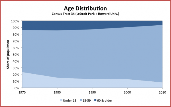
Lil’ LeDroiters are becoming scarcer
From 1970 to 2010, the population of residents under 18 tumbled from 23% of the population (1,244 children) to 8% of the population (350 children). For comparison, DC’s under-18 population in 2010 stood at 17%.
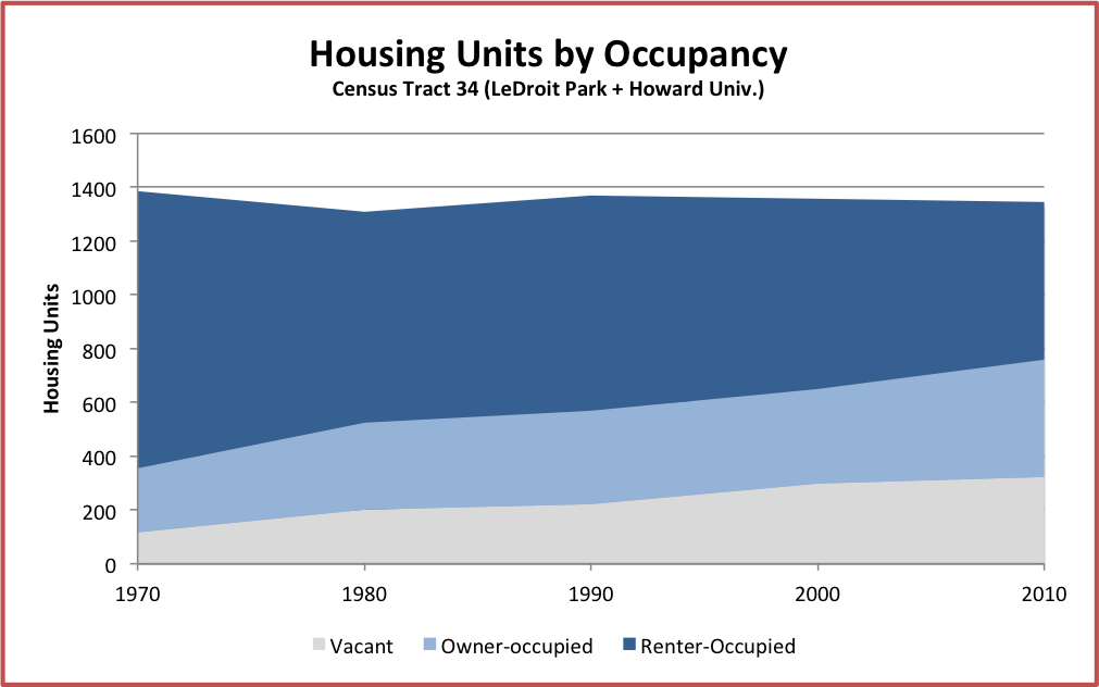
Homeownership has expanded, the housing stock has not
This was one of the more surprising facts. Despite construction of numerous infill rowhouses (especially on the 300 and 500 blocks of U Street) and despite the conversion of many one-unit rowhouses into two-unit rowhouses, the total number of housing units is slightly lower than in 1970. Also, vacancy has been rising, which contradicts what I have seen since I moved here in 2009. Perhaps the vacancy numbers were driven by the remodeling of the 161 units at Kelly Miller or perhaps Howard University dorm rooms do not count as “occupied” since many are vacant during the summer.
The definition of gentrification is a matter of great debate, but Governing defined it as any census tract that met the following criteria from the 2000 Census to the 2010 Census:
- It must start out poorer, i.e. “median household income and median home value needed to fall within the bottom 40th percentile of all tracts within a metro area at the beginning of the decade.”
- It must end up pricier and more educated, i.e. “in the top third percentile for both inflation-adjusted median home values and percentage of adults with bachelors’ degrees.”
According to Governing’s analysis, our tract, like half of the other DC tracts that met the first condition above in 2000, satisfied the second condition in 2010 and thus gentrified.
Sources:
- Longitudinal Census Bureau data (1970 – 2010) came from the US 2010 project, which used a peer-reviewed method adjust older tract data to conform to the latest tract boundaries.
- Governing, which used Census Bureau data.
- American Community Survey, a Census Bureau project that collects detailed demographic data for years between and overlapping each decennial census.
Our census tract (outlined in blue) is larger than the neighborhood and includes much of the Howard University campus.
Howard opens new buildings, reduces staff
Howard University is reforming its hospital while its rank as DC’s largest employer slips. These changes come as the university looks to improve its academic program and its finances.
Financial difficulty is nothing new for Howard. In 2013 we reported that sequestration had cut its annual appropriate from Congress, enrollment had dropped, and one of its Trustees publicly warned of the university’s financial straits. Later that year, Moody’s downgraded the university’s bond rating from A3 to Baa1 as the hospital ran a $21-million loss.
The university furloughed staff and cut positions, but last year Moody’s downgraded the university further from Baa1 to Baa3, citing the hospital’s losses, which had increased to $37 million.
Since then the university has hired Paladin, a healthcare management consultancy, to reverse the hospital’s losses. University President Wayne Frederick recently told the Washington Business Journal that the hospital has made progress, particularly in billing more efficiently. (The fee-for-service model may be lucrative for healthcare providers, but the Obama Administration is trying to move the country away from it.)
Last week the hospital announced it would lay off 25 management positions and look to reduce staff further.
Meanwhile the university and its hospital have slipped in their rankings as DC’s largest employers. Over the past ten years, the university fell from first to seventh while the hospital fell from seventh to fifteenth.
| Employer | 2004 Rank | 2014 Rank |
|---|---|---|
| Georgetown University | 3 | 1 |
| Washington Hospital Center | 4 | 2 |
| George Washington University | 2 | 3 |
| Children’s Hospital | 5 | 4 |
| American University | 8 | 5 |
| Georgetown University Hospital | 9 | 6 |
| Howard University | 1 | 7 |
| Fannie Mae | 6 | 8 |
| Booz Allen Hamilton Inc. | 113 | 9 |
| Allied Barton Security Services LLC | – | 10 |
| Red Coats | 40 | 11 |
| Providence Hospital | 10 | 12 |
| George Washington University Hospital | 18 | 13 |
| Sibley Memorial Hospital | 13 | 14 |
| Howard University Hospital | 7 | 15 |
But the outlook isn’t all gloomy. The university recently completed two new dorms on 4th Street just north of the neighborhood and is nearing completion of its top-notch Interdisciplinary Research Building at Georgia Avenue and W Street.
LeDroit Park was a hot market in 1978, but much more affordable than today
A neighbor pointed us to this 1978 article in the Washington Star naming LeDroit Park the neighborhood with the highest annual appreciation in single-family home assessments. Home values increased 51% in just two years.
Much of the increase was attributed to Howard University’s purchase of homes in the neighborhood. The university has since divested itself of nearly all single-family houses here.
The average neighborhood assessment back then, according to the assessor quoted in the article, was about $25,000. Even in 1978 that was considered low and the figure was about 1.5 times the District’s median household income in 1979, which was $16,211. In 2013 the average sales price of a LeDroit Park home (including condos) was $562,029, which was 9.2 times the District’s median household income in 2013, which was $60,675.
Join the war on rats at Tuesday’s Civic Association meeting
LeDroit Park will be part of a rat control pilot program sponsored by the city. Learn how you can participate at the next LeDroit Park Civic Association meeting, which will be held on Tuesday, Nov. 26 at 7 pm in the basement of the Florida Avenue Baptist Church (623 Florida Ave NW – enter on U St). The full agenda includes:
- Rat control pilot project coming to LeDroit Park
- Howard University community update
- Common Good City Farm presentation
- Public safety update
- Community open forum
- Holiday party plans (Dec. 15, 4 – 7 pm at Shaw’s Tavern)
All neighbors are welcome and encouraged to attend.
Want to join the civic association? Join online or at the meeting!
Howard convening neighbors and students on conduct issues

Howard University is hosting a forum next week to discuss students’ off-campus conduct. While most students are properly behaved and cause no problems, a few students have a penchant for raucous partying and sloppy trash disposal. The meeting will be on Wednesday, October 9 at 6:30 pm at the Blackburn University Center‘s “Forum” (2397 6th Street NW – first floor to the left of the main entrance).
In addition to interested neighbors, the university has invited the Student Association leadership, campus police, the university’s community relations office, MPD, and university representatives who enforce the Student Code of Conduct.
In other news, Howard University President Sidney Ribeau announced that he will retire (a polite way to say resign) at the end of the calendar year. During Mr. Ribeau’s five-year tenure, the university suffered declining enrollment and declining revenues.
Photo credit: “Red Solo cups” by TheKarenD on Flickr
Updates: Howard, parking, planning, and the civic association
A few brief neighborhood updates:
Parking passes extended to the end of the year
The District has extended the expiration date of our visitor parking passes from September 30 to December 31.
Two groups downgrade Howard University
Moody’s, the bond-rating agency, has downgraded Howard University debt from A3 to Baa1, one notch above junk status. The agency cites worries over the financially foundering hospital, which ran up a $21-million loss last year. Other university departments, however, posted a combined $33-million surplus after the university’s aggressive cost-cutting measures last year.
U.S. News and World Report downgraded Howard University’s ranking by 22 slots to 142nd place. The magazine publishes its annual opinion of the “best colleges” in the nation, though there is plenty of criticism of the magazine’s methodology.
OP and DDOT to unveil the Mid City East draft plan Thursday
The Office of Planning and DDOT are holding an open house tomorrow to unveil their Mid City East small area plan proposal. The agencies launched the Mid City East Initiative last year “to holistically plan for transportation, commercial revitalization, redevelopment, historic resources, sustainability and parks and open space.”
The open house is tomorrow, Thursday, September 26 from 6:30‐8:30 pm at the McKinley Tech Auditorium (151 T Street NE) in Eckington.
LeDroit Park Civic Association will elect new officers next month
The association will elect new officers at its October meeting. The positions up for election are president, vice president, treasurer, and secretary. Any paid member may run and vote. Not a member? Join today!
The October monthly meeting is on Tuesday, October 22 at 7 pm in the basement of the Florida Avenue Baptist Church (enter on U Street).
Is Howard University in financial trouble?
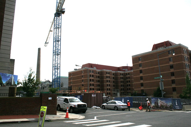
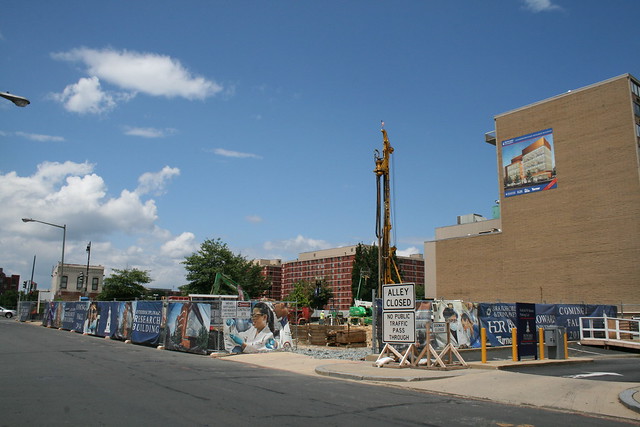
Over the past few months, reports have trickled in warning about Howard University’s fiscal health. The news is not good. The school’s enrollment had dropped, its annual Congressional appropriation has fallen, and the hospital is furloughing workers to make up for large losses. On the bright side, Howard’s capital improvement program is underway and several cranes tower over three active construction projects on the campus (more on that later).
As for fiscal issues, the first warning came in June, when a Howard University trustee warned, “Howard will not be here in three years if we don’t make some crucial decisions now.” Whether the trustee was exaggerating Howard’s fiscal straits due to internal politics remains unknown, but a potential sequester of the university’s Congressional appropriation adds to the unease.
Since its founding in 1867, Howard has received an annual appropriation from Congress much the way state universities receive appropriations from their state legislatures. The appropriation has remained steady over the past few years, but sequestration is expected to reduce the amount. Federal funding accounts for a sizable 27% of the university’s operating budget, meaning any change will be noticeable.
Furthermore, the recession, which hit black Americans especially hard, is often cited as a major factor contributing to last year’s 5% enrollment decline, further depriving the university of tuition revenue. Tuition for the 2013-14 academic year is set for $22,783, excluding housing, a difficult stretch for most families.
In June the university announced it would layoff 75 employees and earlier this month, the hospital announced it will furlough 1,700 staff for eight days. The hospital has suffered a sharp decline in patients and revenue.
Money problems are nothing new at Howard. In fact, tight university finances are a theme that appears in The Black Apollo of Science, the biography of Ernest Everett Just, a 1920s and ’30s Howard biology professor and LeDroit Park resident. The university has survived tough times before and it is rare for large universities in the U.S. to shut down.
Some of the bad news is more than just financial. Late last month, news leaked that the university and its development partner had parted ways on the Howard Town Center project, further delaying the mixed-use development project the university has been planning for years.
Lift every crane and build
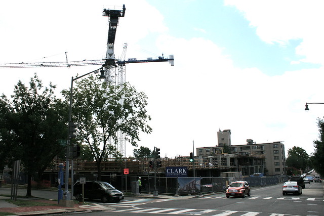
But there’s good news, too! Visit LeDroit Park’s newest Capital Bikeshare station and you’ll spot the cranes that tower over the Howard campus. In fact, the university is currently constructing three new buildings: two new dorms on 4th Street and an interdisciplinary STEM research building at Georgia Avenue and W Street.
The two dorms at 4th and College Streets NW and 4th and W Streets NW are part of the university’s plan to improve and increase on-campus housing. By making 4th Street NW a residential spine, the university hopes to keep its students in newer buildings physically close to academic buildings. The proximity is expected to boost academic performance and the newness of the housing is expected to attract top-performing students.
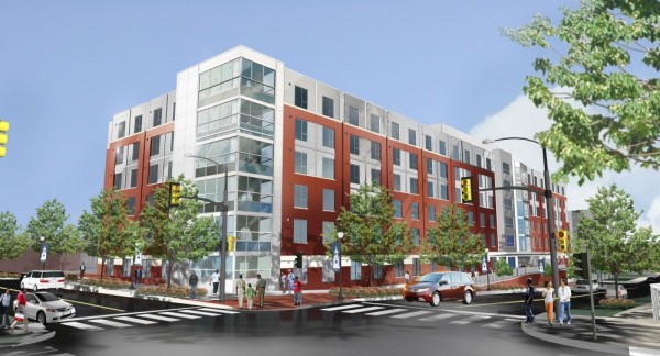
Here is a photo of the new dorm now under construction at 4th and College Streets NW:

When finished:
Design of the new Howard University dorm at 4th and College Streets NW.
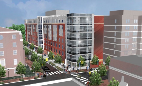
Here is a photo of the new dorm now under construction at 4th and W Streets NW:
When finished:
Design for the new Howard dorm at 4th and W Streets NW
At Georgia Avenue and W Street, Howard is constructing a new building for STEM research. The new high-tech facility is expected to boost the university’s research profile and its ability to win research grants that require advanced research facilities. The LeDroit Park Civic Association supported the zoning relief necessary to build this building.
When finished:
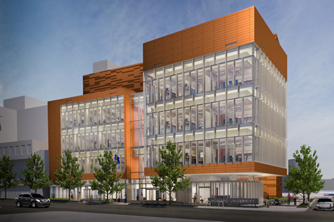
Design of Howard University’s Interdisciplinary Research Building
Though the university’s fiscal woes make headlines, several important capital improvements are well underway.
Flooding and Howard University’s communication plan
Flooding, student behavior, and Capital Bikeshare are on the agenda for Tuesday’s civic association meeting. The meeting will be on Tuesday, September 25 at 7 pm in the basement of the Florida Avenue Baptist Church.
Here’s the full agenda:
- Howard University’s plan to address student behavior in off-campus housing
- An updates from the Flooding Task Force
- The new Capital Bikeshare station coming to LeDroit Park
- Public Safety in our neighborhood: How to keep our streets safe and clean
- Neighborhood events and activities
Everyone is encouraged to attend.


Recent Comments