
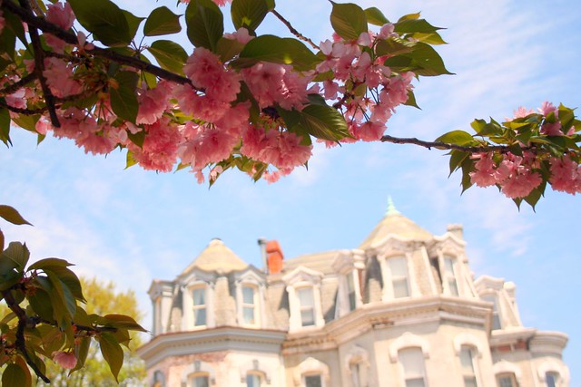
Buy a McGill house for $1.4 million
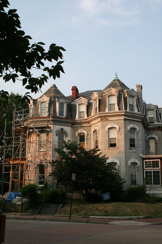
One of the original McGill houses of LeDroit Park is up for sale for $1.4 million. The Second Empire manse on Anna Cooper Circle (1901 Third St, specifically), contains seven bedrooms and 4.5 bathrooms across 3,235 sq. ft. The house is one-half of a duplex and both are pictured in the 2010 photo above (1901 is on the right).
The house’s mansard roof is a signature feature of the Second Empire style along with window moulding, ornate porches, ornate brackets, prominent eaves, and prominent cornices.
In the late 19th century, the house was the home of General William Birney, a southern abolitionist who served in the Union Army during the Civil War. After the war, Birney moved to Washington to establish a law practice. He lived in LeDroit Park for a few years and eventually retired to Montgomery County, Md.
The house previously sold for $133,636 in 1997.
Lick free ice cream on Thursday
Meet your neighbors over free ice cream sundaes, ice cream floats, banana splits, brownies, and cookies. The LeDroit Park Civic Association is hosting an ice cream social on Thursday, July 30 from 6 to 8pm in Ms. Norman’s backyard (1853 3rd St NW).
Brianne Nadeau, who represents Ward 1 on the DC Council, will be in attendance.
Attendance is free, but please R.S.V.P. so we know how much ice cream to buy
DDOT to plant 16 trees in LeDroit Park this fall

Fall is a good time to plant trees. DDOT has released its tree-planing map and LeDroit Park is slated to receive 16 trees. The agency only plants trees in public space, meaning the trees will be planted in the tree boxes or planting strips between the sidewalks and the curbs.
- 501 T Street
- 406 T Street
- 324 T Street
- 318 T Street
- 471 Florida Avenue
- 1934 3rd Street
- 1842 2nd Street
- Opposite 1915 2nd Street
- Opposite 1919 2nd Street
- 1948 2nd Street
- 1929 2nd Street
- 329 Rhode Island Avenue
- 455 Florida Avenue
Sweetgum (Slender Silhouette cultivar)
- 453 Florida Avenue
- Opposite 432 Oakdale Place
Cherry tree (Snow Goose cultivar)
- Southwest circumference of Anna Cooper Circle
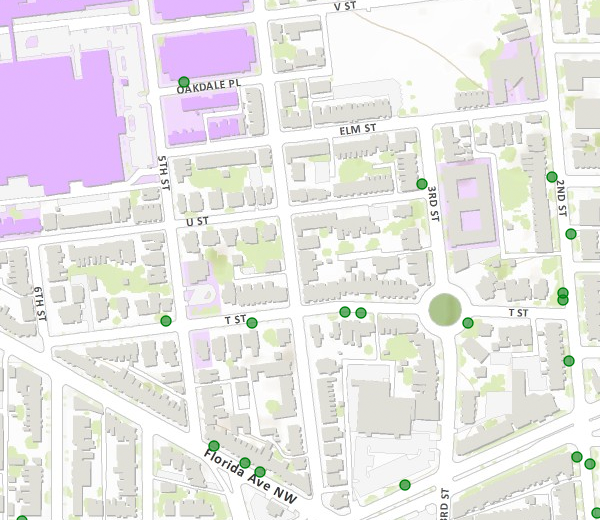
Capital Bikeshare comes to LeDroit Park
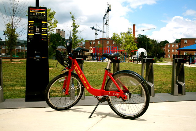
Earlier today DDOT installed LeDroit Park’s first Capital Bikeshare station. The station is located at the south entrance of the Park at LeDroit at Third and Elm Streets NW. This station fills a conspicuous hole in the city’s bikesharing map. The station was scheduled to be installed last fall, but delays from the Montréal-based supplier and confusion as to which District agency controlled the park meant that nothing happened until today.
As for the last bit of confusion, we give special thanks to residents like Mr. Hamilton and our ANC Commissioner Marc Morgan (1B01), who pushed the city to resolve the issue and install the station this month.
Here is the map with the location of the new station.
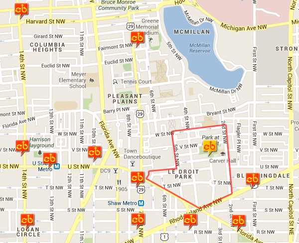
The new Capital Bikeshare station (yellow) in LeDroit Park (red outline)
Just who was Ernest Everett Just?
An academic’s prestige is usually measured by the degree to which his peers admire his work. Any job where success depends on reputation is bound to be a difficult and political career. Howard biologist Ernest Everett Just (1883-1941), who lived at 412 T Street in LeDroit Park, faced a constant struggle for recognition for his groundbreaking work in biology in the early 20th century.
I occasionally give history tours of the neighborhood. My tour touches on two major themes: the neighborhood’s eclectic architecture and the prominent black Americans who lived in LeDroit Park. I had never heard of Just before moving to LeDroit Park, but in researching topics for my tour I came across a 1995 postage stamp commemorating him. This makes him the first of two LeDroit Park residents featured on postage stamps.

Two months ago, a neighbor who was a researcher at Howard University recommended Kenneth Manning‘s 1983 biography of Just. He assured me that the book, entitled Black Apollo of Science, detailed all the administrative problems at Howard that still exist to this day.
I picked up the book hoping to read historical accounts of LeDroit Park while Just lived in the neighborhood. Though there was very little about the neighborhood, the book provided interesting stories about Howard University’s administrative and financial troubles during the early 20th century.
The book was light on LeDroit Park and Washington because Just himself increasingly disliked teaching at Howard and the pervasive racism he faced living in the United States. In the 1920s, midway through his career, Just began to spend more time conducting research at research institutes in Berlin; Naples; and Roscoff, France. He deliberately avoided returning to the Marine Biology Laboratory in Woods Hole, Massachusetts, where he felt he was socially isolated because of his race. Just saw Europe as an escape from racism he faced at home.
In Europe Just could finally attend the same operas he had seen advertised in Washington’s whites-only venues and he could travel and book hotels without worrying that his reservations would be rejected due to Jim Crow.
Whether Just was pursuing his PhD at the University of Chicago or conducing research in Massachusetts or Europe, his wife and children remained in LeDroit Park at 412 T Street. But as Just eventually grew apart from the United States, he also grew apart from his wife. Just took several lovers in Europe during his research stints and he eventual filed for divorce from his wife Ethel in the late ’30s. This was a formality, though, as their love had died many years ago.
Though Just was in France at the time of the 1940 census, the census ledger lists him as the absent head of household at 412 T Street.

The Just family stood out for its educational attainment. Notice that in column 14, Just is listed as having completed eight years of college, an outstanding accomplishment even by today’s standards. His wife had finished six years of college, his son four, and his daughter Maribel, aged 17, was in her first year of college.
Out of pure luck, Just was listed on line 68, which was one of two lines per page that the Census Bureau selected for supplmentary questions.

Here Just stands out again. Though most LeDroit residents were listed as maids, porters, or laborers, Just’s profession is listed as “Zoology professor” at Howard University.
Just’s life was not easy. He grew up in poverty and his father died when Just was a child. Just’s mother was a teacher who valued his education dearly and she sent him as a teenager to a boarding school in New Hampshire. During his time at boarding school, his mother died, leaving Just orphaned but independent.
After boarding school, he proceeded to Dartmouth to study classics and biology, the field to which he devoted his entire career. Since few universities at the time would hire black researchers or professors, Just took a position at Howard University and in 1912 became the head of Howard’s Department of Zoology.
The Howard position was Just’s main source of income for the rest of his life and he used it, along with a few private grants, to fund his research in Massachusetts and Europe. Though Just kept his position at Howard until his death, he spent many semesters and summers studying marine biology far away from Washington. Howard, it seems, was only a source of income for Just, as he frequently battled with the university’s administration for more equipment, more funding, and more research time.
Howard’s presidents, especially Mordecai Johnson, demanded that Just focus less on research and more on teaching and building a graduate zoology program.
Johnson wasn’t the only person pressuring Just. White philanthropists who wanted to raise academic achievement and living standards of American blacks funded Just’s work with the goal that he would train aspiring black scientists and doctors. Their hope was that Just would train black biology students so they could study medicine and return to the rural south where white doctors would not treat black patients.
Just, however, wanted philanthropic funding to support his biological research efforts, not his teaching efforts. Just preferred research and appeared far more interested in advancing the human understanding of cell biology.
Old letters Manning uncovered reveal that Just held a low opinion of Howard undergraduates during his tenure. Just thought teaching biology to them was a waste of time and would distract him from important research.
To teach or to research? This is an old academic controversy. Many professors prefer to conduct research because they find it more intellectually satisfying and because it builds their careers, expertise, and reputations. At universities that rely heavily on tuition fees for their income, administrators realize that teaching is an important source of income.
For Just, the written correspondence between him and various philanthropies shows that because he was black, he was expected to carry the herculean task of advancing both the human understanding of biology and the welfare of his race— a burden his white benefactors did not place on white scientists. These expectations, though well intentioned, continually hindered Just’s career as his appeals for research grants rarely bore fruit. Various foundations and Howard administrators urged Just to spend more effort building a biology program and producing trained biologists.
Just found a warmer reception in Germany, Italy, and France, where scientists were more eager to collaborate with him and build on his work. While in Europe, Just dated several women. He even established residence in Latvia briefly so he could quickly file for divorce from his wife in Washington. He eventually decided to mary his German mistress and start a life in Europe, even if it meant resigning his post at Howard and living in penury in Europe.
Failing to win grants, though, Just held onto his Howard position as his sole source of income. Just’s time in Europe was productive. He published his most renowned works on cell biology and cell fertilization during this self-exile.
His new-found haven across the Atlantic didn’t remain peaceful for long. Though he had tried to escape racism in the United States, Nazi violence had made Berlin inhospitable. In Italy, Just’s appeals to Mussolini for research funding went nowhere and Italian biology conferences became fascist propaganda events.
Just’s final European post in France came under Nazi control and Just was ordered to leave. The advancement of fascism eventually made this European exile untenable. Sadly, everywhere Just went, some virulent -ism— racism, fascism, Nazism— eventually caught up with him.
Just returned to the United States with his new wife and newborn child. His new wife and child settled in New Jersey, but Just had to return to work for pay at Howard. Suffering from pancreatic cancer, Just stayed with his sister Inez at 1853 3rd Street, here in LeDroit Park. His health was in rapid decline and in October 1941 Just died.
Despite having overturned a ruling theory of cell fertilization, Just never fully received the professional recognition he desired and deserved. He was always tied to Howard, even though he wanted desperately to leave to focus solely on research. Howard tied him to Washington, a city whose segregation degraded him. Washington also tied him to a wife he no longer loved.
Manning’s book is very well researched and combs through many of Just’s letters to colleagues, mentors, friends, and lovers. It tells a fascinating account of race relations in America, the history of biology research, and one man’s unhappy task facing down all these problems.
Manning was able to weave these threads of science, race, academia, and Just’s personal life into a unified and compelling work accessible to the general reader. Happy endings are the work of fiction writers; Just’s story is more poignant because it recounts a life marked by great successes and great disappointments.
 Black Apollo of Science: The Life of Ernest Everett Just
By Kenneth Manning
1983, Oxford University Press. 330 pages.
[Amazon] [DC Public Library]
Thousands of Bees Occupy a Porch on 3rd Street
WJLA reports that a swarm of 20,000 bees took over the front porch of a home on 3rd Street. An exterminator tried to get ride of the colony, but the bees are back.
The bees have displaced the house’s residents, so the prospect of free honey is insufficient consolation.
Neighborhood history trail nearly complete
 LeDroit Park and Bloomingdale history buffs need to mark their calendars for Thursday night. The LeDroit Park-Bloomingdale Heritage Trail Working Group will meet to go over updates to the pending bi-neighborhood heritage trail.
You’ve seen these heritage trails elsewhere in Washington. The signs feature historical photographs and explanations of the areas’ historical significance.
At the last meeting we attended, we heard from residents who lived in the neighborhood that stood where the Gage-Eckington School was later built, neighbors who had to walk several extra blocks to school because Washington ran a segregated school system, and neighbors who remember seeing Eleanor Roosevelt visiting what is now Slowe Hall at 3rd and U Streets.
These are the oral histories that Cultural Tourism, which organizes these trails, documents for the historical record and includes in the signs. So much of Washington’s history, nay human history, is committed to memory that if we don’t record it, it risks being lost.
The trail, which is put together by Cultural Tourism DC, is close to completion, but the next few meetings are critical in determining final details and extra stories that may be incorporated. Even if you don’t have stories or original research to contribute, attending the meeting solely to listen will be worthwhile.
Thursday, April 19 at 7 pm
St. George’s Church (basement)
2nd & U Streets NW
LeDroit residents tell their stories
 Who are your neighbors? In December, LeDroit Park resident Robert Sullivan launched a website Portait City that features audio and photographic profiles of several LeDroit Park residents. You may not know these subjects personally and perhaps maybe you have seen them in the neighborhood. Nonetheless, they each provide a fascinating mosaic of LeDroit Park.
Interview subjects include Bobby Donaldson, the South Carolina native who opened B&J Barbeque at Rhode Island Avenue and 3rd Street. You’ll find out what inspired him to open a restaurant and what people like in their barbeque.
LeDroit resident and former Ward 1 councilmember Frank Smith spent part of his youth as a civil rights worker in rural Mississippi. Mr. Smith recorded and reported civil rights abuses, such as bogus “literacy tests” that southern states used to prohibit black residents from voting. Here how he reacted to Marion Barry’s infamous arrest.
Hear from the Elks Lodge and their relationship with the neighborhood. You can also hear Elks reminisce about performances at the Howard Theatre back in the day.
The flamboyantly dressed “Hollywood” explains his eclectic attire and Bloomingdaler John Salatti sings the praises of his wife and Bloomingdale.
Finally, Robert was able to interview LeDroit residents Dolores Baylor and her daughter Mechelle just before Dolores died in December. Mechelle explains what it was like growing up in the neighborhood and Dolores recounts what it was like living through the riots of 1968.
The lives of famous figures in history are well-documented, but it is also important to record the experiences and views of the not-so-famous. Robert contracted your author, who is a professional web developer by day, to build the site. While building the site, we couldn’t help but notice that each story delivered its own unexpected poignancy.
Street names changed in 1890

Two years ago we wrote about the old street names for LeDroit Park. Finding out just when the name change occurred is hard to pin down. Different sources, from address directories to newspaper articles, refer to old names and new names during the same period of time.
The mystery is closer to resolution, however, as we found what we believe to be the earliest reference to the name change:
New Names for Le Droit Park Streets.
Washington Post
July 31, 1890The names of the streets in Le Droit Park have been changed as follows: Le Droit Park avenue to Second street, Harewood avenue to Third street, Linden street to Fourth street, Larch street to Fifth street, Juniper street to Sixth street, and Maple avenue to T street.
There appears to be an error in the article as ‘Le Droit avenue’ never actually had ‘Park’ in its name.
Before the park, before the school, there were apartments

The Park at LeDroit was built on the site of the Gage-Eckington School. The school, built in the 1970s, was itself built over streets, houses and apartment buildings.
At the time, 3rd Street extended north of Elm Street and dead-ended just before reaching V Street. Oakdale Place extended eastward from its current terminus at the park to dead-end at what is now the eastern boundary of the park.
Two apartment buildings on the site, the Linden and the Harewood were named after local streets. Before the city changed the neighborhood’s street names, 3rd Street was Harewood Avenue and 4th Street was Linden Street.
We found this 1901 description of the apartments. What’s most notable is that the apartments are marketed to black Washingtonians and thus reflects the neighborhood’s turn-of-the-century transition from a white neighborhood to a black neighborhood.
THE LINDEN AND HAREWOOD FLATS
Le Droit Park—Corner of Harewood and Oak Streets.
The Colored American
January 5, 1901Mr. Banes the the real estate dealer has erected two of the most modern flats in Washington situated in Le Droit Park. The situation of these flats is an ideal one, on Third street, two doors from the Fourt street car line. The finish of the flats is elegant, and they have a preposessing appearance. They are three stories high, and each floor has three flats of four rooms each and bath. The whole flat is heated by steam, thus saving the necessary expense of buying fuel. Each flat has a parlor, dinning [sic] room, bed room, kitchen, and bath room and private hall rooms, and halls are heated by steam. The kitchens have a modern gas range, hot and cold water, cupboards, pantry attachment. These flats are no doubt, the best in the city. Persons having a large family can easily rent two adjoining flats saving the enormous rent of an entire house. They are thoroughly and artistically finished. The walls are papered and frescoed, and glasses of a large size, supported by a modern mantel piece are in each parlor. Le Droit Park has become a pleasant part of Washington in which to reside and these beautiful flats are a happy addition to the residences there. Mr. Banes has spared no pains in making these flats comfortable and inviting and already applications are being made for retals thereof. Colored people with first class reference who desire a beautiful part of the city in which to live, and at the same time occupy comfortable and improved apartments without renting a whole house, and paying high rent, can find a happy medium in these flats. The terms are easy. The buildings are open daily for inspection. For further information call at the office of Mr. Charles E. Banes, corner of 14th and G sts. n. w.


Recent Comments