
1925 photo of Griffith Stadium also shows LeDroit Park
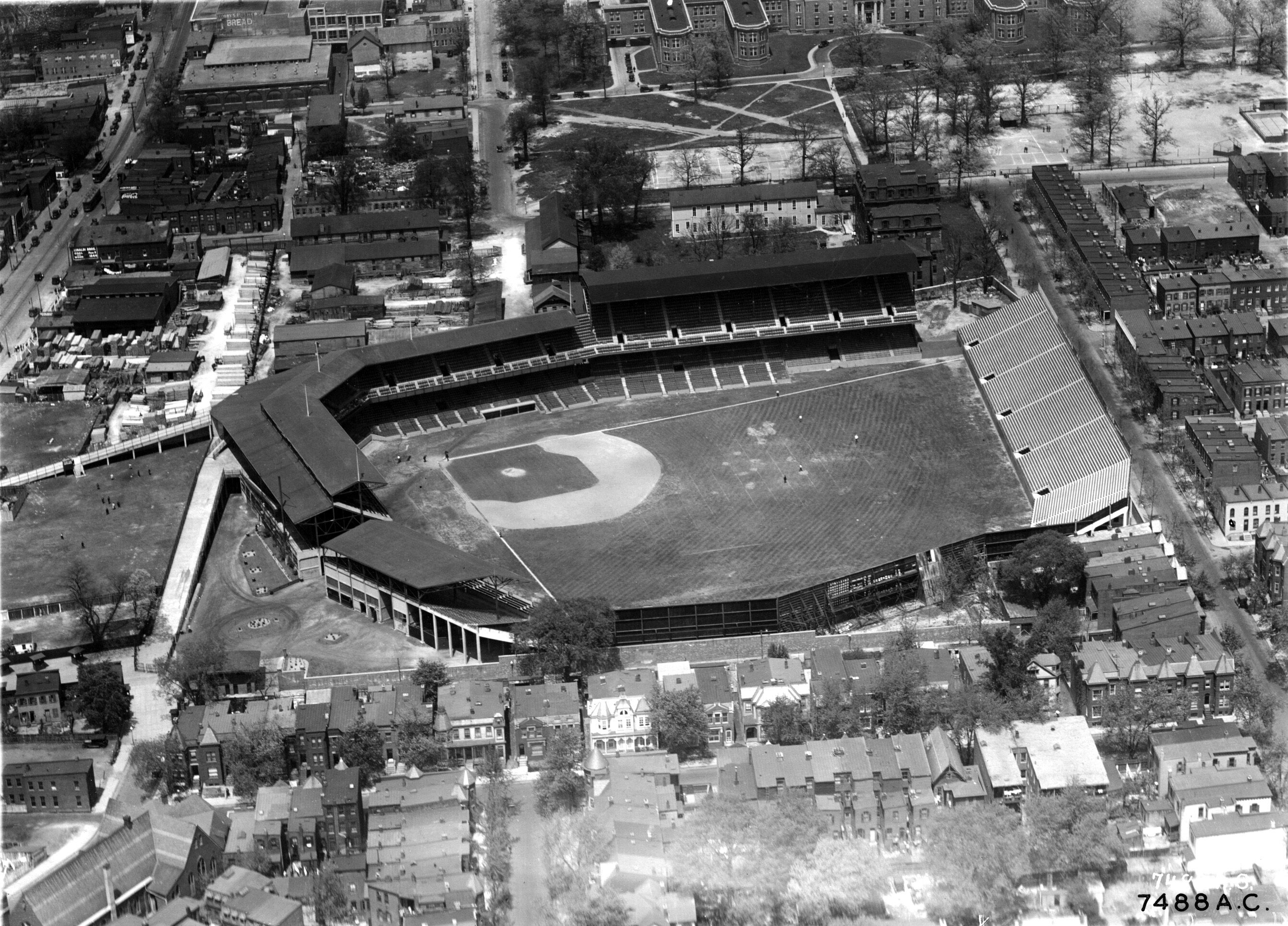
Every time I come across a photo of Griffith Stadium, which stood where Howard University Hospital now stands, I look carefully for an angle of LeDroit Park. By way of Ghosts of DC comes this superb 1925 aerial shot looking north at the stadium and part of the neighborhood.
The east-west street in the foreground is the 500 and 600 blocks of U Street NW. Zoom in and look around. Notice the streetcars on Georgia Avenue in the upper-left corner of the photo. Notice the previous incarnation of the Florida Avenue Baptist Church in the lower-left corner.
The stands beyond Griffith’s straightaway center field backed up to 5th Street from Elm to V Streets. Can you imagine hearing the crack of a bat and roar of crowds during a Senators game?
Also note what’s no longer standing. All but seven houses pictured east and north of the stadium have since been demolished, replaced with parking garages, parking lots, public housing, or academic buildings. Nearly all of these houses would be illegal to rebuild today under our 1950s zoning code, which mandates minimum lot sizes and house widths to which much of historic LeDroit Park does not conform.
Photo source: National Archives
Capital Bikeshare comes to LeDroit Park
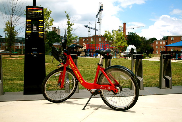
Earlier today DDOT installed LeDroit Park’s first Capital Bikeshare station. The station is located at the south entrance of the Park at LeDroit at Third and Elm Streets NW. This station fills a conspicuous hole in the city’s bikesharing map. The station was scheduled to be installed last fall, but delays from the Montréal-based supplier and confusion as to which District agency controlled the park meant that nothing happened until today.
As for the last bit of confusion, we give special thanks to residents like Mr. Hamilton and our ANC Commissioner Marc Morgan (1B01), who pushed the city to resolve the issue and install the station this month.
Here is the map with the location of the new station.
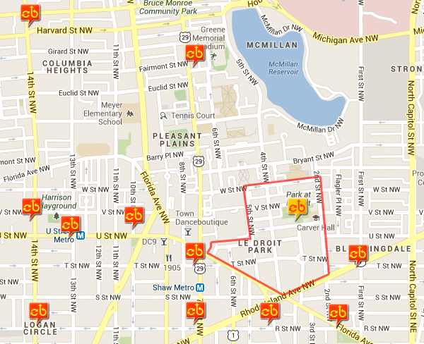
The new Capital Bikeshare station (yellow) in LeDroit Park (red outline)
LeDroit Park slated to get a Capital Bikeshare station this fall
LeDroit Park Civic Association President and ANC 1B01 candidate Marc Morgan has confirmed that our neighborhood is on the short list to receive one of the 15 new Capital Bikeshare stations this fall. The station will likely go at the Park at LeDroit on the Elm Street side.
The District and Arlington continue to buy stations and expand the system, filling in more gaps throughout the densest parts of both jurisdictions. Sure, we don’t quite match the richly bespeckled station density of Montréal or Paris, but local annual budgets include capital line items to purchase more stations.
Despite the fact the system is approaching its second birthday, many news outlets misunderstand the purpose of the system. The annual fee of $75 allows subscribers to rent the bikes at no additional charge for an unlimited number of 30-minute trips.
The 30-minute free period— there’s a charge for longer trips— is supposed to discourage riders from taking out the bikes for hours on end. In fact, the intended purpose is not joy-riding around town, but to facilitate trips that are slightly too long to walk and slightly too short for driving or transit.
For instance, I find CaBi to be to most convenient way to get between LeDroit Park and Dupont Circle. No need to wait for buses or trains, no need to transfer at Gallery Place, no need to hunt for parking.
Stations already exist near LeDroit Park, at 7th and T Streets NW and at First Street and Rhode Island Avenue NW. The new station will finally put LeDroit Park on the CaBi map.
A neighborhood listserv can be civil, too
Earlier last week a Howard student on the 400 block of Elm Street held a somewhat raucous party. Some neighbors voiced their displeasure on the neighborhood listserv. Normally this sort of event is not news, but the student’s apology on the listserv was notable:
It came to my attention that last night and possibly other nights this week, a student of Howard or I have disrupted this order of the 400 block of Elm. I would like to apologize to you for this. I did not anticipate so many people, however, I understand that it is still my responsibility. I am sending this email to assure you and the residence of Elm Street that this will not be a recurring problem, in fact, this will be the last time I cause this disturbance again. I do realize that this is a historic neighborhood and I never meant to disrespect you or any of the neighbors. This is your community, not mine. Once again I apologize and I would love to speak to you in person, maybe over lunch or coffee.
If anyone has any question, feel free to email me or if you would like to speak in person, email me and we can set up a time that works best.
Once again I apologize and I can assure you that my tenants and I will not cause this incident again
Thank you for your time
Langston W
The public apology is appreciated. However, the sentence “this is your community, not mine” was striking. A community belongs to the people who live there at that time, even residents who are also enrolled at the adjacent university.
Easter in LeDroit Park

Tulips on the 200 block of Elm Street NW
Nothing says spring like pastel tulips on a sunny Easter morning. Much to the benefit of passersby, one Elm Street resident caught tulipmania this year!
Before the park, before the school, there were apartments

The Park at LeDroit was built on the site of the Gage-Eckington School. The school, built in the 1970s, was itself built over streets, houses and apartment buildings.
At the time, 3rd Street extended north of Elm Street and dead-ended just before reaching V Street. Oakdale Place extended eastward from its current terminus at the park to dead-end at what is now the eastern boundary of the park.
Two apartment buildings on the site, the Linden and the Harewood were named after local streets. Before the city changed the neighborhood’s street names, 3rd Street was Harewood Avenue and 4th Street was Linden Street.
We found this 1901 description of the apartments. What’s most notable is that the apartments are marketed to black Washingtonians and thus reflects the neighborhood’s turn-of-the-century transition from a white neighborhood to a black neighborhood.
THE LINDEN AND HAREWOOD FLATS
Le Droit Park—Corner of Harewood and Oak Streets.
The Colored American
January 5, 1901Mr. Banes the the real estate dealer has erected two of the most modern flats in Washington situated in Le Droit Park. The situation of these flats is an ideal one, on Third street, two doors from the Fourt street car line. The finish of the flats is elegant, and they have a preposessing appearance. They are three stories high, and each floor has three flats of four rooms each and bath. The whole flat is heated by steam, thus saving the necessary expense of buying fuel. Each flat has a parlor, dinning [sic] room, bed room, kitchen, and bath room and private hall rooms, and halls are heated by steam. The kitchens have a modern gas range, hot and cold water, cupboards, pantry attachment. These flats are no doubt, the best in the city. Persons having a large family can easily rent two adjoining flats saving the enormous rent of an entire house. They are thoroughly and artistically finished. The walls are papered and frescoed, and glasses of a large size, supported by a modern mantel piece are in each parlor. Le Droit Park has become a pleasant part of Washington in which to reside and these beautiful flats are a happy addition to the residences there. Mr. Banes has spared no pains in making these flats comfortable and inviting and already applications are being made for retals thereof. Colored people with first class reference who desire a beautiful part of the city in which to live, and at the same time occupy comfortable and improved apartments without renting a whole house, and paying high rent, can find a happy medium in these flats. The terms are easy. The buildings are open daily for inspection. For further information call at the office of Mr. Charles E. Banes, corner of 14th and G sts. n. w.
“LE DROIT PARK. What Three Years Have Done.”
We came across this 1876 article documenting the initial improvements to the nascent LeDroit Park.
LE DROIT PARK. What Three Years Have Done.
National Republican
September 4, 1876Mr. James H. McGill, architect, has forwarded to the inspector of buildings, Mr. Thos. M. Plowman, a communication, in which he furnishes interesting information in relation to the improvements made in LeDroit Park within the last two years. He states that the different tracts of land composing the park were purchased at different times from June, 1872, to March, 1873, by Messrs. A.L. Barber & Co., and united by these gentlemen into one tract, which has been carefully surveyed and recorded. This park is in the form of an equilateral triangle, with one side resting on Boundary street [now Florida Avenue] and reaching from Seventh street eastward to Second street, and contains fifty acres. Until its subdivision by the present proprietor the eastern tract had been used for private residences and grounds, and the western portion had laid uninclosed for several years, and had been used as a public common. Improvements were soon commenced on a liberal scale; a handsome pattern of combination wood and iron fence was adopted and built all along the entire front and a board fence all along the rear, making one inclosure. All the interior fences were removed, and the lots thrown in together, affording a continuous sward. Streets were graded, graveled and guttered, brick sidewalks were put down, and gas, water and sewer mains laid.
The erection of buildings was commenced in July, 1873, since which time eight large brick residences have been erected on the north side of Maple avenue [now T Street] and two on the south side, costing from $4,000 to $12,000 each; ten houses on the north side and ten on the south side of Spruce street [now U Street], at an average cost of $3,500; two houses on the north side of Elm street, costing $3,000 each; four houses on east side, and five on the west side of Harewood avenue [now 3rd Street],costing from $4,000 to $10,000 each. A very superior stable and carriage-house has been completed for A. Langdon, esq., and another is in course of erection for A. R. Appleton, esq. Up to this date forty-one superior residences and two handsome stables have been constructed, at a cost of about $200,000. These houses are either built separately or in couples; are nearly all of brick; of varied designs, no two being alike either in size, shape or style of finish, or in the color of exterior. About $4,000 has been expended in the purchase and planting of ornamental shade trees and hedges, and about $50,000 in street improvements. About 4,500 lineal feet of streets have been graded and graveled, 9,000 feet of stone and brick gutters laid, 5,000 feet of brick pavement, 4,000 feet of sewer mains, 3,550 feet of water mains and 3,800 feet of gas mains laid. All of this expense has been by the proprietors of the property without a dollar from the District or authorities, and all the work has been done in the best and most liberal manner, under the direction of Mr. McGill. The plan contemplates the finishing of all its streets and the erection of two hundred tastefully-designed, conveniently-arranged and well-built detached and semi-detached residences, and when completed cannot fail of being a credit to all concerned. During the time stated the value of improvements constructed in other portions of the county amount to upwards of $100,000.
Census data for LeDroit Park
In preparation for redistricting Ward 1’s ANCs, the DC Office of Planning has released block-by-block demographic data for the District. We have combined the data for the blocks that comprise LeDroit Park to create a LeDroit Park census.
Analyzing U.S. Census data for LeDroit Park proves difficult because the of the way census tracts are drawn. Our census tract, 34, combines LeDroit Park and Howard University. Dorms on the northern end of the campus, far away from LeDroit Park, account for 717 of the tract’s 4,347 residents, thus skewing tract data. Furthermore, the tract also inclues several blocks bounded by Rhode Island Avenue NW, Florida Avenue NW, and 2nd Street NW.
Fortunately, the Census Bureau provides data for each block, allowing us to combine the statistics for those blocks in LeDroit Park, while excluding the Howard University campus. In the map below, we have outlined the tract in blue and shaded the blocks for LeDroit Park in red.
View LeDroit Park Census in a larger map
Though LeDroit Park started out as an exclusively white suburban neighborhood, by 1910 the neighborhood was almost entirely black. Today, 100 years later, the neighborhood is 70% black and is continuing to diversify.

However, when looking at the numbers on a block-by-block basis, you see that the neighborhood demography, must like that of the District itself, is unevenly distributed.
The block bounded by 5th Street, T Street, 6th Street, and U Street is 53% white, the highest in the neighborhood. Likewise, the block containing the Kelly Miller public housing is 91% black, the highest percentage in the neighborhood. The block containing the arch and the Florida Avenue Baptist Church comes closest to black-white equilibrium at 44% and 49% for each group respectively.

When looking at total population numbers for each block, you see that the two most populous blocks contain Howard University dorms. The block bounded by 2nd Street, T Street, 3rd Street, and Elm Street has 382 residents and contains Slowe Hall, which houses 299 students.
The second most populous block contains the new park. However, it also contains Carver Hall, which itself houses 173 students. Certainly these blocks are big, but the fact that their population numbers are off the chart has more to do with student dorms than with any inherent difference in housing density.

Finally, when we look at housing vacancy, we see that the block bounded by 5th Street, T Street, 6th Street and U Street has 38% of its housing units vacant. We’re not sure what’s causing this number, but we suspect that the apartment building at 5th and U Streets NW boosted the vacancy rate. The building has since been finished and is fully rented.
The block with the second-highest rate of vacancy contains the now-renovated Ledroit Place condo building at 1907 3rd Street NW.

It would be interesting too look at other data, including household income, car ownership, and age distribution for the neighborhood. However, the Office of Planning’s spreadsheet only covered population numbers, racial distribution, and housing unit numbers, so those are the metrics we graphed.
Three Projects Break Ground This Week
We’re back from our half-month vacation and LeDroit Park and Shaw are about to see some construction action starting today.
Wednesday, September 1 – 10:30 am
Just when we thought construction on the park on the site of the old Gage-Eckington School would begin, along came the parks scandal last October. Then in March, Harry Thomas Jr. (D – Ward 5) tried to prevent the mayor from appropriating money to the park project; he then reversed himself after an avalanche of constituent criticism. The new contract was ready to go until Councilmember Marion Barry (D – Ward 8) put a hold on the contract in late July. Mr. Barry’s delay procedure just expired and the mayor’s office will host a groundbreaking ceremony today at 10:30 am at Third and Elm Streets.
3:00 pm
Over in Shaw, the two block site currently occupied by Giant and a crumbling old market façade is about to start its journey to become a vibrant mixed-use development. Join the Del. Eleanor Holmes Norton (D), Mayor Adrian Fenty (D), Council Chairman Vincent Gray (D), Councilmember Jack Evans (D – Ward 2) and Councilmember Kwame Brown (D – at large) for the groundbreaking.
Thursday, September 2 – 10:45 am
After years of planning and promises, construction on the Howard Theatre begins in earnest. Join the developer, ANC Commissioner Myla Moss, and other notables for the official groundbreaking.
We’re relieved to see these long-promised projects finally moving forward to construction.
LeDroit Park Market Robbed
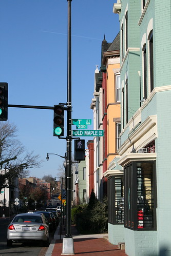 Simon’s store, the LeDroit Park Market at Fourth and T Streets NW was robbed earlier this afternoon. The suspect is described as a black man, 5′ 6″ to 5′ 7″, bearded, and wearing a green shirt, white sunglasses, a dark colored hat, blue jeans with black shoes. The neighborhood-funded surveillance camera placed on Simon’s store may have caught a glimpse of the suspect.
When Simon opened his second business, Cookie’s Corner at the corner of Second and Elm Streets NW, some decried the presence of bullet-proof glass at the counter. Does this latest robbery vindicate that decision?


Recent Comments