
Battle ensues over control of Crispus Attucks Park

Crispus Attucks Park by rockcreek, on Flickr
The Post is running an article about the battle over control of Crispus Attucks Park in Bloomingdale. The park is a hidden gem in Bloomingdale. It’s embedded in the middle of the block bounded by North Capitol Street, U Street NW, V Street NW, and First Street NW.
The park is on land once owned by C & P Telephone, but which was transferred to a non-profit in the 1970s. But who controls the non-profit that controls the park? Aye, there’s the rub.
The Lincoln vs. the Howard: What a difference operations make

The revival of the Howard Theatre brought worry that our newly revived venue would follow the disappointing path of the Lincoln Theatre on U Street. After all, both theaters were built in the early 20th century, both are owned by the DC government, and both are located within a short walk of each other.
A glance at both theaters’ online schedules reveals that their fates have sharply diverged. From now until the end of June, the Lincoln Theatre has 5 events scheduled while the Howard has 51.
This glaring disparity shows the importance of selecting the right management team. The District chose the experienced Blue Note Entertainment Group to run the Howard while it chose the non-profit U Street Theatre Foundation to run the Lincoln. The mayor’s office rightly revoked U Street Theatre Foundation’s contract for the Lincoln as the theatre was careening toward bankruptcy at the end of 2011. The mayor has tasked the DC Commission on the Arts and Humanities with finding a new operator for the Lincoln.
The greater U Street area is a regional arts venue. The Howard Theatre, the 9:30 Club, U Street Music Hall, the Black Cat, Bohemian Caverns, Twins Jazz Club, and numerous performance-oriented bars provide an amount of live performance space most cities would envy. But when we compare the success of these venues to the fiasco of the Lincoln Theatre, it becomes clear that something is terribly wrong in the District’s stewardship of this resource. If all of these venues can thrive, so can the Lincoln.
A moratorium will stifle new restaurants and lower service
We recently received a petition to oppose a liquor license moratorium for the U Street area. We weren’t sure why the petition came up, but it seems there is yet another movement afoot to establish a liquor license moratorium (and thus a restaurant moratorium) on U Street. The moratorium’s backer is a resident on 13th Street and she proposes the moratorium for all new liquor license applications within a 1,800-foot radius of Ben’s Next Door.
We wrote about this matter two years ago when Jim Graham floated the idea. Nonetheless, it’s worth revisiting why this moratorium is a bad idea:
It makes no distinction between responsible businesses and rowdy businesses.
A moratorium fails to differentiate between businesses that are quiet and cause no trouble for their neighbors, e.g. the Saloon, and those that cause raucous noise late into the night. ANCs and neighbors should protest irresponsible and disruptive businesses, but a moratorium is essentially a permanent, unconditional protest of all proposed restaurants and bars. Many new establishments are started by experienced restaurateurs whose previous businesses exist in harmony with their neighbors.
It’s effectively a restaurant moratorium.
Restaurants make their money on alcohol and relatively little on food. This is why Shaw’s Tavern, when dry, quickly shuttered. Prohibiting the issuance of new liquor licenses will essentially deny new restaurants the ability to earn enough to pay rent. A liquor license moratorium is a restaurant moratorium.
It will reduce customer service.
A moratorium will limit the supply of restaurants and bars even while demand rises. This means restaurant prices will face upward pressure, seating may become scarcer, and service quality will likely fall. The population of the census tract covering the eastern side of the U Street corridor grew by 86% from 2000 to 2010 and will continue to grow as more residential buildings come online. If you think finding a table is hard now, a moratorium will make it worse.
It unfairly “picks winners”.
Placing a legislative cap on new business activity unfairly privileges incumbent businesses. To intervene so severely in the market as to artificially limit consumer choice means that current license holders will enjoy an oligopoly. This increased business, however, will not result from a restaurant’s merit, but will result from the fact that consumers will face limited choices. A business owner’s “merit” will simply be that he had the good luck open shop just before the regulatory door slammed shut behind him.
It’s arbitrary.
There are currently 107 licenses within the proposed moratorium area. There is no definitive proof that the 107 number is too high, too low, or just right. Unfortunately, moratoria disregard nuance and set arbitrary numbers as permanent limits.
Furthermore, it’s arbitrary to propose that the moratorium be based on a perfect circle, that the circle have a 1,800-foot radius, and that the circle be centered on Ben’s Next Door.
It will not resolve the stated problem.
Matters of crime, noise, and trash, which the City Paper reports as the main motivators for the moratorium’s proponent, will not be resolved by a moratorium. Restricting the issuance of alcohol licenses will not reduce crime, will not reduce noise, and will not reduce trash. It will, however, result in longer wait times for table, higher prices, and lower service.
It’s difficult to administer.
Laws should be simple to understand and administer. The proposed moratorium area is a circle and circles are harder to measure on land. In fact, we discovered this problem recently when measuring the distance between a liquor store and Cleveland Elementary School. Do you measure by the edge of the property line or by the edge or the building? Certainly we have the technology today to determine this distance, but it takes time and skill to do it accurately. The technical challenge is a hurdle for business owners and citizens alike to understand the impact of the law. A listing of city blocks would be far easier to decipher and would cause less confusion than a circle.
* * *
Instead of swinging a legal sledgehammer to stop all future restaurants, good and bad, we should judge each application on its own merit. Restaurateurs who have proven records of being good neighbors should by all means receive licenses and less reputable restaurateurs should be denied. We urge you to sign the petition to oppose the moratorium.
7th & Florida in ’68, ’88, and today

What happened to all the historic buildings at 7th Street, Florida Avenue, and Georgia Avenue? We all recognize the CVS and its adjacent parking lot. As we reported before, the adjacent grassy field is slated for a residential development by JBG, one of the region’s largest development companies.
But how did the CVS, the parking lot, and the grassy field get there in the first place? They are the consequence of the 1968 riots and of the construction of the Green Line tunnels.
The riots of April 1968 destroyed many of the buildings along 7th Street. A few months ago we came across this photo in a Congressional report published in the wake of the riots. The west side of 7th Street from T Street to Florida Avenue was obliterated:

Decades later, the intersection sat at an elbow in the proposed Green Line tunnel. The subway line curves from 7th Street to Florida Avenue and then to U Street. Much of the line was constructed using the cut-and-cover method, which requires razing buildings, digging a trench, building a concrete box in the trench, and covering it back over.
Subway tunnels typically run under existing streets, but sharp changes in direction require cutting corners and thus the creation of tunnels where buildings often stand.
A 1988 photograph shows the construction of the Green Line tunnels, which pass under the CVS and adjacent lots.

What the riots didn’t destroy, the Green Line took care of.
Neighborhood history trail nearly complete
 LeDroit Park and Bloomingdale history buffs need to mark their calendars for Thursday night. The LeDroit Park-Bloomingdale Heritage Trail Working Group will meet to go over updates to the pending bi-neighborhood heritage trail.
You’ve seen these heritage trails elsewhere in Washington. The signs feature historical photographs and explanations of the areas’ historical significance.
At the last meeting we attended, we heard from residents who lived in the neighborhood that stood where the Gage-Eckington School was later built, neighbors who had to walk several extra blocks to school because Washington ran a segregated school system, and neighbors who remember seeing Eleanor Roosevelt visiting what is now Slowe Hall at 3rd and U Streets.
These are the oral histories that Cultural Tourism, which organizes these trails, documents for the historical record and includes in the signs. So much of Washington’s history, nay human history, is committed to memory that if we don’t record it, it risks being lost.
The trail, which is put together by Cultural Tourism DC, is close to completion, but the next few meetings are critical in determining final details and extra stories that may be incorporated. Even if you don’t have stories or original research to contribute, attending the meeting solely to listen will be worthwhile.
Thursday, April 19 at 7 pm
St. George’s Church (basement)
2nd & U Streets NW
44 year ago today, Washington burned
A neighbor pointed us to this poignant video footage of the riots that occurred 44 years ago here in Washington after the assassination of Dr. Martin Luther King.
Contrary to popular belief, suburban flight and urban disinvestment were already well-underway by 1968. The destruction that occurred in American cities that year was not the cause of urban decay; it merely accelerated a pre-existing, post-war urban decline. Most middle-class Americans, regardless of race, do not want to live or shop in a war zone, after all. Thus DC’s commercial districts quickly declined.
The riots that year were a mixed result: they meaningfully displayed frustration at systematized racism in American society, but they also destroyed the essential businesses in DC’s majority-black neighborhoods.
The sociology of the matter is controversial, but it’s important we review accounts of the history just to know what happened.
Look carefully at video and you’ll recognize 7th Street in Shaw, U Street, and 14th Street. Washington was never the same after April 1968.
Will the Howard Theatre go the same way as the Lincoln Theatre?

The Lincoln by M.V. Jantzen, on Flickr

Howard Theatre. Photo by the author.
Will the Howard Theatre, soon to open in April, end up bankrupt like the Lincoln Theatre on U Street? Both are historic U Street area theaters that were revived at significant public expense. Both are owned by the District government and are under the control of non-profits.
There are, however, some significant differences between the Lincoln and the Howard: the floor, the kitchen, and the management.
The Lincoln Theatre is a traditional theater with fixed rows of seats. This makes the venue unsuitable for a variety of performances. All concert venues nearby have few if any seats— just an open floor where patrons stand.
The Howard Theatre’s floor is a little different. The theatre will have few permanent seats. Much of the space will contain seats and tables for the performances where food is served, such as the weekly gospel brunch, a comedy show, or certain jazz performances.
When tables are unsuitable for the type of performance, they will be stowed beneath the stage, thus opening up the first floor like the 9:30 Club or the Black Cat. This flexibility allows the venue to attract a greater variety of acts.
Another important difference is that the Howard Theatre will contain a large kitchen. Food service, particularly on the sale of alcohol, is where the venue will make money. The Lincoln Theatre’s food and liquor operation can’t compare.
Finally, while the Lincoln Theatre was managed (or mismanaged, some say) by an ad hoc non-profit, the Howard Theatre will be run by Blue Note Jazz Clubs, which runs the Blue Note Jazz Club, the Highline Ballroom, and B.B. King Blues Club & Grill in New York. This gives us confidence that a similar success can happen at the Howard.
Howard still owns a few properties in LeDroit Park
In reviewing Howard University’s proposed campus plan, we started to take account of all of the property in DC that the university owns. Up until 10 years ago, Howard University was accused of being LeDroit Park’s biggest slumlord, owning numerous properties in the neighborhood and letting them lie vacant, blighted, and decaying.
Under the reign of university president H. Patrick Swygert, Howard made a significant and commendable effort to rehab and sell many of its vacant properties in the neighborhood.
For instance, the university owned all but one house on 400 block of Oakdale Place. It let these houses lie vacant, blighted, and boarded up. Under Pres. Swygert, the university renovated the houses and sold them to employees. Today the 400 block of Oakdale Place is fully occupied and a new condo building is nearing completion on the western end.

531 & 533 U St NW in 2004. Howard University renovated 531 (right) in 2004. Image from the DC government.
In other cases, the university renovated properties but has retained ownership. 531 U Street NW looked terrible in 2004 (right), but now looks very nice. We can’t quite tell if the house is occupied, but it consistently appears to be in good condition.
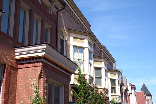
Elsewhere on the 500 and 600 blocks of U Street, Howard built historic infill houses (below) on vacant lots it owned on the north side of the street. The result is a block with with a continuous wall of housing on the street’s northern face. The houses’ façades are of high quality, with detailed brick work, ornate porches, and a variety of detailing.
The job is not entirely done, however, and Howard University retains ownership of a few properties that raise eyebrows. Let’s look at these three:

649 Florida Avenue (left) sits as a vacant lot, frequently collecting trash and debris. A university official told us that long ago Howard had considered using the lot to create a delightful pedestrian path to the university from the Shaw Metro. That never happened and now the lot sits vacant.
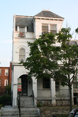
408-410 T Street (center) was the home of Walter Washington, DC’s first elected mayor. The university owns the property, and though it’s not blighted, it may be vacant. With some renovation work, this would make an excellent rental home for a Howard professor or anyone else for that matter.
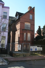
326 T Street (right) is the Mary Church Terrell House, future home of the Robert and Mary Church Terrell House & LeDroit Park Museum and Cultural Center. Though it’s vacant and undoubtedly meets the District’s definition of blight, we are willing to cut the university more slack in this case since the eventual outcome will be a wonderful addition to the neighborhood. Unfortunately, the campus plan does not specify any additional Howard funding to restore the site.
In addition to the properties above, Howard owns a few more properties in LeDroit Park:
- Gravel parking lot at the SE corner of 5th and W Streets. (Square 3072, Lot 818). Campus plan does not mention any change to this lot.
- Carver Hall, 211 Elm St NW (Square 3084, Lot 830). Campus plan mentions the dorm’s decommission, but no reuse plans.
- Slowe Hall, 1919 3rd St NW (Square 3088, Lot 835). Campus plan mentions the dorm’s decommission, but no reuse plans.
- Howard University Hospital daycare, 1907-11 5th St NW (Square 3090, Lot 41)
- 420 T St NW – a house that appears to be occupied (Square 3094, Lot 800)
- Howard University Hospital (Square 3075, Lot 807)
- Parking garage bounded by 4th St, Oakdale Pl, 5th St, and V St. (Square 3080, Lot 73)
- Parking garage bounded by 4th St, V St, 5th St, and an alley. (Square 3072, Lot 52)
Though Howard retains a few problematic properties, it’s important to note the great strides the university has made in taking responsibility for its property portfolio in the neighborhood. A plan for these few remaining properties, even one in which the university retains ownership but leases, would put residents at greater ease.
“LE DROIT PARK. What Three Years Have Done.”
We came across this 1876 article documenting the initial improvements to the nascent LeDroit Park.
LE DROIT PARK. What Three Years Have Done.
National Republican
September 4, 1876Mr. James H. McGill, architect, has forwarded to the inspector of buildings, Mr. Thos. M. Plowman, a communication, in which he furnishes interesting information in relation to the improvements made in LeDroit Park within the last two years. He states that the different tracts of land composing the park were purchased at different times from June, 1872, to March, 1873, by Messrs. A.L. Barber & Co., and united by these gentlemen into one tract, which has been carefully surveyed and recorded. This park is in the form of an equilateral triangle, with one side resting on Boundary street [now Florida Avenue] and reaching from Seventh street eastward to Second street, and contains fifty acres. Until its subdivision by the present proprietor the eastern tract had been used for private residences and grounds, and the western portion had laid uninclosed for several years, and had been used as a public common. Improvements were soon commenced on a liberal scale; a handsome pattern of combination wood and iron fence was adopted and built all along the entire front and a board fence all along the rear, making one inclosure. All the interior fences were removed, and the lots thrown in together, affording a continuous sward. Streets were graded, graveled and guttered, brick sidewalks were put down, and gas, water and sewer mains laid.
The erection of buildings was commenced in July, 1873, since which time eight large brick residences have been erected on the north side of Maple avenue [now T Street] and two on the south side, costing from $4,000 to $12,000 each; ten houses on the north side and ten on the south side of Spruce street [now U Street], at an average cost of $3,500; two houses on the north side of Elm street, costing $3,000 each; four houses on east side, and five on the west side of Harewood avenue [now 3rd Street],costing from $4,000 to $10,000 each. A very superior stable and carriage-house has been completed for A. Langdon, esq., and another is in course of erection for A. R. Appleton, esq. Up to this date forty-one superior residences and two handsome stables have been constructed, at a cost of about $200,000. These houses are either built separately or in couples; are nearly all of brick; of varied designs, no two being alike either in size, shape or style of finish, or in the color of exterior. About $4,000 has been expended in the purchase and planting of ornamental shade trees and hedges, and about $50,000 in street improvements. About 4,500 lineal feet of streets have been graded and graveled, 9,000 feet of stone and brick gutters laid, 5,000 feet of brick pavement, 4,000 feet of sewer mains, 3,550 feet of water mains and 3,800 feet of gas mains laid. All of this expense has been by the proprietors of the property without a dollar from the District or authorities, and all the work has been done in the best and most liberal manner, under the direction of Mr. McGill. The plan contemplates the finishing of all its streets and the erection of two hundred tastefully-designed, conveniently-arranged and well-built detached and semi-detached residences, and when completed cannot fail of being a credit to all concerned. During the time stated the value of improvements constructed in other portions of the county amount to upwards of $100,000.
Census data for LeDroit Park
In preparation for redistricting Ward 1’s ANCs, the DC Office of Planning has released block-by-block demographic data for the District. We have combined the data for the blocks that comprise LeDroit Park to create a LeDroit Park census.
Analyzing U.S. Census data for LeDroit Park proves difficult because the of the way census tracts are drawn. Our census tract, 34, combines LeDroit Park and Howard University. Dorms on the northern end of the campus, far away from LeDroit Park, account for 717 of the tract’s 4,347 residents, thus skewing tract data. Furthermore, the tract also inclues several blocks bounded by Rhode Island Avenue NW, Florida Avenue NW, and 2nd Street NW.
Fortunately, the Census Bureau provides data for each block, allowing us to combine the statistics for those blocks in LeDroit Park, while excluding the Howard University campus. In the map below, we have outlined the tract in blue and shaded the blocks for LeDroit Park in red.
View LeDroit Park Census in a larger map
Though LeDroit Park started out as an exclusively white suburban neighborhood, by 1910 the neighborhood was almost entirely black. Today, 100 years later, the neighborhood is 70% black and is continuing to diversify.

However, when looking at the numbers on a block-by-block basis, you see that the neighborhood demography, must like that of the District itself, is unevenly distributed.
The block bounded by 5th Street, T Street, 6th Street, and U Street is 53% white, the highest in the neighborhood. Likewise, the block containing the Kelly Miller public housing is 91% black, the highest percentage in the neighborhood. The block containing the arch and the Florida Avenue Baptist Church comes closest to black-white equilibrium at 44% and 49% for each group respectively.

When looking at total population numbers for each block, you see that the two most populous blocks contain Howard University dorms. The block bounded by 2nd Street, T Street, 3rd Street, and Elm Street has 382 residents and contains Slowe Hall, which houses 299 students.
The second most populous block contains the new park. However, it also contains Carver Hall, which itself houses 173 students. Certainly these blocks are big, but the fact that their population numbers are off the chart has more to do with student dorms than with any inherent difference in housing density.

Finally, when we look at housing vacancy, we see that the block bounded by 5th Street, T Street, 6th Street and U Street has 38% of its housing units vacant. We’re not sure what’s causing this number, but we suspect that the apartment building at 5th and U Streets NW boosted the vacancy rate. The building has since been finished and is fully rented.
The block with the second-highest rate of vacancy contains the now-renovated Ledroit Place condo building at 1907 3rd Street NW.

It would be interesting too look at other data, including household income, car ownership, and age distribution for the neighborhood. However, the Office of Planning’s spreadsheet only covered population numbers, racial distribution, and housing unit numbers, so those are the metrics we graphed.


Recent Comments