
Coffeehouse Coming to Florida Avenue
At tomorrow’s monthly meeting of ANC1B, representatives for a fledgling coffeehouse/lounge, The Independent (715 Florida Avenue NW), will petition for a Class C liquor license. The Independent seeks to serve beer, wine, and liquor to a maximum of 235 people (199 seats) on the first floor and a maximum of 90 people (75 seats) in the summer garden. They propose these hours:
| Sun | Mon | Tue | Wed | Thu | Fri | Sat | |
|---|---|---|---|---|---|---|---|
| Open | 7am | ||||||
| alc. served | 10am | 8am | |||||
| last call & close | 2am | 3am | |||||
Entertainment will run 6pm – 2am (Sun. – Thurs.) and 6pm – 3 am (Fri. and Sat.).
Up at 2632 Georgia Avenue, GII Restaurant & Lounge plans to host acoustic jazz bands, karaoke, open mike nights, and DJs to a maximum of 102 people (86 seats). They propose the following business hours: 6 am-2:30 am (Mon. – Wed.) and 6 am-3 am (Thurs. – Sun.). The propose serving alcohol 10 am-2 am (Sun.), 8 am-2 am (Mon. – Thurs.) and 8 am-3 am (Fri. and Sat.). Entertainment will be 6 pm-2:30 am (Mon. – Wed.) and 6 pm – 3 am (Thur. – Sun.).
Here in LeDroit Park, the Elks Lodge at 1844 Third St seeks to renew its license but not without controversy. In April 2008 the lodge was the site of a triple-stabbing and just a few months ago, the lodge was delinquent in paying license fines.
In addition to the lodge, the following restaurants seek to renew their licenses:
- Alero Lounge, 1301 U Street, Class C
- Crème Café & Lounge, 1322 U Street, Class C
- Little Ethiopia Restaurant, 1924 Ninth Street, Class C
- Portico, 1914 Ninth Street, Class C
- Mesobe Restaurant and Delimarket, 1853 Seventh Street, Class C
As usual, the ANC meeting will be held tomorrow (Thursday) at 7 pm on the second floor of the Reeves Building at Fourteenth and U Streets.
Shaw Fits and Starts

Broadcast Center One as viewed from the CVS at 7th & T Streets
When climbing the escalator out of the Shaw Metro’s north entrance, one emerges between Seventh Street on the left and a vacant field on the right. The vacant field has been set for renewal with a plan going back several years. In January, when we first started writing about the project, Radio One was still planning to move its headquarters to the site and the United Negro College Fund (UNCF) was considering space there, too.
At the February ANC1B meeting, the development team’s lawyer stated that the combination of UNCF and Radio One would require a reduction in the number of apartments from 180 to 133. With Radio One unceremoniously backing out, the number is now restored to 180. In January, the amount of retail space was reported to be 22,000 square feet. Now that UNCF plans to occupy 5,000 square feet on the ground floor for an outreach center, the retail component may have changed.
Two weeks ago we reported that Radio One had snubbed Shaw and decided to stay put in Lanham, possibly putting the project in jeopardy. Luckily, UNCF, in offering to purchase half of the 100,000 square feet of office space, provides a sufficient commitment to get the project further financing.
The following table illustrates the changes in the project since the beginning of the year and reflects numbers gleaned from various sources.
| Radio One | Radio One + UNCF | UNCF | |
|---|---|---|---|
| Office Space (sq ft) | 96,000 | 160,000 | 100,000 |
| Housing units | 180 | 133 | 180 |
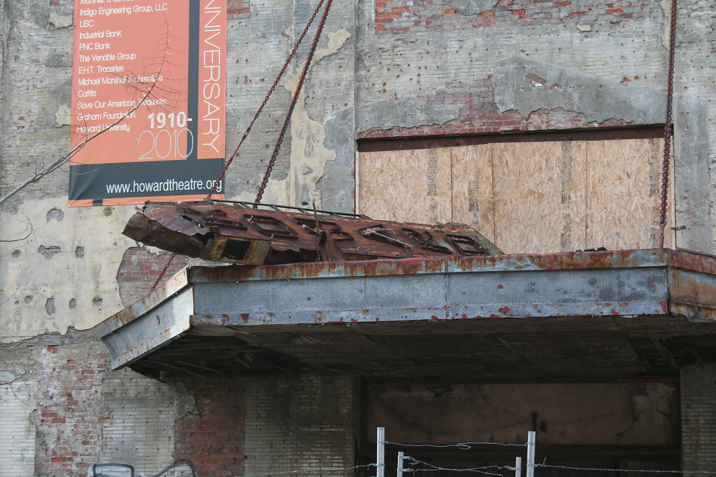
On Friday, the WBJ reported that UNCF’s chief had formally testified before the D.C. Council seeking a $3.8-million property tax break and a $710,000 grant to move to Shaw. LeDroit Park’s ANC commissioner Myla Moss (ANC1B01) testified in support of the legislation, which will be taken up by the full council in April. If approved, the development team promises (yet again) to break ground in August.
One casualty of the proposed move is the Howard Theater, already delayed and crumbling under the elements. The $710,000 relocation grant would come from money set aside for the theater’s revival.
Old Maps: The District Before LeDroit Park (1792 – 1859)
This is the first in a series of posts about historic maps of LeDroit Park.
When the Federal Government established the national capital, it was to be located within a 100-square-mile diamond straddling both sides of the Potomac. In fact, the City of Washington was just one of several established cities and settlements in the nascent Federal District, later called the District of Columbia. The City of Washington, as defined by Congress and Peter L’Enfant’s plan, was bounded by the Potomac River and Rock Creek to the west, the Anacostia River to the south and east, and by Boundary Street (now Florida Avenue) to the north. LeDroit Park sits just north of Florida Avenue, in what was originally the rural Washington County, District of Columbia. The District also included the City of Georgetown, the City of Alexandria, and Alexandria County (now Arlington County, Virginia).
The map below, dating from 1792, was the first printed version of the L’Enfant Plan (as amended by Andrew Ellicott) for the City of Washington. Notice that its northern boundary coincides with what is now Florida Avenue. LeDroit Park now sits just to the west of what is marked as “Tiber Creek”. The creek, also called Goose Creek before the founding of the city, originally ran between First and Second Streets NW through Bloomingdale all the way to what is now Constitution Avenue NW, and westward toward the Washington Monument grounds, where it emptied into the Potomac River. Much of the creek is now buried in pipes beneath the city.
 Download the full version of this map from the Library of Congress
(We have a reliable method of identifying the future LeDroit Park on old maps of Washington: look for New Jersey Avenue NW, which runs diagonally to the northwest from the Capitol. Directly north of where it ends at the city’s border is where LeDroit Park would later be built.)
The capital city grew slowly over the coming decades with new residents, including government workers and Members of Congress, housed in newly constructed houses and boarding houses near the White House and Capitol, respectively. The difficulty in finding enough skilled labor to build a capital city required the leasing of slaves, who were instrumental in constructing many of the grand public buildings that stand today.
It would be a mistake to look at the map above and assume that all the new streets and canals were built together. In fact, the L’Enfant Plan was just that, a plan. The grand, spacious avenues required the clearing of trees and brush after a tedious survey to match the ground with the map.
In fact, by 1842 so much of the city was incomplete that a visiting Charles Dickens belittled Washington as a “city of magnificent intentions” marked by
spacious avenues, that begin in nothing and lead nowhere; streets, mile-long, that only want houses, roads, and inhabitants; public buildings that need but a public to be complete; and ornaments of great thoroughfares, which only lack great thoroughfares to ornament.
Whereas the global financial markets of today allow developers to develop large tracts of land at once, 19th-century cities had to be built piecemeal with speculation limited to small projects. LeDroit Park was no different: only several houses and only a few streets were built at first with the rest to come later.
From 1856 to 1859, German cartographer Albert Boschke charted the District hoping to sell his maps to the U.S. Government. His 1859 map of the City of Washington (below) provided illustrative evidence supporting Charles Dickens’s sneer. Much of Washington, especially its northern reaches near what was to become LeDroit Park, sat undeveloped with only a few cleared streets.
") Download the full version of this map from the Library of Congress. To aid orientation, we have superimposed a few street names.
Download the full version of this map from the Library of Congress. To aid orientation, we have superimposed a few street names.
The only clear north-south street was Seventh Street, which connected the city with the rural county and stretched into Maryland (albeit under different names). At R Street— if one could call it a street— it crossed an open creek that ran through the right-of-way.
Seventh Street’s primacy as the main north-south thoroughfare actually contradicts the intention of the L’Enfant Plan, whose Baroque determination to provide a “reciprocity of sight“, plotted Eighth Street, not Seventh Street, as the more important axis. In fact to this day the right-of-way of Eighth Street is fifteen feet wider than those of Seventh and Ninth Streets, even though Eight carries only a fraction of the traffic burden that the parallel streets carry.
It is difficult to enforce one artistic vision on a democracy; the shifting of axes, from Eighth to Seventh, merely reflects the fact that cities are shaped by their inhabitants in ways the founders never anticipate. The future LeDroit Park was no different.
Next: Alfred Boschke maps the entire District and a future LeDroit Park resident prints it, only to have it seized at gunpoint.


Recent Comments