
Bikeshare expansion passes over LeDroit Park
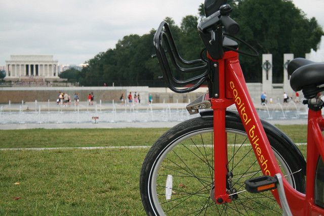
Capital Bikeshare, the District’s smashingly successful bikesharing system, will expand this fall. Unfortunately, the expansion plans for this fall exclude LeDroit Park.
The District and Arlington launched the system a year ago with 14 stations in Arlington and 100 in the District. This fall, DDOT will add 34 stations in the District. In our area, DDOT will add a station by the Shaw Library and another at 1st Street NW and Rhode Island Avenue NW in Bloomingdale.
These additions should help alleviate the pressure placed on the existing stations at 7th & T Streets NW in Shaw and at Florida Avenue and R Street NW in Bloomingdale. Currently, LeDroiters and Bloomingdalers compete to use these two stations and thus frequently leave the stations empty or full during rushhour.

Last week DDOT Director Terry Bellamy announced that the district will add 50 stations early next year. We hope that in this new round DDOT focuses more attention on LeDroit Park and other neighborhoods in ANC 1B.
For instance, a Capital Bikeshare station could easily go in at the Park at LeDroit’s south entrance at 3rd and Elm Streets NW. This location is central to the neighborhood and could bring some extra eyes to the park throughout the day.
Outside of LeDroit Park, there is a noticeable station gap in the northern reaches of Bloomingdale and around Cardozo High School.
Capital Bikeshare is particuarly successful in our part of DC for several reasons:
- Car ownership is relatively low compared to the rest of the nation, region, and city. This inclines people to bike more.
- Parking is particularly difficult on many neighborhood streets, thus making cycling more attractive.
- The historical development of this area has permitted the close proximity of commercial uses to residential uses. This means trips to shops and restaurants are short and easily made by bike.
- Downtown is a short ride away and biking is often faster than taking the bus.
“LE DROIT PARK. What Three Years Have Done.”
We came across this 1876 article documenting the initial improvements to the nascent LeDroit Park.
LE DROIT PARK. What Three Years Have Done.
National Republican
September 4, 1876Mr. James H. McGill, architect, has forwarded to the inspector of buildings, Mr. Thos. M. Plowman, a communication, in which he furnishes interesting information in relation to the improvements made in LeDroit Park within the last two years. He states that the different tracts of land composing the park were purchased at different times from June, 1872, to March, 1873, by Messrs. A.L. Barber & Co., and united by these gentlemen into one tract, which has been carefully surveyed and recorded. This park is in the form of an equilateral triangle, with one side resting on Boundary street [now Florida Avenue] and reaching from Seventh street eastward to Second street, and contains fifty acres. Until its subdivision by the present proprietor the eastern tract had been used for private residences and grounds, and the western portion had laid uninclosed for several years, and had been used as a public common. Improvements were soon commenced on a liberal scale; a handsome pattern of combination wood and iron fence was adopted and built all along the entire front and a board fence all along the rear, making one inclosure. All the interior fences were removed, and the lots thrown in together, affording a continuous sward. Streets were graded, graveled and guttered, brick sidewalks were put down, and gas, water and sewer mains laid.
The erection of buildings was commenced in July, 1873, since which time eight large brick residences have been erected on the north side of Maple avenue [now T Street] and two on the south side, costing from $4,000 to $12,000 each; ten houses on the north side and ten on the south side of Spruce street [now U Street], at an average cost of $3,500; two houses on the north side of Elm street, costing $3,000 each; four houses on east side, and five on the west side of Harewood avenue [now 3rd Street],costing from $4,000 to $10,000 each. A very superior stable and carriage-house has been completed for A. Langdon, esq., and another is in course of erection for A. R. Appleton, esq. Up to this date forty-one superior residences and two handsome stables have been constructed, at a cost of about $200,000. These houses are either built separately or in couples; are nearly all of brick; of varied designs, no two being alike either in size, shape or style of finish, or in the color of exterior. About $4,000 has been expended in the purchase and planting of ornamental shade trees and hedges, and about $50,000 in street improvements. About 4,500 lineal feet of streets have been graded and graveled, 9,000 feet of stone and brick gutters laid, 5,000 feet of brick pavement, 4,000 feet of sewer mains, 3,550 feet of water mains and 3,800 feet of gas mains laid. All of this expense has been by the proprietors of the property without a dollar from the District or authorities, and all the work has been done in the best and most liberal manner, under the direction of Mr. McGill. The plan contemplates the finishing of all its streets and the erection of two hundred tastefully-designed, conveniently-arranged and well-built detached and semi-detached residences, and when completed cannot fail of being a credit to all concerned. During the time stated the value of improvements constructed in other portions of the county amount to upwards of $100,000.
1968 riots at 7th & T Streets NW
This is the third in a series on the Scurlock photo archive. Read the others.
The 1968 riots burned and economically destroyed many commercial districts throughout Washington. Riots came to U Street, too, and several properties which were obliterated have not entirely recovered from the devastation.
After World War II, many of America’s cities faced population and economic decline as the nation suburbanized; Washington was certainly no exception. The retail corridors on 14th St NW, U St NW, and H St NE were already declining when riots hit American cities in 1968 following the Martin Luther King’s assassination.
Addison Scurlock (1883-1964) was Washington’s most prominent black photographer and when the riots started in April 1968, Mr. Scurlock[‘s sons, who inherited his studio] at 9th and U Streets (where Nellie’s now stands) knew that [they were]he was witnessing history in the making. Mr. Scurlock The Scurlocks photographed rioters at the beginning of the riots and photographed some of the aftermath.
The corner of 7th Street, Florida Avenue, and Georgia Avenue suffered from the mayhem. The southwest corner now houses a CVS and a parking lot on land that Howard University owns. Beneath this store runs the Metro tunnel between the Shaw and U Street stations. Back in 1968, this site featured a strip of retail stores until the riot.
One of the most striking Scurlock photos is of the northwest corner of 7th and T Streets NW, where the CVS currently stands. Rioters burned the buildings that stood on the site.
[Toggling between now and then photos will not work in RSS readers. View the actual post]
7th & T was always the seedier end of the U Street corridor
This is the second in a series on the Scurlock photo archive. Read the first entry.
During the Jazz Age of the 1920s and later into the 1930s, U Street was dubbed the “black Broadway” as it featured such venues as the Lincoln Colonnade (now the Lincoln Theater), the Howard Theatre, and other clubs and restaurants. In a segregated city in which blacks were excluded from most restaurants, theaters, and stores, U Street served as a refuge to catch a show and enjoy a meal.
This photo from the Scurlock archives was taken looking east at 7th and T Streets NW in 1939.
[Toggling between now and then photos will not work in RSS readers. View the actual post]
We have referred to this area as the block of blight for its dilapidated buildings, copious litter, and frequent police arrests. It turns out that some things never change. Even when this photograph was taken, U Street was not uniform in character and the area around the Howard Theatre was considered downscale compared to the classier venues west on U Street. (For more on U Street’s evolution, see Blair Ruble’s recent book, Washington’s U Street: A Biography.)
Pictured here at the corner is National Grill, which, like Harrison’s Café in LeDroit Park, advertised itself as open all night. The lighted vertical sign attached to the façade appears to read “LUNCH” and the pediment at the cornice bears the building’s name, “Scott’s”. (View a larger version of the photo.)
Just to the right (south) of National Grill is the S.W. Keys Luncheonette, whose vertical sign advertises coffee and waffles. Just south of that is Harlem Cafe, located in a building that has since been replaced.
On T Street, just behind Scott’s Building and just before the Howard Theatre, you will see a sign that reads “BILLIARDS”. That marks Frank Holliday’s pool hall, a popular gathering spot for Howard scholars, jazz musicians, and city laborers alike. Duke Ellington captured the scene at the pool hall:
Guys from all walks of life seemed to converge there: school kids over and under sixteen; college students and graduates, some starting out in law and medicine and science; and lots of Pullman porters and dining-car waiters.
Just beyond the pool hall, you’ll see the Howard Theatre sporting its original Italianate façade. The theater was later covered with plaster, which was only recently removed for the restoration project.
Today the last two buildings on 7th Street are a Chinese take-out and a tiny market. One of the developers of Progression Place, the large development project underway on the block (rendering below), said that the late owner of these two buildings refused to sell to his development. Progression Place will incorporate every building on this block except for these two.
If anyone is looking for a two-building restoration project, here is your chance!

Progression Place will include all but the gray and orange buildings.
Sharing in LeDroit Park
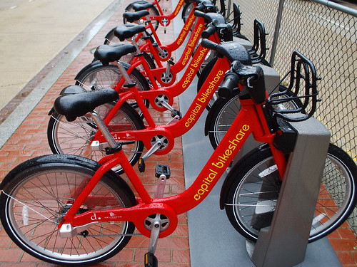
Construction is still moving along at the park on the site of the former Gage-Eckington School. In addition to the dog park, playground equipment, picnic tables, and field, there are two more amenities on their way to the site: bike sharing and car sharing. DDOT’s assistance in integrating both car sharing spaces and its own Capital Bikeshare (CaBi) system is a good example of collaboration between different city agencies.
ZipCar is a subscription service that places cars throughout several cities worldwide and rents the cars to members by the hour. The rental fee includes the cost of gas and insurance and each car has a reserved “home” parking space to which it must be returned at the end of the reservation. These spaces are in public streets, public alleys and in private parking lots and garages.
We occasionally rent ZipCars when we need to haul heavy items or need to travel to transit-inaccessible destinations. This arrangement is far cheaper than owning a car and relieves us of the normal hassles of car ownership, e.g. parking, maintenance, washing, fuel costs, and insurance costs.
CaBi is another subscription service and is a joint venture between DDOT and Arlington County. CaBi bikes are parked at numerous racks throughout DC and Arlington and more are on the way. A member inserts his key into the bike dock and the bike unlocks. The member has 30 minutes to ride the bike for free before returning it to any dock in DC or Arlington. CaBi is perfect for short one-way trips and we routinely use the CaBi station at Seventh and T Streets to commute to work downtown. It’s also useful for occasional trips to Whole Foods or Dupont Circle, which are just minutes away by bike.
Both bike sharing and car sharing benefit residents who don’t even use the services. The existence of these services reduces the pressure to own a car and thus reduces the parking demand placed on our streets. For those who would live car-less regardless of these services, it provides us with two more mobility options located close to home. Bike sharing and car sharing are welcome additions to the park site.
Photo: “Pick a Bike” by M. V. Jantzen
Robbery in Shaw
This email came through the neighborhood listserv.
On Saturday evening at 7pm en route to Shaw metro north entrance, I was jumped from behind and wrestled to the ground by a teenage thief trying to steal my iphone. Rather than risk being stabbed, I let go of the iphone. What is disturbing is that this is a busy road with many pedestrians walking by, yet not one person stopped to help, including the shopkeepers stood on the doorsteps. When I asked for assistance, I was told to use the payphone on the corner of 7th and T which is where the gang of teenagers preying on their victims hang out in the evening – including the evening I was attacked. There were 10 or 12 on the corner of 7th and T and all fled after I was robbed. A good Samaritan let me use his cellphone to call the police who arrived in under two minutes. They said they are aware of the gang on 7th and T and have been monitoring them, yet the brazen robberies and attacks in broad daylight continue unabated.
Given the proximity to the Howard Theater, I’m sure this kind of publicity will not be welcomed given the Theater’s planned reopening later this year. I have now been forced to avoid the Shaw metro and will take the U Street Cordoza location instead. Anyone walking in the vicinity of 7th and T should hide their cellphones. Ironically, I am a playwright, my most recent work being about race relations in DC. It is poignant I was attacked in the shadow of Howard Theater.
What a terrible incident, but we’re glad nobody was hurt.
The Block of Blight (600 block of T Street NW) is a perennial source of criminality, as confirmed by the MDP’s regular listing of arrests. The frequency of crime at the corner of Seventh and T Streets warrants a more frequent police presence that the area lacks.
We usually walk our friends to the Metro late at night lest they fall victim to this sort of incivility. Blight encourages crime and both are on display near the Shaw Metro Station. We gently, but consistently, remind visitors that the station and surrounding blight are actually in the Shaw neighborhood, not LeDroit Park, but hopefully we won’t have to reiterate that nuance forever.
Renovations on the Howard Theatre have already begun and the developer for the mixed-use UNCF project at the Metro assures us that the groundbreaking for that project is a month or two away.
How LeDroit Park Came to be Added to the City
The following is a Washington Times article from 1903. The article explains some of the early history of the neighborhood and even includes three photos, the first of which was misidentified as Fifth Street, though we have actually matched it up with Second Street. We have included a few links to related information.

Second Street opposite the Anna J. Cooper House.
HOW LE DROIT PARK CAME TO BE ADDED TO THE CITY
Washington Times
Sunday, May 31, 1903For Many Years the Section of Washington Known by That Name Had Practically Its Separate Government and Had All the Characteristics of a Country Town, Although Plainly Within the Boundary Limits. * * *
In that portion of Florida Avenue between Seventh Street and Eighth Streets northwest where the street cars of the Seventh Street line and the Ninth Street line pass over the same tracks, thousands of passengers are carried every day, and probably but a few if any realize the fact that they are passing over a road older than the organization of the city, a road that dates back to the Revolutionary period— the Bladensburg Road, which connected Georgetown with Bladensburg before the location of the National Capital was determined.
The Map on the Wall.
If the people passing this point will note the little frame building occupied by a florist, 713 Florida Avenue northwest, they will observe that in front of these premises and fastened to the blacksmith shop adjoining is a goodly sized signboard on which is painted an old map of this section and showing the intersection of the old Blandensburg Road and Boundary Street, now known as Florida Avenue. From this map it is seen that Seventh Street Road [now Georgia Avenue] intersects Boundary Street and the old Bladensburg Road at a point about 100 feet east of where the two roads join at an acute angle, and glancing along the lines of Boundary Street and the north lines of some buildings which have been erected in this angle we easily see the direction of the Bladensburg Road and discover that the small building 713 Florida Avenue northwest marks the spot where the Bladensburg Road deflected from Boundary Street and bore off in a northeasterly direction toward Bladensburg.
Once Part of Jamaica Vacancy.
The map referred to is said to be a portion of [the estate named] Jamaica and and Smith’s Vacancy, but if we examine the plats in the office of the Surveyor of the District we will hardly find on file any plats of those sections, but may learn that Le Droit Park was once part of Jamaica and Smith’s Vacancy and possibly a portion of [the estate named] Port Royal. Prior to the cession of the territory now included in the District from Maryland the land known as Jamaica was owned by one Philip R. Fendall, of Virginia. He conveyed this tract of 494 acres on the 12th day of January, 1792, to Samuel Blodgett, jr., of Massachusetts, and from this point the title of the land can be traced down to the present time.
The names attached to the different vacancies establish the names of the various owners of lands adjoining Bladensburg Road at the time it was abandoned as a thoroughfare and taken up as a portion of the farms in that section, and the presence of this old road accounts for some of the peculiar lines in some of the northern boundaries of some of the lots in Le Droit Park. This road crossed Second Street at a point north of Elm Street here. The old plats show Moore’s Vacancy. The road finally joined the present road to Bladensburg at a point where the sixth milestone of the norther line of the District was located.
It is probable that this peculiarly natural boundary of some of the lands which afterward became Le Droit Park may have had something to do with the strange lines which are found in the streets of that suburb, although it was not the intention at the time that Le Droit Park was subdivided to have the streets conform with the city streets.
Site of Campbell Hospital.
During the civil war the territory now contained in Le Droit Park was used as the site of Campbell General Hospital, one of the important hospitals near Washington. The hospital comprised some seventeen separate wooden buildings, erected in the form of a hollow square, with the central portion divided into irregular spaces by buildings cutting across the inclosure and connecting the outside buildings.
The larger dimension of this hospital was fro north to south, and extended from Boundary Street, now known as Florida Avenue, on the south, to the land occupied for many years as a baseball park, situated south of Freedman’s Hospital, and designated on some of the old maps as Levi Park. From east to west the hospital covered the ground from Seventh Street to what is now known as Fifth Street in Le Droit Park, and it is possible that a portion of the space between Fifth Street and Fourth Street was also included in the hospital inclosure.

The McClelland Residence.
At this time there were only two dwellings in the tract known afterward as Le Droit Park— the McClelland and Gilman homestands. Each included about ten acres of land used for grazing and garden purposes. The McClelland property and the Gilman property were divided by a row of large oak trees which were situated about fifty feet apart and continued from Florida Avenue, then Boundary Street, to the northern line of the park.
[See the following 1861 map, a map we extolled several months ago:

]
To the east of the Gilman tract was a narrow strip of land known as the Prather tract. East of this was Moore’s Lane, now Second Street, and still to the east was the tracts of the Moores, George and David, covering the territory as far east as the present location of Lincoln Avenue [now Lincoln Road], on which was located Harewood Hospital, another hospital of considerable note during the civil war.
T.R. Senior, who was commissary at Campbell Hospital, returned to the city some twelve years after the war closed and purchased a residence at the corner of Elm and Second Streets, where he now resides. Members of the family of David McClelland now occupy the old homestead on Second Street.
Following the close of the war it became necessary to provide for such of the freedmen as were in need of assistance. Campbell General Hospital was occupied by the freedmen until August 16, 1869, when the patients were transferred to the new Freedman’s Hospital, which has been erected in connection with Howard University.
The property upon which Freedman’s Hospital stands consisted of a tract of 150 acres and was purchased from John A. Smith. In April, 1867, Howardtown was laid out and soon after some 500 lots were sold, and at this time it seems that the idea was conveyed that streets would be opened to the south through the Miller tract. In April, 1870, the Howard University purchased the Miller tract, and laid out streets to connect the streets of Howardtown with the city streets, and a little later built four houses on the line of what is now known as Fourth Street and in 1872 subdivided the Miller tract, but for some reason the plat was not recorded.
In 1873 the Miller tract was sold by Howard University to A[ndrew] Langdon, and a short time afterward A[mzi] L[orenzo] Barber, formerly secretary of Howard University, became associated with Langdon and hs partner, and by arrangements with D[avid] McClelland, all of the three tracts known as the Miller tract, the McClelland tract, and the Gilman tract were united and subdivided, and in June, 1873, a subdivision known as Le Droit Park was placed on record in the surveyor’s office. A subsequent plat was filed some eighteen months later, in which the proprietors of the subdivision declared it to be their purpose and intention to retain and control the ownership of all the streets platted, and the right to inclose the whole or any portion of the tracts or tract included in the subdivision and to locate and control all entrances and gates to the same.

During the autumn of 1876 A. L. Barber & Co. commenced the erection of fences across the north line of Le Droit Park, and from this time until August, 1891, fences were maintained along the northern line of the park. From 1886 to 1891 frequent fence wars were in operation. The fence across what is now Fourth Street would be removed by one party, and the opposing party would secure an injunction and restore it. This mode of procedure was repeated at various times until in 1901 a compromise verdict was agreed upon by the two factions and the fence was removed, Fourth Street was improved north of the park, and the streets of the park passed into the control of the city after a period of some eighteen years of private ownership.
The organization of Le Droit Park, under the limitations of the plat filed in 1873, was a peculiar experiment, that of the founding of an independent suburb adjoining the city. the southern line of the park was inclosed with a handsome combination iron and wood fence, some of which may now be found on the southern line of the McClelland property. Buildings were erected with plenty of room around them, and during the period from 1873 to 1885 the larger part of the buildings were planned and erected by James H. McGill. Double houses were quite common, but it was not until 1888 that such a thing as a row of houses were known in the park.
Before control of the streets was surrendered to the city the conditions existing in the park resembled closely those found in small country towns. Many of the inhabitants owned cows, which were pastured upon the vacant lots; the women “went a-neighboring,” and the social life savored strongly of a village, and yet it was near the city. The express and telegraph messengers, however, always collected of residents an extra fee for the reason that they lived out of the city.
With the opening of the streets and the introduction of street cars the park soon lost its former characteristics and became part of the city with all of its advantages and disadvantages. The opening of Rhode Island Avenue [from Florida Avenue eastward] spoiled in a measure the former beauty of the McClelland and Gilman homesteads, although there is still much more ground remaining in both of these old tracts that many people would care to own. The opening of Fifth Street will, to some extent, divide the traffic which now finds a way through Fourth Street. Sixth Street ends at Spruce Street [now U Street], and further progress seems barred by the residence, 601 Spruce Street, and there seems no immediate chance of the extension of Third Street above its present limit [at V Street??], where progress is barred by a high fence decorated with the advertisement of a prominent firm.
Former Familiar Street Names.
The old names of the streets of the park, such as Harewood Avenue [now Third Street], Maple Avenue [now U Street], Moore’s Lane [later Le Droit Avenue, then Second Street], Linden Street [now Fourth Street], Larch Street [now Fifth Street], Juniper Street [now Sixth Street], and Bohrer Street [still extant], are nearly forgotten, and have passed away with the fence and its period. The names of the city streets have taken their places, and with the growth of the population the country life and country scenes have given way to those of the city.
Several Groundbreakings in August
Developers of several large projects in Shaw adhere to the Macbeth method when promising groundbreakings: tomorrow, and tomorrow, and tomorrow.
But this summer is shaping up— keep your fingers crossed— to be a constructive one for Shaw. After decades of disinvestment, decay, and neglect, much of Shaw’s physical environment has already healed. Some star-crossed exceptions include the area around the Shaw Metro station’s north entrance, which emerges from the ground to a large empty lot, a row of boarded-up shops, a vacant Hostess factory, and a vacant theater. A terrible first impression of Shaw.
If action is eloquence, then the poetry begins in August.

August 22, 2010 – Howard Theatre
After false starts and a tumbled marquee, the Howard Theatre’s renovation is expected to commence on August 22, 2010, the centennial of the theater’s opening.

August 2010 – UNCF Headquarters
It seems like only yesterday Radio One unceremoniously withdrew from the Broadcast Center One project to be built at the Shaw Metro’s north entrance. Lo and behold, the United Negro College Fund (UNCF) swooped in to fill the void. The District cemented the deal by offering UNCF $5.1 million in tax abatement and relocation subsidies. The project will include 50,000 square feet for UNCF’s offices, a college information center, as well as 180 (or 133?) housing units. Work on the project will also commence in August 2010 and finish sometime in 2012.

September 2, 2010 – O Street Market
Just down Seventh Street between O and P Streets is the shell of a Victorian-era market designed by German-born Washington architect Adolf Cluss. The project includes condos, apartments, senior housing, a hotel, parking, retail, and a new Giant to be built behind the extant walls of the old market (rendering above). The project will also re-establish Eighth Street NW between O and P Streets NW. Construction will begin on September 2 and the current Giant will close and be demolished early next year.
U Street Booze Moratorium

At last night’s monthly meeting of ANC1B, Councilmember Jim Graham (D – Ward 1) suggested that the neighborhood could “benefit from discussion” of a liquor license moratorium on U Street. While the U Street corridor has experienced significant growth in the number of restaurants and bars over the past ten years, not everyone is happy with the revival. The bar scene, in the midst of a dense neighborhood is bound to create conflict especially as the corridor becomes a regional destination for bar-goers.
In fact one of the attractive features of U Street is that its bars have not become as raucous and overcrowded as those in Adams-Morgan. Part of the reason is that U Street attracts a different crowd (read: fewer college students) and includes more restaurants than actual bars. Furthermore, U Street stretches 0.8 miles (from Ninth to Seventeenth Streets) compared to Adams-Morgan’s 0.4 mi (along Eighteenth Street from U Street to Columbia Road). In reality the main bar strip of Adams-Morgan is packed into the 0.2 miles between Kalorama and Columbia Roads. That’s only one-fourth the length of the U Street corridor.

We know Adams-Morgan and U Street is no Adams-Morgan.
A moratorium on U Street would freeze the supply of available bar and restaurant space without alleviating the demand. In other words, a moratorium would eventually pack the existing venues. Customers will be stuck with the same selection of venues and would suffer higher prices and larger crowds at each venue.
Furthermore, we argue that this issue is already being addressed through two other avenues. First, the ANC is careful to review liquor licenses and doesn’t hesitate to strongarm restaurateurs and barkeeps into so-called “voluntary agreements” that stipulate a variety of restrictions. These restrictions aim to maintain the livability triumvirate of “peace, order, and quiet” so that neighbors can sleep without a cacophony of throbbing music, boisterous drunks, and gun shots. The process is not perfect, but neighbors are legally entitled to input and negotiation.
Second, the liquor issue is already being addressed by proxy of the zoning code. As we reported before, no more than 25% (soon to be raised to 50%) of street frontage along Fourteenth Street and U Street within the Uptown Arts Overlay zone can be devoted to food establishments. Since restaurants make much of their money by serving alcohol, the raising of the cap to 50%, an increase with significant, though not universal, community support, implies the acceptability of a commensurate increase in liquor licenses.
* * *
In other news, the ANC voted unanimously to approve the renewal of Class C restaurant liquor licenses for the following businesses:
- Shashemene Ethiopian Restaurant – 1909 Ninth Street NW
- Ambassador Restaurant – 1907 Ninth Street NW
- Zula Restaurant – 1933 Ninth Street NW
- Sala Thai – 1301 U Street NW
- Vinoteca – 1940 Eleventh Street NW
- Red Lounge – 2013 Fourteenth Street NW
- Gori Café – 1119 V Street NW
- La Carbonara – 1926 Ninth Street NW
- El Sol de America – 1930 Ninth Street NW
- Salina Restaurant – 1936 Ninth Street NW
- Chix – 2019 Eleventh Street NW
- Masa14 – 1825 Fourteenth Street NW (rooftop license modifications are a separate matter)
- Source – 1835 Fourteenth Street NW
- Prince Hall Freemason & Eastern Star Charitable Foundation – 1000 U Street NW
- Islander Caribbean Restaurant & Lounge – 1201 U Street NW
- The Saloon – 1205-1207 U Street NW
- Ulah Bistro – 1214 U Street NW
- Lincoln Theater – 1215 U Street NW
- Café Nema-Momo’s – 1334 U Street NW
- Dynasty Ethiopian Restaurant – 2210 Fourteenth Street NW
The ANC voted to withdraw its protest and enter into a voluntary agreement with Mesobe Restaurant (1853 Seventh Street NW). The commissioners voted to protest the renewal of Expo Restaurant and Nightclub (1928 Ninth Street NW) on account of noise and trash. They aim to draft a voluntary agreement with Expo. The commission decided to take no action on the renewal of licenses for Yegna (1920 Ninth Street NW) and Eatonville (2121 Fourteenth Street NW).
Barnes Dance Barn Dance
Several whimsical Washingtonians staged a Barnes Dance Barn Dance at Seventh and H Streets in Chinatown on Friday. (see video above)
DDOT installed the new Barnes Dance crossing late last week and is studying the effectiveness of installing such configurations at some of the city’s busier intersections.
The setup in Chinatown provides three light cycles: one for H Street, one for Seventh Street, and one cycle during which pedestrians may cross whichever way they choose, even diagonally through the intersection. The Chinatown Barnes Dance differs slightly from a traditional Barnes Dance in two ways:
- Cars may not turn at any time. A traditional Barnes Dance provides right-turn arrows during the streets’ respective green cycles.
- Pedestrians in Chinatown may cross with traffic in addition to the all-pedestrian cycle.
These variations prioritize pedestrian crossings, a priority in line with DDOT’s goal of enhancing pedestrian transportation in the District.
Some in Georgetown are hoping the DDOT installs a similar “dance” at Wisconsin Avenue and M Street. Greater Greater Washington disagrees with that potential site, as several unique factors render that part of Georgetown unsuitable for a Barnes Dance.


Recent Comments