
JBG reveals the locations of the new retailers opening this fall
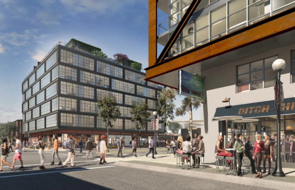
The four mixed-use buildings on Eighth Street near the 9:30 Club are about to open. The quartet is the product of prolific Washington area developer JBG, which recently released the layout of the ground-floor retail tenants. The retail spaces include small retail shops, a few restaurants, a small movie theater, and art galleries.
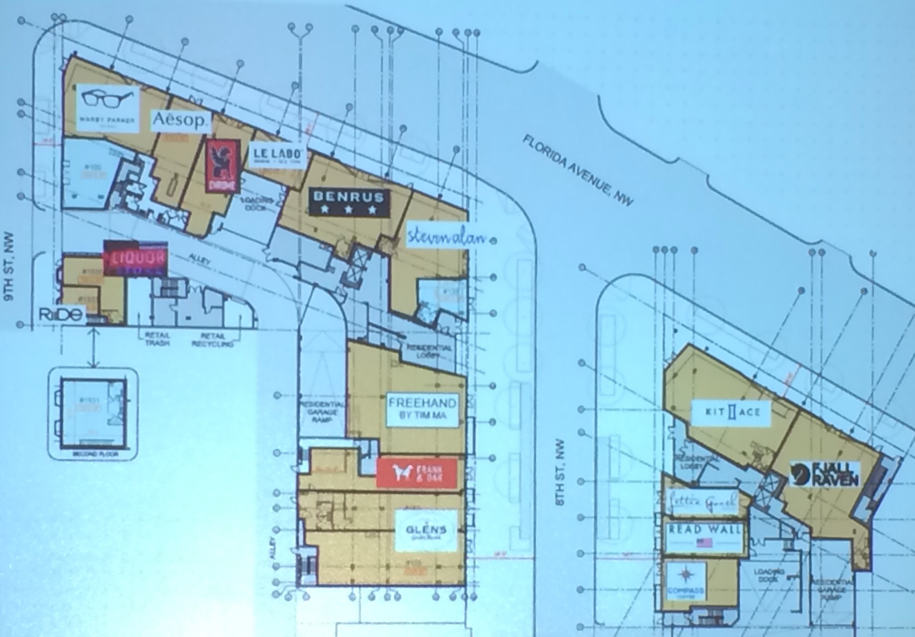
The Shay is a duo of apartments on the 700 and 800 blocks of Florida Avenue NW. Retailers include
- Riide – A DC-based electric bike company (9th Street)
- Serv U Liquors – A liquor store that previous stood on the development site (9th Street)
- Warby Parker – Purveyor of hip spectacles (9th Street & Florida Avenue)
- Aesop – An Australian retailer of sustainable skincare, haircare and other personal care products (800 b/o Florida Avenue)
- Chrome – A San Francisco-based bike bag purveyor (800 b/o Florida Avenue)
- Le Labo – A French perfumery (800 b/o Florida Avenue)
- Benrus – A Rhode Island-based clothing retailer (800 b/o Florida Avenue)
- Steven Alan – Casual clothing for men and women (8th Street & Florida Avenue)
- An unnamed restaurant from Tim Ma, owner of Water & Wall in Arlington and Maple Ave. in Vienna (8th Street)
- Frank & Oak – A hip, Montréal-based men’s clothing retailer (8th Street)
- Glen’s Garden Market – The second location of this DC-based grocer will also serve beer. (8th Street)
- Compass Coffee – The second location for the coffee shop that currently operates on 7th Street in Shaw (8th Street)
- Read Wall – DC-based menswear retailer selling knits, outerwear, custom suits, and neckware (8th Street)
- Lettie Gooch – A clothing boutique moving from U Street (8th Street)
- Kit and Ace – A retailer selling clothes made of a sturdier cashmere (8th Street & Florida Avenue)
JBG is still actively leasing three retail bays. The Shay’s grand opening is today from 6 pm to 9 pm.
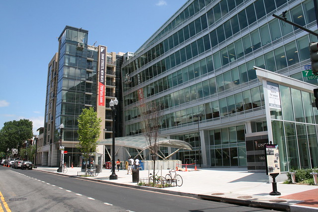
Just north on Eighth Street at V Street, JBG has sold numerous condos at 2030 8th Street and has nearly completed the larger Atlantic Plumbing apartments on the north side of V Street. The company has released the retail layout of both buildings.
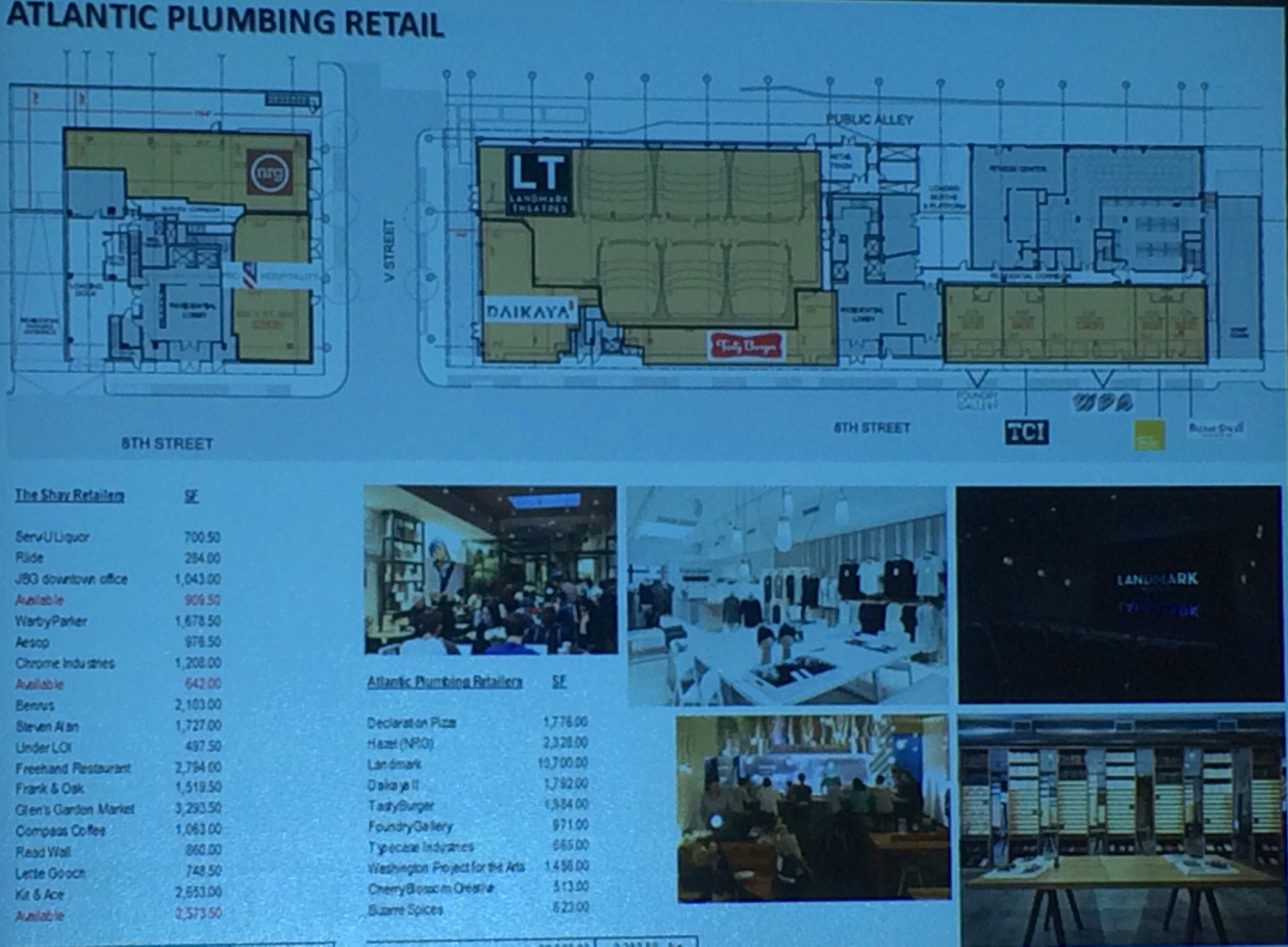
The retailers include
- Hazel (probably) – A new restaurant from Neighborhood Restaurant Group, which currently owns Birch & Barley and Bluejacket (V Street)
- Declaration Pizza – A new pizza shop from the owners of Lincoln and Teddy & the Bully Bar (8th & V Streets)
- Landmark Theatre – A theater featuring independent films in six small-screen mini-theaters (V Street)
- An unnamed ramen restaurant from the people behind Daikaya in Chinatown (8th & V Streets)
- Tasty Burger – The first DC-area location of this Boston-based burger chain (8th Street)
- Bazaar Spices – The second location for this independently owned herbs and spice shop, which also sells at Union Market (8th Street)
- Cherry Blossom Creative – A graphic-design studio that will also offer original works for retail purchase (8th Street)
- Foundry Gallery – An artist-run gallery that will move from Dupont Circle (8th Street)
- Typecase Industries – A locally-based letterpress and design studio (8th Street)
- Washington Project for the Arts – The headquarters for a non-profit arts support organization (8th Street)
All shops will be open by the end of the year.
LeDroit resident meets his former teacher, the pope
Pope Francis is in Washington visiting President Obama, addressing Congress, canonizing Junípero Serra, addressing the public, and leading masses. He’s also reuniting with a former student, Yayo Grassi, a LeDroit Park resident.
Mr. Grassi grew up in Argentina, where Jorge Mario Bergoglio, now Pope Francis, was one of his teachers. Mr. Grassi moved to LeDroit Park in the 1990s and runs a catering company whose food I get to devour at a local Christmas party every year.
Today Mr. Grassi (in the blue jacket), reunited with his former teacher at the Apostolic Nunciature, the Vatican’s Embassy in Washington.
Free history walking tours of LeDroit Park this month


Come on out for a free history walking tour of LeDroit Park. I conduct this tour annually as part of WalkingTown DC.
We will explore the unique architecture and the historical figures who transformed the neighborhood into the home of Washington’s black intelligentsia at the start of the 20th century. Neighborhood notables included Dr. Anna J. Cooper, Mayor Walter Washington, Sen. Edward Brooke, Rep. Oscar De Priest, Paul Laurence Dunbar, Mary Church Terrell, Duke Ellington, and Rev. Jesse Jackson. We will also admire the unique 19th-century houses and the 12 distinct architectural styles present in the neighborhood.
The tours will be on Saturday, September 19 at 1 pm and Sunday, September 27 at 1pm. Meet me at the arch at 6th Street and Florida Avenue NW. The tours are free and open to the public.
Neighborhood happy hour on Sep. 8, block party on Sep. 12
The LeDroit Park Civic Association has organized some social events for everyone to attend.
The next neighborhood happy hour will be on Tuesday, September 8 from 6:30 pm to 8 pm at BKK Cookshop (1700 New Jersey Ave NW). BKK, named for Bangkok’s airport code, is located in the former Beau Thai space, which recently decamped for 7th Street in Shaw.
The Civic Association will also host a neighborhood block party on Saturday, September 12th from noon to 6 pm. The party will be held on the 300 block of U Street. Everyone is welcome to attend and bring additional food.
A lost iPad and thoughtful neighbors
In the wake of Saturday’s homicide on 7th Street, a neighbor posted about her son’s lost iPad on the neighborhood listserv:
Our children and our family friends were witnesses to the shooting yesterday afternoon at 7th and S St. During the chaos, my four year old (who has a developmental disability and can’t speak) dropped his iPad that he uses as a communication device. It is an iPad mini in a life proof case. If you find it, please let us know. There is a reward upon return.
If you found the missing iPad mini, send me a private message and I’ll put you in touch with the family.
Last night the resident posted this thoughtful follow-up:
After we shared a message about the shooting at 7th and S on Saturday and our son’s lost communication iPad, we received so many heartfelt messages of support and concern from friends and neighbors. Thank you for your outreach – it reconfirms everything that we love about living in this community.
We are struggling with how to reconcile this violence in our community with our family’s needs. We are heartbroken for Matthew Shlonsky and his loved ones, we are sad and angry about the violence in our community making it less safe for our kids, and we are committed to fighting the root causes of this violence.
Many people have asked what they can do to help replace our son’s lost communication iPad, and have even offered donations for a new one. We so appreciate all of these offers of support.
We are going to order a new iPad for our son to take to his first day of school next week, but we are also making donations to community organizations that work every day to improve the lives of children and families in our community. We invite you to join us in supporting these organizations, or others of your choosing.
Northwest Settlement House operates a child care center on the corner of 7th and S that serves kids from all backgrounds and helps working parents find affordable childcare.
ONE DC is a community organization, based a block from 7th and S that organizes for access to better jobs and housing.
Crime is up, but murder is rare
On Saturday afternoon, Matthew C. Shlonsky, a recent graduate of American University, was murdered on Seventh Street near the Shaw Metro’s north entrance. Mr. Shlonsky’s murder is part of a documented uptick in violence across Washington.
Crime has risen and MPD’s online data tool reveals this.
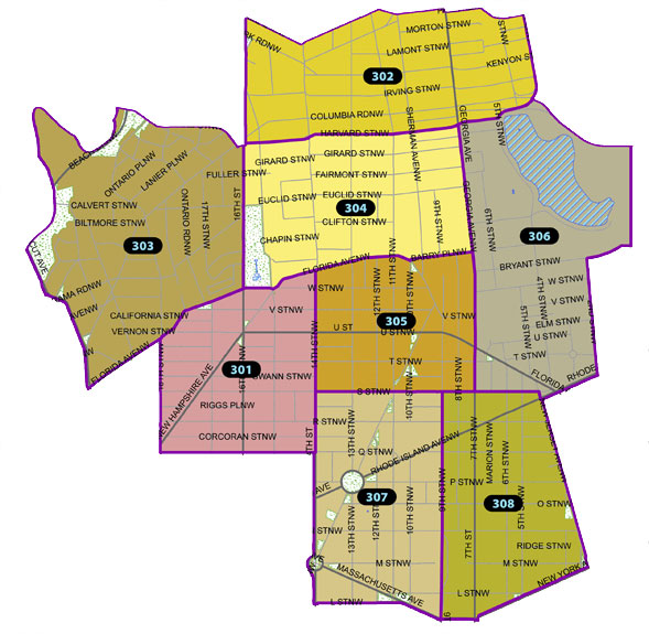
LeDroit Park, Howard University, and the section of Shaw near Progression Place are in police service area (PSA) 306. Over the past 12 months, violent crime has increased 8.1%, property crime has increased 4.9%, and total crime has increased 5.4% compared to the 12 months before that.
| Number of Crimes Reported Between | ||||
| Crime Type | 8/17/2013 to 8/17/2014 | 08/17/2014 to 08/17/2015 | Change | |
| Homicide | 0 | 1 | +1 | |
| Sex Abuse | 4 | 4 | 0 | |
| Robbery Excluding Gun | 19 | 24 | +5 | |
| Robbery With Gun | 17 | 14 | -3 | |
| Assault Dangerous Weapon (ADW) Excluding Gun | 20 | 16 | -4 | |
| Assault Dangerous Weapon (ADW) Gun | 2 | 8 | +6 | |
| Total Violent Crime | 62 | 67 | +5 | |
| Burglary | 21 | 13 | -8 | |
| Theft | 129 | 140 | +11 | |
| Theft F/Auto | 157 | 168 | +11 | |
| Stolen Auto | 20 | 23 | +3 | |
| Arson | 1 | 0 | -1 | |
| Total Property Crime | 328 | 344 | +16 | |
| Total Crime | 390 | 411 | +21 | |
However, when looking at year-to-date numbers for 2015 (Jan. 1 – Aug. 18, 2015) versus the same range last year (Jan. 1 – Aug. 18, 2014), violent crime declined 8.1%, property crime tumbled 10.9%, and total crime in the fell 10.6%.
| Number of Crimes Reported Between | ||||
| Crime Type | 1/1/2014 to 8/18/2014 | 01/01/2015 to 08/18/2015 | Change | |
| Homicide | 0 | 1 | +1 | |
| Sex Abuse | 3 | 0 | -3 | |
| Robbery Excluding Gun | 11 | 12 | +1 | |
| Robbery With Gun | 10 | 6 | -4 | |
| Assault Dangerous Weapon (ADW) Excluding Gun | 11 | 10 | -1 | |
| Assault Dangerous Weapon (ADW) Gun | 2 | 5 | +3 | |
| Total Violent Crime | 37 | 34 | -3 | |
| Burglary | 15 | 9 | -6 | |
| Theft | 87 | 72 | -15 | |
| Theft F/Auto | 84 | 85 | +1 | |
| Stolen Auto | 16 | 14 | -2 | |
| Arson | 0 | 0 | 0 | |
| Total Property Crime | 202 | 180 | -22 | |
| Total Crime | 239 | 214 | -25 | |
Mr. Shlonsky’s murder, though tragic, is rare. In the past five years, the only other person murdered was a man found with stab wounds in car that crashed on Florida Avenue in the early hours of May 1, 2012. He was believed to be driving himself to the hospital.
Residents concerned about crime are encouraged to attend the ANC 1B public safety meeting on Thursday, August 20 at 7 pm at the Thurgood Marshall Center (1816 12th St NW).
[This post has been updated to include year-to-date crime numbers.]
The Royal offers new happy hour specials

The Royal, the new restaurant at Fifth Street and Florida Avenue, is offering two new happy hours. I typically get breakfast at the Royal on weekends since they serve hot breakfast items and an array of coffee drinks. I’m always surprised how many strollers I see in that place; the Royal’s breakfast is popular with the sippy cup set.
For adults the Royal is offering a new happy hour from 3 pm to 6 pm daily and 10 pm to 1 am Sundays through Thursdays:
- $5 house vermouth (the vermouth in the vintage copper fire extinguisher)
- $5 Narragansett tallboys
- $7 classic cocktails
- Daiquiris
- Palomas
- Caipirinhas
- Old Fashioneds
- others
- $7 wine by the glass: one red, one white (daily rotating selection)
Washington Post features an alley dwelling renovation in LeDroit
How do you convert a rundown carriage house into a compact apartment? One LeDroit Park resident did it with $50,000 and some elbow grease. The converted unit, which the owner rents on airbnb, is nestled in the quiet alley that connects Fourth and Fifth Streets just south of T Street.
I’m friends with the owner and he gave me a tour as he was starting the renovation two years ago. It’s great to see such a drastic transformation. Read the full story in the Washington Post.
Buy a McGill house for $1.4 million
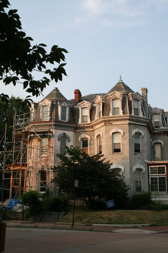
One of the original McGill houses of LeDroit Park is up for sale for $1.4 million. The Second Empire manse on Anna Cooper Circle (1901 Third St, specifically), contains seven bedrooms and 4.5 bathrooms across 3,235 sq. ft. The house is one-half of a duplex and both are pictured in the 2010 photo above (1901 is on the right).
The house’s mansard roof is a signature feature of the Second Empire style along with window moulding, ornate porches, ornate brackets, prominent eaves, and prominent cornices.
In the late 19th century, the house was the home of General William Birney, a southern abolitionist who served in the Union Army during the Civil War. After the war, Birney moved to Washington to establish a law practice. He lived in LeDroit Park for a few years and eventually retired to Montgomery County, Md.
The house previously sold for $133,636 in 1997.
Doug Brown, co-owner of Costa Brava, has died
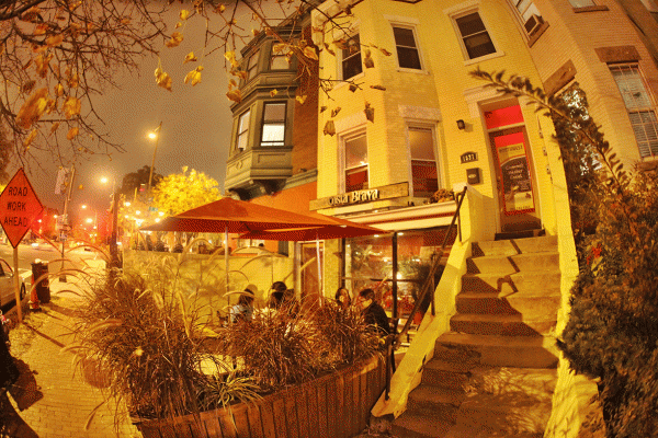
Doug Brown, the co-owner of Bloomingdale’s Costa Brava restaurant, drowned in the Chesapeake Bay on Friday evening.
Mr. Brown had hosted LeDroit Park happy hours at his restaurant and welcomed the LeDroit Park Civic Association’s executive board to meet in the restaurant. Many remember Mr. Brown as the friendly guy managing operations upstairs at Costa Brava. Mr. Brown’s generosity and his friendly and welcoming personality will be sorely missed.
Neighbors will be signing a condolence card on Thursday; please feel free to add your name.


Recent Comments