Eye in the Sky (1988 – 2009)
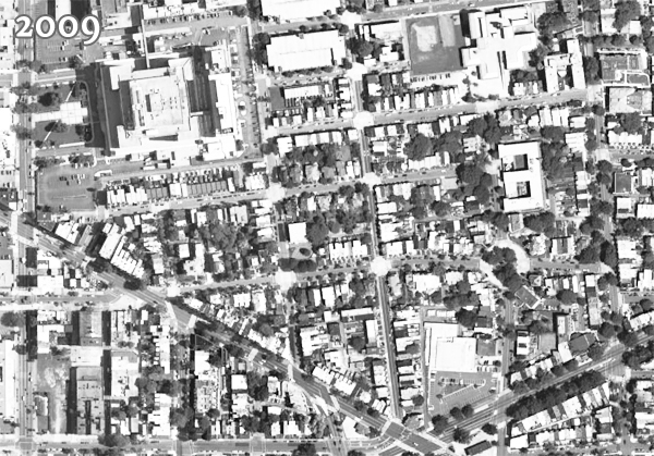
What a difference twenty-one years make. Below are two satellite photos of LeDroit Park— one taken in 1988 and the other taken in 2009. Toggle back and forth between the two to see how the neighborhood’s footprint has changed.

There are a few noticeable changes:
- Howard University Hospital built an annex behind the main hospital building.
- The entire block bounded by Fourth Street, Fifth Street, V Street, and Oakdale Place is now a multi-level parking garage.
- In 1988, the 500 block of U Street looked gap-toothed; new houses have since been built to fill out the entire north side of the street.
- Street intersections have been replaced with concrete while the roadways remain asphalt.
- The tree canopy is much more expansive now (or the 1988 photo was taken in the winter).
- Houses have been built on the once-vacant land around the northeast corner of Fourth and U Streets.
- The intersection of T Street, Sixth Street, and Florida Avenue has been reconfigured, making way for the pocket park home to the LeDroit Park entrance arch.
- The Schoolhouse Lofts condo building has since been built at Second and V Streets.
Did we miss anything?


It appears the 2009 photo was taken early in 2009, if not earlier than that. One big change in the neighborhood since the 2009 photo was taken is the demolition of the old Gage-Eckington School and the founding of Common Good City Farm on what used to be the school’s baseball diamond. Hopefully, by late 2010, an overhead photo of the area will reveal a beautiful 2-acre park, which includes the already up-and-running half-acre Farm.