
Get a rare glimpse of the McMillan Sand Filtration Site
This weekend we got a rare tour of the dormant McMillan Sand Filtration Site just north of Bloomingdale.
The site sits behind locked fences between North Capitol Street, Channing Street NW, 1st Street NW, and Michigan Avenue NW. The filtration site opened in 1905 to purify river water supplied to a burgeoning capital.
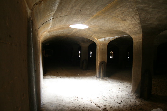
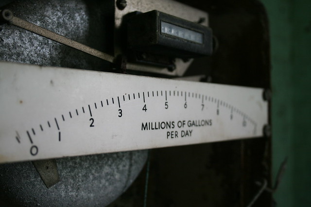
The filtration plant contains 25 acres of underground sand filtration cells. Water flows from the “castle” on McArthur Boulevard NW at the Georgetown Reservoir through an arrow-straight tunnel to the valve house on 4th Street at the McMillan Reservoir.

Diagram of the Washington City Tunnel, U.S. Army Corps of Engineers
The reservoir opened in 1902 and is actually a dammed stream valley. Since the reservoir stores untreated river water, the water must be cleaned before it can be distributed to residents’ taps.
At the turn of the 20th century, a debate ensued between proponents of chemical purification and slow sand filtration. Slow sand filtration won the debate and Congress provided money to build the sand filtration cells.

McMillan Sand Filtration Site under construction. Source: U.S. Army Corps of Engineers
The process of slow sand filtration is pretty simple. Water fills a cell that contains 2 feet of sand at the bottom— it’s like an underground beach.
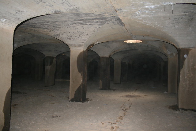
The water percolates through the sand leaving contaminants behind in the sand. When the water reaches the floor under the sand, it exits the cell and is distributed into the city’s water pipes.
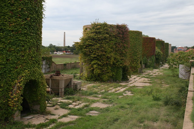
The sand itself required routine cleaning to remove the contiminants. Clean sand was stored in the concrete silos that stand in rows on the site.
Workers replenished the cells by dumping clean sand through the various access holes on the roof of each cell.
In fact, an early photo shows fresh sand dumped into a cell.

Source: U.S. Army Corps of Engineers
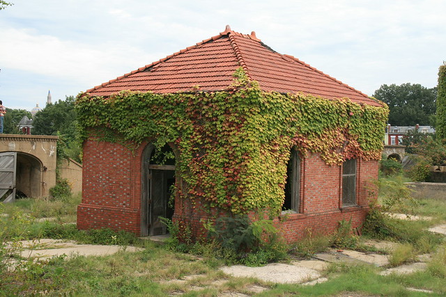
Regulator houses contained valves for regulating the flow of water through each cell.
The top of the filtration site was turned into a park, as envisioned by Sen. James McMillan (R – Michigan), famous for his ambitious McMillan Plan to beautify Washington.
 Frederick Law Olmsted, Jr., designed the park grounds on top of the sand filtration cells. Since the park closed to public access during World War II, the park’s recreational features, including green lawns, park lamps, walkways, and staircases, sit decaying today.
In the 1980s, the U.S. Army Corps of Engineers build a rapid sand filter on the part of the reservoir west of 1st Street NW, thus obviating the need for the slow sand filters east of 1st Street. The western section today holds the active open-air reservoir and rapid sand filters that supply clean water to much of Washington.
That section, which is still an active reservoir and water treatment plant, is closed to the public. What’s most unfortunate is that the western section contains the most notable feature of the reservoir park.
Shortly after Sen. McMillan’s death, Congress and donors in his home state of Michigan decided to honor the senator with an ornate fountain to adorn the park that bears his name.

Source: U.S. Army Corps of Engineers
The 1912 fountain, designed by Herbert Adams, contains a bronze sculpture of 3 nymphs on a pink granite base. In 1941 the fountain was dismantled, left in storage and mostly neglected until the top portion of the fountain was returned to Crispus Attucks Park in 1983. In 1992 the top section was moved to its current location, at the active reservoir site, locked away from public access.
One can still see the top portion of the fountain by glancing through the fence on 1st Street NW.

The base of the fountain remains somewhere in Fort Washington National Park in Prince George’s County. Perhaps someday the District, the federal government, and neighbors can raise the funds to reunite and restore the fountain for public enjoyment.
“LE DROIT PARK. What Three Years Have Done.”
We came across this 1876 article documenting the initial improvements to the nascent LeDroit Park.
LE DROIT PARK. What Three Years Have Done.
National Republican
September 4, 1876Mr. James H. McGill, architect, has forwarded to the inspector of buildings, Mr. Thos. M. Plowman, a communication, in which he furnishes interesting information in relation to the improvements made in LeDroit Park within the last two years. He states that the different tracts of land composing the park were purchased at different times from June, 1872, to March, 1873, by Messrs. A.L. Barber & Co., and united by these gentlemen into one tract, which has been carefully surveyed and recorded. This park is in the form of an equilateral triangle, with one side resting on Boundary street [now Florida Avenue] and reaching from Seventh street eastward to Second street, and contains fifty acres. Until its subdivision by the present proprietor the eastern tract had been used for private residences and grounds, and the western portion had laid uninclosed for several years, and had been used as a public common. Improvements were soon commenced on a liberal scale; a handsome pattern of combination wood and iron fence was adopted and built all along the entire front and a board fence all along the rear, making one inclosure. All the interior fences were removed, and the lots thrown in together, affording a continuous sward. Streets were graded, graveled and guttered, brick sidewalks were put down, and gas, water and sewer mains laid.
The erection of buildings was commenced in July, 1873, since which time eight large brick residences have been erected on the north side of Maple avenue [now T Street] and two on the south side, costing from $4,000 to $12,000 each; ten houses on the north side and ten on the south side of Spruce street [now U Street], at an average cost of $3,500; two houses on the north side of Elm street, costing $3,000 each; four houses on east side, and five on the west side of Harewood avenue [now 3rd Street],costing from $4,000 to $10,000 each. A very superior stable and carriage-house has been completed for A. Langdon, esq., and another is in course of erection for A. R. Appleton, esq. Up to this date forty-one superior residences and two handsome stables have been constructed, at a cost of about $200,000. These houses are either built separately or in couples; are nearly all of brick; of varied designs, no two being alike either in size, shape or style of finish, or in the color of exterior. About $4,000 has been expended in the purchase and planting of ornamental shade trees and hedges, and about $50,000 in street improvements. About 4,500 lineal feet of streets have been graded and graveled, 9,000 feet of stone and brick gutters laid, 5,000 feet of brick pavement, 4,000 feet of sewer mains, 3,550 feet of water mains and 3,800 feet of gas mains laid. All of this expense has been by the proprietors of the property without a dollar from the District or authorities, and all the work has been done in the best and most liberal manner, under the direction of Mr. McGill. The plan contemplates the finishing of all its streets and the erection of two hundred tastefully-designed, conveniently-arranged and well-built detached and semi-detached residences, and when completed cannot fail of being a credit to all concerned. During the time stated the value of improvements constructed in other portions of the county amount to upwards of $100,000.
Heritage Trail meeting tonight
 The fourth meeting of the LeDroit Park-Bloomingdale Heritage Trail working group is this evening. Attend if you’re interested in the history of our neighborhoods and would like to help bring the heritage trail to fruition.
The meeting tonight is at 7 pm at St. George’s Episcopal Church at 2nd and U Streets NW.
In the coming months, Cultural Tourism DC, which sponsors the heritage trails, will collect all the interview transcripts and photographs and draft a series of trail markers like the one pictured right.
After neighborhood review, Cultural Tourism DC will install these markers throughout the neighborhoods marking locations of notable events, buildings, and residents.
Read the flyer for tonight’s meeting.
A Dunbar poem that LeDroit Park inspired
One of LeDroit Park’s notable residents was famed poet Paul Laurence Dunbar. Mr. Dubar lived at 1934 4th St NW with his wife Alice.
After Mr. Dunbar’s death, his widow, Alice, published an article analyzing his poetry. In it she noted that Spruce Street (now LeDroit Park’s segment of U Street NW) inspired the poem “Lover’s Lane”:
The white arc light of the corner lamp, filtering through the arches of the maples on Spruce street, make for the tender suggestion in “Lover’s Lane,” where the lovers walk side by side under the “shadder-mekin’ ”
Below we have reprinted “Lover’s Lane” followed by an old audio recording of Paul Robeson singing a hearty bass-barritone version of the Dunbar poem.
Lover’s Lane
SUMMAH night an’ sighin’ breeze,
’Long de lovah’s lane;
Frien’ly, shadder-mekin’ trees,
’Long de lovah’s lane.
White folks’ wo’k all done up gran’—
Me an’ ’Mandy han’-in-han’
Struttin’ lak we owned de lan’,
’Long de lovah’s lane.Owl a-settin’ ’side de road,
’Long de lovah’s lane,
Lookin’ at us lak he knowed
Dis uz lovah’s lane.
Go on, hoot yo’ Mou’nful tune,
You ain’ nevah loved in June,
An’ come hidin’ f’om de moon
Down in lovah’s lane.Bush it ben’ an’ nod an’ sway,
Down in lovah’s lane,
Try’n’ to hyeah me whut I say
’Long de lovah’s lane.
But I whispahs low lak dis,
An’ my ’Mandy smile huh bliss—
Mistah Bush he shek his fis’,
Down in lovah’s lane.Whut I keer ef day is long,
Down in lovah’s lane.
I kin allus sing a song
’Long de lovah’s lane.
An’ de wo’ds I hyeah an’ say
Meks up fu’ de weary day
Wen I’s strollin’ by de way,
Down in lovah’s lane.An’ dis t’ought will allus rise
Down in lovah’s lane;
Wondah whethah in de skies
Dey’s a lovah’s lane.
Ef dey ain’t, I tell you true,
’Ligion do look mighty blue,
’Cause I do’ know whut I’d do
’Dout a lovah’s lane.
“Worthy Ambition”
Keep your feet firm in the path to the goal.
Toward noble deeds every effort be straining.
Worthy ambition is food for the soul!”
The LeDroit Park-Bloomingdale Heritage Trail Working Group is devising a tagline for our trail. The trail, as we reported, is currently in the planning stages and should be completed in the coming months.
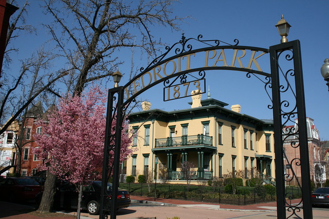
LeDroit Park was established in 1873 as an exclusive suburb of Washington City. When the demographics changed from exclusively white to majority black a century ago, the neighborhood gained the reputation as the home of Washington’s black intelligentsia.
The word ‘intelligentsia’ is a tad too elitist for a tagline, so we need other suggestions that politely, yet honestly, honor the neighborhood’s history.
One resident suggested a tagline we really like: “Worthy ambition”.
The phrase is aptly pulled from “Emancipation“, an 1890 poem by Paul Laurence Dunbar, who resided for several years in LeDroit Park.
Fling out your banners, your honors be bringing,
Raise to the ether your paeans of praise.
Strike every chord and let music be ringing!
Celebrate freely this day of all days.Few are the years since that notable blessing,
Raised you from slaves to the powers of men.
Each year has seen you my brothers progressing,
Never to sink to that level again.Perched on your shoulders sits Liberty smiling,
Perched where the eyes of the nations can see.
Keep from her pinions all contact defiling;
Show by your deeds what you’re destined to be.Press boldly forward nor waver, nor falter.
Blood has been freely poured out in your cause,
Lives sacrificed upon Liberty’s altar.
Press to the front, it were craven to pause.Look to the heights that are worth your attaining
Keep your feet firm in the path to the goal.
Toward noble deeds every effort be straining.
Worthy ambition is food for the soul!Up! Men and brothers, be noble, be earnest!
Ripe is the time and success is assured;
Know that your fate was the hardest and sternest
When through those lash-ringing days you endured.Never again shall the manacles gall you
Never again shall the whip stroke defame!
Nobles and Freemen, your destinies call you
Onward to honor, to glory and fame.
It’s a fine work and an excellent way to capture the neighborhood’s ambitious history.
Help write history this Saturday
The third meeting of the LeDroit Park-Bloomingdale Heritage Trail working group is Saturday. Attend if you’re interested in the history of our neighborhoods and would like to help bring the heritage trail to fruition.
The next meeting is Saturday, April 16 at 10 am at the office of the Howard University Community Association, 2731 Georgia Avenue.
In the coming months, Cultural Tourism DC, which sponsors the heritage trails, will collect all the interview transcripts and photographs and draft a series of trail markers like the one pictured right.
After neighborhood review, Cultural Tourism DC will install these markers throughout the neighborhoods marking locations of notable events, buildings, and residents.
Read the flyer for Saturday’s meeting.
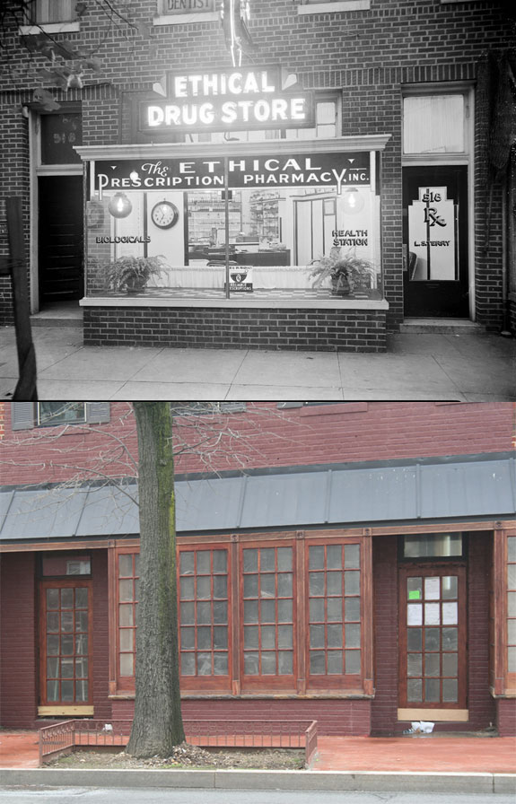
Before Shaw’s Tavern there was Ethical Pharmacy
This is the fourth in a series of the Scurlock photos. Read the others.
We have reported before on the coming of Shaw’s Tavern to the building (pictured above) at the southeast corner of 6th Street and Florida Avenue. It turns out that the bar at Shaw’s Tavern will not the be the first establishment to stir up elixirs at that location.
While perusing the Smithsonian’s Scurlock photo archives, we found that one of the building’s previous tenants was the Ethical Drug Store (also known as Ethical Prescription Pharmacy and Ethical Pharmacy), one of the many black-owned businesses along the 400 – 600 blocks of Florida Avenue NW.
Pharmacist Lewis Terry (1904- 1978) graduated from pharmacy school at Temple University in 1928. The following year he opened Ethical Pharmacy at 518 Florida Avenue NW. The pharmacy had filled 1 million prescriptions by 1953 earning him a special honor from Temple. Though Mr. Terry sold the business in the mid-60s, the pharmacy stayed in operation until the 1990s.
The name Ethical Pharmacy is a relic of a professional division in the pharmacy field a century ago. An “ethical pharmacy” proudly devoted itself solely to filling prescriptions and did not sell other extraneous products as modern drug stores, such as CVS, do today. The use of ‘ethical’ was a high-minded misnomer since a pharmacist could sell other wares ethically or devote himself exclusively to quack medicine.
The Scurlock Studio photographed the pharmacy in 1937 and again in 1950. We have included both photo shoots below.
1937
Here is a photo Addison Scurlock took of Ethical Pharmacy in 1937:
[Toggling between now and then photos will not work in RSS readers. View the actual post]
Here are some other shots of the interior. Though the Smithsonian has no date for the first two, we suspect they was shot in the 1930s. The third photo is dated 1937 and judging from the change in the interior, we suspect the pharmacy had undergone some sort of renovation to appear more modern.


1950
Mr. Scurlock photographed the pharmacy again in July 1950:

[Toggling between now and then photos will not work in RSS readers. View the actual post]
He also took more shots of the interior in 1950:


1968 riots at 7th & T Streets NW
This is the third in a series on the Scurlock photo archive. Read the others.
The 1968 riots burned and economically destroyed many commercial districts throughout Washington. Riots came to U Street, too, and several properties which were obliterated have not entirely recovered from the devastation.
After World War II, many of America’s cities faced population and economic decline as the nation suburbanized; Washington was certainly no exception. The retail corridors on 14th St NW, U St NW, and H St NE were already declining when riots hit American cities in 1968 following the Martin Luther King’s assassination.
Addison Scurlock (1883-1964) was Washington’s most prominent black photographer and when the riots started in April 1968, Mr. Scurlock[‘s sons, who inherited his studio] at 9th and U Streets (where Nellie’s now stands) knew that [they were]he was witnessing history in the making. Mr. Scurlock The Scurlocks photographed rioters at the beginning of the riots and photographed some of the aftermath.
The corner of 7th Street, Florida Avenue, and Georgia Avenue suffered from the mayhem. The southwest corner now houses a CVS and a parking lot on land that Howard University owns. Beneath this store runs the Metro tunnel between the Shaw and U Street stations. Back in 1968, this site featured a strip of retail stores until the riot.
One of the most striking Scurlock photos is of the northwest corner of 7th and T Streets NW, where the CVS currently stands. Rioters burned the buildings that stood on the site.
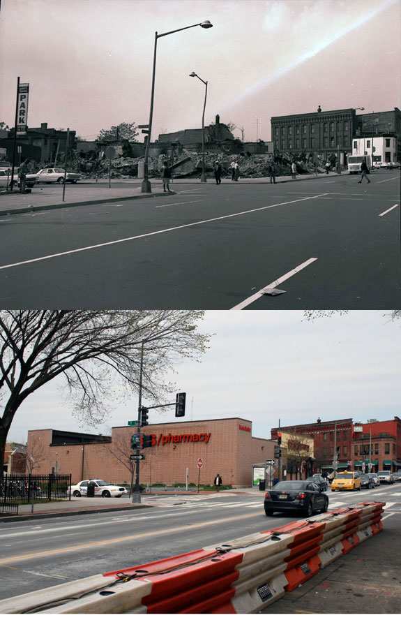
[Toggling between now and then photos will not work in RSS readers. View the actual post]
7th & T was always the seedier end of the U Street corridor
This is the second in a series on the Scurlock photo archive. Read the first entry.
During the Jazz Age of the 1920s and later into the 1930s, U Street was dubbed the “black Broadway” as it featured such venues as the Lincoln Colonnade (now the Lincoln Theater), the Howard Theatre, and other clubs and restaurants. In a segregated city in which blacks were excluded from most restaurants, theaters, and stores, U Street served as a refuge to catch a show and enjoy a meal.
This photo from the Scurlock archives was taken looking east at 7th and T Streets NW in 1939.
[Toggling between now and then photos will not work in RSS readers. View the actual post]
We have referred to this area as the block of blight for its dilapidated buildings, copious litter, and frequent police arrests. It turns out that some things never change. Even when this photograph was taken, U Street was not uniform in character and the area around the Howard Theatre was considered downscale compared to the classier venues west on U Street. (For more on U Street’s evolution, see Blair Ruble’s recent book, Washington’s U Street: A Biography.)
Pictured here at the corner is National Grill, which, like Harrison’s Café in LeDroit Park, advertised itself as open all night. The lighted vertical sign attached to the façade appears to read “LUNCH” and the pediment at the cornice bears the building’s name, “Scott’s”. (View a larger version of the photo.)
Just to the right (south) of National Grill is the S.W. Keys Luncheonette, whose vertical sign advertises coffee and waffles. Just south of that is Harlem Cafe, located in a building that has since been replaced.
On T Street, just behind Scott’s Building and just before the Howard Theatre, you will see a sign that reads “BILLIARDS”. That marks Frank Holliday’s pool hall, a popular gathering spot for Howard scholars, jazz musicians, and city laborers alike. Duke Ellington captured the scene at the pool hall:
Guys from all walks of life seemed to converge there: school kids over and under sixteen; college students and graduates, some starting out in law and medicine and science; and lots of Pullman porters and dining-car waiters.
Just beyond the pool hall, you’ll see the Howard Theatre sporting its original Italianate façade. The theater was later covered with plaster, which was only recently removed for the restoration project.
Today the last two buildings on 7th Street are a Chinese take-out and a tiny market. One of the developers of Progression Place, the large development project underway on the block (rendering below), said that the late owner of these two buildings refused to sell to his development. Progression Place will incorporate every building on this block except for these two.
If anyone is looking for a two-building restoration project, here is your chance!

Progression Place will include all but the gray and orange buildings.
Scurlock archives: Harrison’s Café
If you have ever walked by Nellie’s Sports Bar at 9th and U Streets NW, you may have noticed a small plaque on the wall noting the site of the former Scurlock Studio.
Addison Scurlock (1883-1964) was a prolific Washington photographer whose studio stood at that corner from 1911 to 1976. During his lifetime, Mr. Scurlock’s studio photographed mundane portraits and scenes, but also photographed famous people such as Frederick Douglass, Marian Anderson at the Lincoln Memorial and Martin Luther King and FDR at Howard University.
The Smithsonian purchased his collection and in paging through the online catalog, we found several photographs of scenes around LeDroit Park. This is the first in a series of photos.
[Toggling between now and then photos will not work in RSS readers. View the actual post]
This undated photograph shows Harrison’s Café, which stood at 455 Florida Avenue NW on the edge of LeDroit Park. It was a neighborhood restaurant and bar that attracted the various musical and academic notables of the area.
HARRISON’S CAFÉ
OPEN ALL NITE
SALADS SANDWICHES
Update: We took a trip to the Washingtoniana Division of the MLK Library and found more information on Harrison’s Café.
Robert Hilliard Harrison opened a candy store at 467 Florida Avenue NW and soon opened his cafe at 455 Florida Avenue NW in 1920. Harrison’s Café catered to a variety of appetites, serving fancy lobsters to 20-cent hamburgers. In an era of segregated restaurants, black residents have fewer dining choices and Harrison’s tried to serve them all.
Attached to the cafe, Mr. Harrison also owned the Golden Room, which hosted banquets and private events. Above the cafe, Harrison’s served liquor privately after the city’s midnight liquor curfew.
After World War II, LeDroit Park, like other close-in urban neighborhoods suffered from disinvestment and decline. Mr. Harrison died in 1957 and the restaurant closed in 1962.
Further reading:
- Fitzpatrick, Sandra. The Guide to Black Washington.
- Ruble, Blair A. Washington’s U Street: A Biography.


Recent Comments