
Street names changed in 1890

Two years ago we wrote about the old street names for LeDroit Park. Finding out just when the name change occurred is hard to pin down. Different sources, from address directories to newspaper articles, refer to old names and new names during the same period of time.
The mystery is closer to resolution, however, as we found what we believe to be the earliest reference to the name change:
New Names for Le Droit Park Streets.
Washington Post
July 31, 1890The names of the streets in Le Droit Park have been changed as follows: Le Droit Park avenue to Second street, Harewood avenue to Third street, Linden street to Fourth street, Larch street to Fifth street, Juniper street to Sixth street, and Maple avenue to T street.
There appears to be an error in the article as ‘Le Droit avenue’ never actually had ‘Park’ in its name.
What Anna Cooper Circle looked like 100 years ago

This photo, taken around 1910, shows the fire brigade on T Street just west of Anna J. Cooper Circle. The circle’s landscaping was much sparser then than it is today, but you will also notice that this was taken before the city altered 3rd Street to bisect the circle for several decades.
One will also notice the now-razed McGill house on the right side of the photo. That lot now hosts the rectangular brick apartment building that clearly never faced historic preservation review.
We haven’t been able to find any news stories explaining what exactly happened the day of the photo.
“LE DROIT PARK. What Three Years Have Done.”
We came across this 1876 article documenting the initial improvements to the nascent LeDroit Park.
LE DROIT PARK. What Three Years Have Done.
National Republican
September 4, 1876Mr. James H. McGill, architect, has forwarded to the inspector of buildings, Mr. Thos. M. Plowman, a communication, in which he furnishes interesting information in relation to the improvements made in LeDroit Park within the last two years. He states that the different tracts of land composing the park were purchased at different times from June, 1872, to March, 1873, by Messrs. A.L. Barber & Co., and united by these gentlemen into one tract, which has been carefully surveyed and recorded. This park is in the form of an equilateral triangle, with one side resting on Boundary street [now Florida Avenue] and reaching from Seventh street eastward to Second street, and contains fifty acres. Until its subdivision by the present proprietor the eastern tract had been used for private residences and grounds, and the western portion had laid uninclosed for several years, and had been used as a public common. Improvements were soon commenced on a liberal scale; a handsome pattern of combination wood and iron fence was adopted and built all along the entire front and a board fence all along the rear, making one inclosure. All the interior fences were removed, and the lots thrown in together, affording a continuous sward. Streets were graded, graveled and guttered, brick sidewalks were put down, and gas, water and sewer mains laid.
The erection of buildings was commenced in July, 1873, since which time eight large brick residences have been erected on the north side of Maple avenue [now T Street] and two on the south side, costing from $4,000 to $12,000 each; ten houses on the north side and ten on the south side of Spruce street [now U Street], at an average cost of $3,500; two houses on the north side of Elm street, costing $3,000 each; four houses on east side, and five on the west side of Harewood avenue [now 3rd Street],costing from $4,000 to $10,000 each. A very superior stable and carriage-house has been completed for A. Langdon, esq., and another is in course of erection for A. R. Appleton, esq. Up to this date forty-one superior residences and two handsome stables have been constructed, at a cost of about $200,000. These houses are either built separately or in couples; are nearly all of brick; of varied designs, no two being alike either in size, shape or style of finish, or in the color of exterior. About $4,000 has been expended in the purchase and planting of ornamental shade trees and hedges, and about $50,000 in street improvements. About 4,500 lineal feet of streets have been graded and graveled, 9,000 feet of stone and brick gutters laid, 5,000 feet of brick pavement, 4,000 feet of sewer mains, 3,550 feet of water mains and 3,800 feet of gas mains laid. All of this expense has been by the proprietors of the property without a dollar from the District or authorities, and all the work has been done in the best and most liberal manner, under the direction of Mr. McGill. The plan contemplates the finishing of all its streets and the erection of two hundred tastefully-designed, conveniently-arranged and well-built detached and semi-detached residences, and when completed cannot fail of being a credit to all concerned. During the time stated the value of improvements constructed in other portions of the county amount to upwards of $100,000.
Census data for LeDroit Park
In preparation for redistricting Ward 1’s ANCs, the DC Office of Planning has released block-by-block demographic data for the District. We have combined the data for the blocks that comprise LeDroit Park to create a LeDroit Park census.
Analyzing U.S. Census data for LeDroit Park proves difficult because the of the way census tracts are drawn. Our census tract, 34, combines LeDroit Park and Howard University. Dorms on the northern end of the campus, far away from LeDroit Park, account for 717 of the tract’s 4,347 residents, thus skewing tract data. Furthermore, the tract also inclues several blocks bounded by Rhode Island Avenue NW, Florida Avenue NW, and 2nd Street NW.
Fortunately, the Census Bureau provides data for each block, allowing us to combine the statistics for those blocks in LeDroit Park, while excluding the Howard University campus. In the map below, we have outlined the tract in blue and shaded the blocks for LeDroit Park in red.
View LeDroit Park Census in a larger map
Though LeDroit Park started out as an exclusively white suburban neighborhood, by 1910 the neighborhood was almost entirely black. Today, 100 years later, the neighborhood is 70% black and is continuing to diversify.

However, when looking at the numbers on a block-by-block basis, you see that the neighborhood demography, must like that of the District itself, is unevenly distributed.
The block bounded by 5th Street, T Street, 6th Street, and U Street is 53% white, the highest in the neighborhood. Likewise, the block containing the Kelly Miller public housing is 91% black, the highest percentage in the neighborhood. The block containing the arch and the Florida Avenue Baptist Church comes closest to black-white equilibrium at 44% and 49% for each group respectively.

When looking at total population numbers for each block, you see that the two most populous blocks contain Howard University dorms. The block bounded by 2nd Street, T Street, 3rd Street, and Elm Street has 382 residents and contains Slowe Hall, which houses 299 students.
The second most populous block contains the new park. However, it also contains Carver Hall, which itself houses 173 students. Certainly these blocks are big, but the fact that their population numbers are off the chart has more to do with student dorms than with any inherent difference in housing density.

Finally, when we look at housing vacancy, we see that the block bounded by 5th Street, T Street, 6th Street and U Street has 38% of its housing units vacant. We’re not sure what’s causing this number, but we suspect that the apartment building at 5th and U Streets NW boosted the vacancy rate. The building has since been finished and is fully rented.
The block with the second-highest rate of vacancy contains the now-renovated Ledroit Place condo building at 1907 3rd Street NW.

It would be interesting too look at other data, including household income, car ownership, and age distribution for the neighborhood. However, the Office of Planning’s spreadsheet only covered population numbers, racial distribution, and housing unit numbers, so those are the metrics we graphed.
1968 riots at 7th & T Streets NW
This is the third in a series on the Scurlock photo archive. Read the others.
The 1968 riots burned and economically destroyed many commercial districts throughout Washington. Riots came to U Street, too, and several properties which were obliterated have not entirely recovered from the devastation.
After World War II, many of America’s cities faced population and economic decline as the nation suburbanized; Washington was certainly no exception. The retail corridors on 14th St NW, U St NW, and H St NE were already declining when riots hit American cities in 1968 following the Martin Luther King’s assassination.
Addison Scurlock (1883-1964) was Washington’s most prominent black photographer and when the riots started in April 1968, Mr. Scurlock[‘s sons, who inherited his studio] at 9th and U Streets (where Nellie’s now stands) knew that [they were]he was witnessing history in the making. Mr. Scurlock The Scurlocks photographed rioters at the beginning of the riots and photographed some of the aftermath.
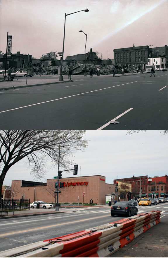
The corner of 7th Street, Florida Avenue, and Georgia Avenue suffered from the mayhem. The southwest corner now houses a CVS and a parking lot on land that Howard University owns. Beneath this store runs the Metro tunnel between the Shaw and U Street stations. Back in 1968, this site featured a strip of retail stores until the riot.
One of the most striking Scurlock photos is of the northwest corner of 7th and T Streets NW, where the CVS currently stands. Rioters burned the buildings that stood on the site.
[Toggling between now and then photos will not work in RSS readers. View the actual post]
7th & T was always the seedier end of the U Street corridor
This is the second in a series on the Scurlock photo archive. Read the first entry.
During the Jazz Age of the 1920s and later into the 1930s, U Street was dubbed the “black Broadway” as it featured such venues as the Lincoln Colonnade (now the Lincoln Theater), the Howard Theatre, and other clubs and restaurants. In a segregated city in which blacks were excluded from most restaurants, theaters, and stores, U Street served as a refuge to catch a show and enjoy a meal.
This photo from the Scurlock archives was taken looking east at 7th and T Streets NW in 1939.
[Toggling between now and then photos will not work in RSS readers. View the actual post]
We have referred to this area as the block of blight for its dilapidated buildings, copious litter, and frequent police arrests. It turns out that some things never change. Even when this photograph was taken, U Street was not uniform in character and the area around the Howard Theatre was considered downscale compared to the classier venues west on U Street. (For more on U Street’s evolution, see Blair Ruble’s recent book, Washington’s U Street: A Biography.)
Pictured here at the corner is National Grill, which, like Harrison’s Café in LeDroit Park, advertised itself as open all night. The lighted vertical sign attached to the façade appears to read “LUNCH” and the pediment at the cornice bears the building’s name, “Scott’s”. (View a larger version of the photo.)
Just to the right (south) of National Grill is the S.W. Keys Luncheonette, whose vertical sign advertises coffee and waffles. Just south of that is Harlem Cafe, located in a building that has since been replaced.
On T Street, just behind Scott’s Building and just before the Howard Theatre, you will see a sign that reads “BILLIARDS”. That marks Frank Holliday’s pool hall, a popular gathering spot for Howard scholars, jazz musicians, and city laborers alike. Duke Ellington captured the scene at the pool hall:
Guys from all walks of life seemed to converge there: school kids over and under sixteen; college students and graduates, some starting out in law and medicine and science; and lots of Pullman porters and dining-car waiters.
Just beyond the pool hall, you’ll see the Howard Theatre sporting its original Italianate façade. The theater was later covered with plaster, which was only recently removed for the restoration project.
Today the last two buildings on 7th Street are a Chinese take-out and a tiny market. One of the developers of Progression Place, the large development project underway on the block (rendering below), said that the late owner of these two buildings refused to sell to his development. Progression Place will incorporate every building on this block except for these two.
If anyone is looking for a two-building restoration project, here is your chance!

Progression Place will include all but the gray and orange buildings.
New Condos Coming to Shaw and 14th Street

Florida Avenue elevation for Douglas Development's proposal for 2221 Fourteenth Street NW
The monthly meeting of ANC1B will be on Thursday, December 2 at 7pm in the Reeves Building at Fourteenth and U Streets NW. Here are some of the highlights from the agenda:
Development/Public Space
The commission will likely support the zoning relief application for 2221 14th Street NW (image above). In a rare residential foray, Douglas Development seeks to build a condo building at the southeast corner of Fourteenth Street and Florida Avenue. The company is seeking support for several variances and special exceptions, mostly regarding the roof structure, rear setback, and parking requirements. View the designs and zoning application.
 The commission is also likely to lend its support to the Arts District Branding Project, which is developing graphic banners (sample at right) to hang from lights posts along Fourteenth Street and U Street. The banner is part of a $200,000 city-funded branding project to enhance the marketing and identity of the arts district that stretches along Fourteenth Street from Rhode Island Avenue to Florida Avenue and along U Street from Seventeenth Street to Seventh Street.
DDOT prefers that private groups obtain ANC support before the agency permits groups to hang banners on poles for 90 – 180 days. After the 180-day term, the banners remain up until another group wishes to use the poles or until the group removes them.
Also on the agenda is the District-owned Parcel 39 at the southwest corner of Eighth and T Streets in Shaw. The site is currently a parking lot, but Mayor Fenty, in the waning days of his mayoralty, is seeking to sell the lot to a development team with plans to construct a four-unit condo building. The sale price, or proposed sales price, has not yet been disclosed.
Alcohol Licenses
Two licensees are looking to modify their licenses:
Alero Restaurant & Lounge (1301 U Street) looks to amend its Class C license to include a 44-seat sidewalk café serving alcohol from 11:30 am to 1 am Sunday through Saturday.
Nearby, the Islander Caribbean Restaurant & Lounge (1201 U Street) wants to extend its hours and expand to the second floor. Currently their hours are Sunday 10 am- 2 am and Thursday-Saturday 10 am-2 am. They propose these new hours: Sunday through Saturday, 6 am-4 am with alcohol served Sunday 10 am-2 am, Monday-Thursday 8 am-2 am, and Friday – Saturday 8 am-3 am.
The commission will likely renew the following licenses as a formality:
- Duffy’s Irish Restaurant (2106 Vermont Avenue)
- Hominy/Bohemian Caverns (2001 11th Street)
- Dickson Wine (903 U Street)
- Velvet Lounge (915 U Street)
- Indulj (1208 U Street)
- Desperados Pizza (1342 U Street)
- Patty Boom Boom (1359 U Street)
- Marvin (2007 14th Street)
- The Gibson (2009 14th Street)
- Café Collage (1346 T Street)
- Jin (2017 14th Street)
Sharing in LeDroit Park
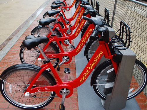
Construction is still moving along at the park on the site of the former Gage-Eckington School. In addition to the dog park, playground equipment, picnic tables, and field, there are two more amenities on their way to the site: bike sharing and car sharing. DDOT’s assistance in integrating both car sharing spaces and its own Capital Bikeshare (CaBi) system is a good example of collaboration between different city agencies.
ZipCar is a subscription service that places cars throughout several cities worldwide and rents the cars to members by the hour. The rental fee includes the cost of gas and insurance and each car has a reserved “home” parking space to which it must be returned at the end of the reservation. These spaces are in public streets, public alleys and in private parking lots and garages.
We occasionally rent ZipCars when we need to haul heavy items or need to travel to transit-inaccessible destinations. This arrangement is far cheaper than owning a car and relieves us of the normal hassles of car ownership, e.g. parking, maintenance, washing, fuel costs, and insurance costs.
CaBi is another subscription service and is a joint venture between DDOT and Arlington County. CaBi bikes are parked at numerous racks throughout DC and Arlington and more are on the way. A member inserts his key into the bike dock and the bike unlocks. The member has 30 minutes to ride the bike for free before returning it to any dock in DC or Arlington. CaBi is perfect for short one-way trips and we routinely use the CaBi station at Seventh and T Streets to commute to work downtown. It’s also useful for occasional trips to Whole Foods or Dupont Circle, which are just minutes away by bike.
Both bike sharing and car sharing benefit residents who don’t even use the services. The existence of these services reduces the pressure to own a car and thus reduces the parking demand placed on our streets. For those who would live car-less regardless of these services, it provides us with two more mobility options located close to home. Bike sharing and car sharing are welcome additions to the park site.
Photo: “Pick a Bike” by M. V. Jantzen
Robbery in Shaw
This email came through the neighborhood listserv.
On Saturday evening at 7pm en route to Shaw metro north entrance, I was jumped from behind and wrestled to the ground by a teenage thief trying to steal my iphone. Rather than risk being stabbed, I let go of the iphone. What is disturbing is that this is a busy road with many pedestrians walking by, yet not one person stopped to help, including the shopkeepers stood on the doorsteps. When I asked for assistance, I was told to use the payphone on the corner of 7th and T which is where the gang of teenagers preying on their victims hang out in the evening – including the evening I was attacked. There were 10 or 12 on the corner of 7th and T and all fled after I was robbed. A good Samaritan let me use his cellphone to call the police who arrived in under two minutes. They said they are aware of the gang on 7th and T and have been monitoring them, yet the brazen robberies and attacks in broad daylight continue unabated.
Given the proximity to the Howard Theater, I’m sure this kind of publicity will not be welcomed given the Theater’s planned reopening later this year. I have now been forced to avoid the Shaw metro and will take the U Street Cordoza location instead. Anyone walking in the vicinity of 7th and T should hide their cellphones. Ironically, I am a playwright, my most recent work being about race relations in DC. It is poignant I was attacked in the shadow of Howard Theater.
What a terrible incident, but we’re glad nobody was hurt.
The Block of Blight (600 block of T Street NW) is a perennial source of criminality, as confirmed by the MDP’s regular listing of arrests. The frequency of crime at the corner of Seventh and T Streets warrants a more frequent police presence that the area lacks.
We usually walk our friends to the Metro late at night lest they fall victim to this sort of incivility. Blight encourages crime and both are on display near the Shaw Metro Station. We gently, but consistently, remind visitors that the station and surrounding blight are actually in the Shaw neighborhood, not LeDroit Park, but hopefully we won’t have to reiterate that nuance forever.
Renovations on the Howard Theatre have already begun and the developer for the mixed-use UNCF project at the Metro assures us that the groundbreaking for that project is a month or two away.
LeDroit Park Market Robbed
 Simon’s store, the LeDroit Park Market at Fourth and T Streets NW was robbed earlier this afternoon. The suspect is described as a black man, 5′ 6″ to 5′ 7″, bearded, and wearing a green shirt, white sunglasses, a dark colored hat, blue jeans with black shoes. The neighborhood-funded surveillance camera placed on Simon’s store may have caught a glimpse of the suspect.
When Simon opened his second business, Cookie’s Corner at the corner of Second and Elm Streets NW, some decried the presence of bullet-proof glass at the counter. Does this latest robbery vindicate that decision?


Recent Comments