
Name the New Park
Park construction is underway, but when the park is ready in the coming months, what should we call it? The ultimate decision is up to the DC Council, but Councilmember Jim Graham (D – Ward 1) has assured us that the Council will strongly consider any three names that neighbors finally settle on.
You can submit your suggestions online. Anyone may submit names and you may submit as many as you like. The LeDroit Park Civic Association will gather the names and allow the public to vote for the names. The top three winners will be forwarded to the Council.
What would you like to call the park?
If we want to honor notable residents, here are a few famous figures from the neighborhood’s history:
- Walter Washington – 408 T Street – First elected mayor of DC.
- Paul Laurence Dunbar – 321 U Street – Notable poet.
- Mary Church Terrell – 326 T Street – Notable civil rights activist.
- Oscar De Priest – 419 U Street – First black Congressman elected since Reconstruction.
We have excluded Duke Ellington since he lived here for only one year and since he already has several civic works dedicated to him. We also excluded living people since their histories are still being written. We also left out Anna J. Cooper since she already has the circle park named after her.
One other deceased person who might merit distinction is Theresa Brown, who died in 2009. Ms. Brown was instrumental in establishing the LeDroit Park Historic District and protecting the neighborhood’s unique architecture from the wrecking ball. Without her, the neighborhood we know today may have been turned into parking lots.
Most parks operated by the Department of Parks and Recreation end their names with “Recreation Center”, a suffix with as much charm as the tax code. Perhaps Playground, Gardens, Park, or Field would set off our park from other projects.
What would you like to name the park?
LeDroit Clip from WETA
We came across this 2005 video about LeDroit Park. Local PBS station WETA (26) produced it as part of its series on local neighborhoods.
Watch the full episode. See more WETA Neighborhoods.
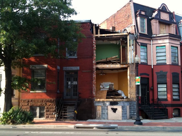
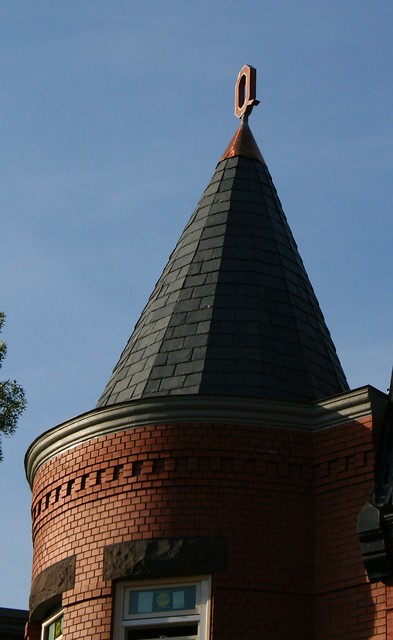
Avenue Q
This summer we wrote about 607 605 Florida Avenue, whose turret was destroyed by a drunk driver in 2006. After four years of legal wrangling and other headaches, the reconstruction is nearly complete.
We took the first photo this summer and took the second photo on Sunday.
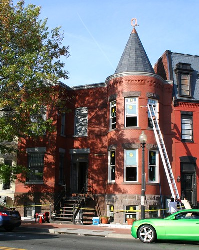
The exterior brickwork is beautiful. The owner, whose last name is Quarterman, has adorned the turret with a copper ‘Q’ finial, adding a distinctive personal touch.
Filming in Progress
Yesterday we posted the three-part oral history interview with Mrs. Lauretta Jackson. It turns out that another neighborhood resident, a professional documentarian, is about to start filming a 30-minute documentary about the neighborhood. When it’s finished, the program will air on DCTV, the District’s public access channel. We’ll let you know when it airs.
In the meantime, are there any facets of LeDroit Park you want to know about or you think might be interesting to feature?
Filming History
Mrs. Lauretta Jackson has lived in LeDroit Park since the 1940s. The Humanities Council of Washington DC, located in the white rowhouse at Vermont Avenue and U Street, sponsored this three-part interview with Mrs. Jackson. It’s truly a fascinating window into the neighborhood’s history. Mrs. Jackson explains the stories behind many of the neighborhood’s notable houses and details the neighborhood’s nineteenth-century birth.
Part 1:
Part 2:
Part 3
How LeDroit Park Came to be Added to the City
The following is a Washington Times article from 1903. The article explains some of the early history of the neighborhood and even includes three photos, the first of which was misidentified as Fifth Street, though we have actually matched it up with Second Street. We have included a few links to related information.

Second Street opposite the Anna J. Cooper House.
HOW LE DROIT PARK CAME TO BE ADDED TO THE CITY
Washington Times
Sunday, May 31, 1903For Many Years the Section of Washington Known by That Name Had Practically Its Separate Government and Had All the Characteristics of a Country Town, Although Plainly Within the Boundary Limits. * * *
In that portion of Florida Avenue between Seventh Street and Eighth Streets northwest where the street cars of the Seventh Street line and the Ninth Street line pass over the same tracks, thousands of passengers are carried every day, and probably but a few if any realize the fact that they are passing over a road older than the organization of the city, a road that dates back to the Revolutionary period— the Bladensburg Road, which connected Georgetown with Bladensburg before the location of the National Capital was determined.
The Map on the Wall.
If the people passing this point will note the little frame building occupied by a florist, 713 Florida Avenue northwest, they will observe that in front of these premises and fastened to the blacksmith shop adjoining is a goodly sized signboard on which is painted an old map of this section and showing the intersection of the old Blandensburg Road and Boundary Street, now known as Florida Avenue. From this map it is seen that Seventh Street Road [now Georgia Avenue] intersects Boundary Street and the old Bladensburg Road at a point about 100 feet east of where the two roads join at an acute angle, and glancing along the lines of Boundary Street and the north lines of some buildings which have been erected in this angle we easily see the direction of the Bladensburg Road and discover that the small building 713 Florida Avenue northwest marks the spot where the Bladensburg Road deflected from Boundary Street and bore off in a northeasterly direction toward Bladensburg.
Once Part of Jamaica Vacancy.
The map referred to is said to be a portion of [the estate named] Jamaica and and Smith’s Vacancy, but if we examine the plats in the office of the Surveyor of the District we will hardly find on file any plats of those sections, but may learn that Le Droit Park was once part of Jamaica and Smith’s Vacancy and possibly a portion of [the estate named] Port Royal. Prior to the cession of the territory now included in the District from Maryland the land known as Jamaica was owned by one Philip R. Fendall, of Virginia. He conveyed this tract of 494 acres on the 12th day of January, 1792, to Samuel Blodgett, jr., of Massachusetts, and from this point the title of the land can be traced down to the present time.
The names attached to the different vacancies establish the names of the various owners of lands adjoining Bladensburg Road at the time it was abandoned as a thoroughfare and taken up as a portion of the farms in that section, and the presence of this old road accounts for some of the peculiar lines in some of the northern boundaries of some of the lots in Le Droit Park. This road crossed Second Street at a point north of Elm Street here. The old plats show Moore’s Vacancy. The road finally joined the present road to Bladensburg at a point where the sixth milestone of the norther line of the District was located.
It is probable that this peculiarly natural boundary of some of the lands which afterward became Le Droit Park may have had something to do with the strange lines which are found in the streets of that suburb, although it was not the intention at the time that Le Droit Park was subdivided to have the streets conform with the city streets.
Site of Campbell Hospital.
During the civil war the territory now contained in Le Droit Park was used as the site of Campbell General Hospital, one of the important hospitals near Washington. The hospital comprised some seventeen separate wooden buildings, erected in the form of a hollow square, with the central portion divided into irregular spaces by buildings cutting across the inclosure and connecting the outside buildings.
The larger dimension of this hospital was fro north to south, and extended from Boundary Street, now known as Florida Avenue, on the south, to the land occupied for many years as a baseball park, situated south of Freedman’s Hospital, and designated on some of the old maps as Levi Park. From east to west the hospital covered the ground from Seventh Street to what is now known as Fifth Street in Le Droit Park, and it is possible that a portion of the space between Fifth Street and Fourth Street was also included in the hospital inclosure.

The McClelland Residence.
At this time there were only two dwellings in the tract known afterward as Le Droit Park— the McClelland and Gilman homestands. Each included about ten acres of land used for grazing and garden purposes. The McClelland property and the Gilman property were divided by a row of large oak trees which were situated about fifty feet apart and continued from Florida Avenue, then Boundary Street, to the northern line of the park.
[See the following 1861 map, a map we extolled several months ago:

]
To the east of the Gilman tract was a narrow strip of land known as the Prather tract. East of this was Moore’s Lane, now Second Street, and still to the east was the tracts of the Moores, George and David, covering the territory as far east as the present location of Lincoln Avenue [now Lincoln Road], on which was located Harewood Hospital, another hospital of considerable note during the civil war.
T.R. Senior, who was commissary at Campbell Hospital, returned to the city some twelve years after the war closed and purchased a residence at the corner of Elm and Second Streets, where he now resides. Members of the family of David McClelland now occupy the old homestead on Second Street.
Following the close of the war it became necessary to provide for such of the freedmen as were in need of assistance. Campbell General Hospital was occupied by the freedmen until August 16, 1869, when the patients were transferred to the new Freedman’s Hospital, which has been erected in connection with Howard University.
The property upon which Freedman’s Hospital stands consisted of a tract of 150 acres and was purchased from John A. Smith. In April, 1867, Howardtown was laid out and soon after some 500 lots were sold, and at this time it seems that the idea was conveyed that streets would be opened to the south through the Miller tract. In April, 1870, the Howard University purchased the Miller tract, and laid out streets to connect the streets of Howardtown with the city streets, and a little later built four houses on the line of what is now known as Fourth Street and in 1872 subdivided the Miller tract, but for some reason the plat was not recorded.
In 1873 the Miller tract was sold by Howard University to A[ndrew] Langdon, and a short time afterward A[mzi] L[orenzo] Barber, formerly secretary of Howard University, became associated with Langdon and hs partner, and by arrangements with D[avid] McClelland, all of the three tracts known as the Miller tract, the McClelland tract, and the Gilman tract were united and subdivided, and in June, 1873, a subdivision known as Le Droit Park was placed on record in the surveyor’s office. A subsequent plat was filed some eighteen months later, in which the proprietors of the subdivision declared it to be their purpose and intention to retain and control the ownership of all the streets platted, and the right to inclose the whole or any portion of the tracts or tract included in the subdivision and to locate and control all entrances and gates to the same.

During the autumn of 1876 A. L. Barber & Co. commenced the erection of fences across the north line of Le Droit Park, and from this time until August, 1891, fences were maintained along the northern line of the park. From 1886 to 1891 frequent fence wars were in operation. The fence across what is now Fourth Street would be removed by one party, and the opposing party would secure an injunction and restore it. This mode of procedure was repeated at various times until in 1901 a compromise verdict was agreed upon by the two factions and the fence was removed, Fourth Street was improved north of the park, and the streets of the park passed into the control of the city after a period of some eighteen years of private ownership.
The organization of Le Droit Park, under the limitations of the plat filed in 1873, was a peculiar experiment, that of the founding of an independent suburb adjoining the city. the southern line of the park was inclosed with a handsome combination iron and wood fence, some of which may now be found on the southern line of the McClelland property. Buildings were erected with plenty of room around them, and during the period from 1873 to 1885 the larger part of the buildings were planned and erected by James H. McGill. Double houses were quite common, but it was not until 1888 that such a thing as a row of houses were known in the park.
Before control of the streets was surrendered to the city the conditions existing in the park resembled closely those found in small country towns. Many of the inhabitants owned cows, which were pastured upon the vacant lots; the women “went a-neighboring,” and the social life savored strongly of a village, and yet it was near the city. The express and telegraph messengers, however, always collected of residents an extra fee for the reason that they lived out of the city.
With the opening of the streets and the introduction of street cars the park soon lost its former characteristics and became part of the city with all of its advantages and disadvantages. The opening of Rhode Island Avenue [from Florida Avenue eastward] spoiled in a measure the former beauty of the McClelland and Gilman homesteads, although there is still much more ground remaining in both of these old tracts that many people would care to own. The opening of Fifth Street will, to some extent, divide the traffic which now finds a way through Fourth Street. Sixth Street ends at Spruce Street [now U Street], and further progress seems barred by the residence, 601 Spruce Street, and there seems no immediate chance of the extension of Third Street above its present limit [at V Street??], where progress is barred by a high fence decorated with the advertisement of a prominent firm.
Former Familiar Street Names.
The old names of the streets of the park, such as Harewood Avenue [now Third Street], Maple Avenue [now U Street], Moore’s Lane [later Le Droit Avenue, then Second Street], Linden Street [now Fourth Street], Larch Street [now Fifth Street], Juniper Street [now Sixth Street], and Bohrer Street [still extant], are nearly forgotten, and have passed away with the fence and its period. The names of the city streets have taken their places, and with the growth of the population the country life and country scenes have given way to those of the city.
Civic Associations Past

Gen. William Birney lived in the mansard-roofed duplex on Anna J. Cooper Circle.
The LeDroit Park Civic Association meets tonight, following a long tradition of meetings to improve the neighborhood. Take a look at this newspaper article from the National Republican published on March 26, 1881:
Improvements Proposed by the Property Owners.
In response to a call issued, there was a very full attendance of the members of Le Droit Park Property Owners’ Association last night in the park. The meeting was called to order by Mr. W. Scott Smith1, the president of the association, who proceeded to state what had been done since the last meeting to promote the interests of the park and the large number of residents living therein. The first business before the association was the election of officers for the ensuing year. On motion of General W. W. Birney2, Mr. W Scott Smith was unanimously re-elected president of the association, Colonel O. H. Irish3 was nominated and elected vice-president; James H. McGill4, secretary; J. J. Albright5, treasurer, and E. B. Barnum6 the additional member of the executive committee. The president said he had recently had an interview with the District Commissioners, and the lighting of two additional gas lamps in the park had been ordered. He had seen the Major and Superintendent of Police about giving the park better police protection, and had received assurances that the matter should receive prompt attention, and an officer detailed specially for night duty in the park.
General Birney submitted a motion, which was adopted, that a vote of thanks be extended to the president of the association for his active efforts during the past year in behalf of the park.
The question of opening a new street on the east side of the Park, running from Boundary street [now Florida Avenue] through to the Soldiers’ Home, then came up, and gave rise to considerable discussion, all concurring in the opinion that such a street was needed. A resolution was the offered and adopted that the members of the association will co-operate heartily with the District Commissioners in securing the opening of such a street and road, and instructing the executive committee to take steps to make effective such co-operation. Attention was directed to the fact that all the houses and a large amount of property in the Park were greatly exposed and jeopardized in case of a fire by the action of the water department in shutting off the pressure of water between the hours of midnight and five o’clock a.m., and thus practically preventing the flow of water in the park. The executive committee were directed to look in the matter and endeavor to have it remedied as soon as possible. The need of a fire-engine in the northern section of the city was regarded as very pressing. After discussing various other matters and directing that rules be prepared for the government and guidance of the special day-policemen, the meeting adjourned.
References
- Private secretary to the Secretary of the Interior; resident of 525 T Street NW. Halford, A. J. Official Congressional Directory. Washington: GPO, 1900.
- Civil War general; resident of 1901 Third Street NW. Read more at Wikipedia.
- Head of the Bureau of Engraving and Printing among other accomplishments; resident of 1907 Third Street NW. National Republican. Washington, Jan. 13, 1879 and Richardson, F. A. Congressional Directory. Washington: GPO, 1880.
- Architect of LeDroit Park.
- Wealthy coal distributor. Cutter, Library Journal. Vol. 17. New York: ALA, 1892.
- Tailor and clothier, E. B. Barnum & Co.; resident of 1883 Third Street NW. Boyd, William Henry. Boyd’s Directory of the District of Columbia. Washington: Boyd, 1887.
LeDroit Park in 1921
We were paging through the excellent online map collection of the Library of Congress and downloaded the 1921 Baist Real Estate Atlas of Washington, DC. This meticulous city atlas marked all the water mains, sewers, streets, squares, lots, and buildings. Buildings were shaded to indicate their construction materials (red for brick, yellow for wood). Subdivision names as well as the names of certain proprietors made their ways into the Baist maps, too.
We’re actually studying this atlas to do some research for an upcoming post on the zoning code, but for your convenience we’ve stitched together the three pages of the atlas covering LeDroit Park and Bloomingdale and published it as a single PDF document. Here are a few highlights.
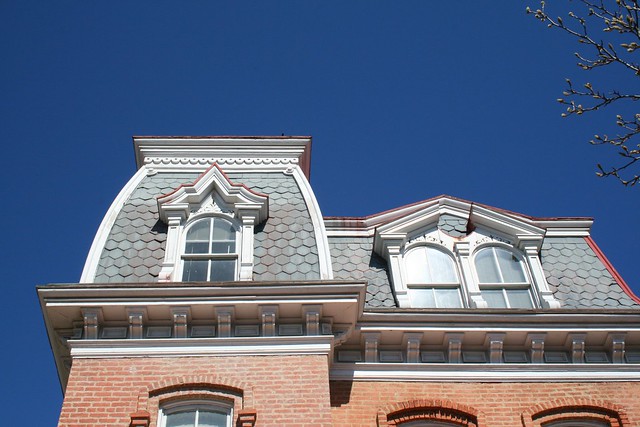
The 400 block of U Street, famous for its houses designed by Washington architect James McGill, reveals that the lots 12, 13, and 14 in square 3081 are wood houses, while all the other McGill houses on the block are brick.

Here’s the original Gage School, now a condo building, on Second Street. Notice the Moore property, which predates the establishment of LeDroit Park, extending all the way south to Florida Avenue.

The current site of the United Planning Organization on Rhode Island Avenue was the estate of engraver David McClelland. As we wrote before, the U.S. War Department confiscated Mr. McClelland’s map of the District at the outbreak of the Civil War. The Elks later purchased the McClelland estate and eventually sold it and moved into their current building on Third Street (marked as Harewood Avenue below).

In the 1970s, the city razed all the area shaded in green below to make way for Gage-Eckington Elementary School, which was itself razed just last year after years of declining enrollment.

Carless in LeDroit

Source: U.S. Census Bureau
Among the nicest features of LeDroit Park are its walkability and its proximity to downtown. We can bike downtown to work in 15 minutes, or if it’s raining, take the bus or the metro and be there in 25 minutes. The restaurants, shops, and bars along U Street are only a short walk away.
The notion that it is easy to live in LeDroit Park without a car consistently confounds many suburbanites, but our variety of transportation options is no accident.
Our neighborhood is just outside the original L’Enfant city. In L’Enfant’s time, the main form of transportation was the human foot, so a city designed from scratch, like Washington, had to be relatively flat, like Washington, and compact, like Washington. Horse-drawn streetcars made commuting across the city easier, and electric streetcars eased the daily climb to neighborhoods like Columbia Heights and Mount Pleasant.
After World War II, housing construction exploded, particularly suburban housing construction. The suburban housing model was— and, for the most part, still is— based on several main principles, most significantly, the uniformity of housing sizes (usually large) and the separation of residential and commercial uses. Both larger lots and the separation of uses create longer distances between any two points, requiring a greater effort to go between home, work, and the grocery store.
These longer distances between daily destinations made walking impractical and the lower population densities made public transit financially unsustainable. The only solution was the private automobile, which, coincidentally, benefited from massive government subsidies in the form of highway building and a subsidized oil infrastructure and industry.
LeDroit Park was founded in 1873 and the first wave of single-family and duplex houses designed by James McGill soon followed. The second housing wave brought rowhouses to LeDroit Park, but most of the neighborhood was finished in the early twentieth century long before the dominance of the automobile.
Notice this 1908 photo of the 400 block of U Street in LeDroit Park. You’ll see four people, but only one car.

It’s no coincidence that our neighborhood’s founding, long before the automobile age, relates to its walkability and abundance of transit options. In fact, when we look at the regional Census data, we find a strong relationship between the age of the housing stock and the rate of households without a car.
The only other factor that might influence the rate of carlessness is income, but the closeness of the carless rate and the pre-war housing stock rate is too glaring to ignore. There are plenty of middle-class people in Washington who choose to forgo a private car and the age of the neighborhood may be a strong indication of just how easy it is to live without a car.
1881 Ad for LeDroit Park
The Library of Congress keeps an online collection of old newspapers to chronicle American history. Look at this 1881 ad for “cottages” in LeDroit Park:

Le Droit Park.—Cottages of six and eight rooms; all the modern conveniences; north and south front; $25 to $30. A. L. Barber & Co., Le Droit building.
Amzi Barber’s office was downtown in the LeDroit Building, which still stands today at 800 F Street NW:


Recent Comments