
Three nearby restaurants earn Michelin “Bib Gourmand” status

French tire manufacture and restaurant critic Michelin released its much-anticipated guide to Washington restaurants. No restaurants earned the top three-star rating, but three restaurants earned two stars, nine earned one star, and 19 restaurants, three of which are nearby, earned “Bib Gourmand” status for their “exceptional good food at moderate prices.”
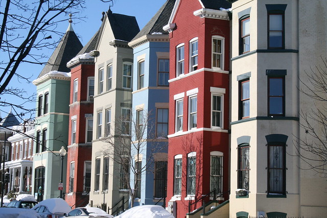
LeDroit’s very own Royal (501 Florida Avenue NW) earned Bib Gourmand status. I frequently visit the royal for breakfast on weekends. Their coffee is decent and the breakfast pastries and arepas are great. A friend in West End routine visits for breakfast.
Red Hen (1822 First Street NW), just one block east of LeDroit Park, is another Bib Gourmand venue and is one of my favorite dinner spots. The menu is Italian and the pasta is deliciously fresh. Red Hen can get crowded, but you can often squeeze yourself around its peninsular bar, where you may eat dinner and drink.
If you’re looking for eclectic Chinese-French fusion, walk over to Kyirisan (1924 8th Street NW), one block west of LeDroit Park. The Tim Ma restaurant opened in March and the Post’s Tom Sietsema gave it a good review.
The nearest starred restaurants are the excellent Dabney (122 Blagden Alley NW) and Kinship (1015 7th Street NW), both near the Convention Center. Such proximity to highly rated restaurants would have been absolutely unthinkable when I moved to LeDroit Park in 2009. How times have changed.
McMillan Fountain ready for its close-up
As part of DC Water’s construction work on the First Street Tunnel, the agency paved a temporary parking lot on the grounds of the McMillan Reservoir. Community leaders took a tour of the tunnel project on Saturday and got a close-up photo of the top of the McMillan Fountain, which stands just beyond the parking lot fence.
The base of the fountain, pictured below as it originally stood, lies dismantled in Fort Washington National Park in Prince George’s County.

Meet me (and your neighbors!) at Costa Brava on Tuesday

LeDroit Park’s next monthly happy hour will be at Costa Brava (1837 First Street NW) in Bloomingdale on Tuesday, February 10, from 6:30 to 8:30 pm. We will be at the upstairs bar. All neighbors are welcome to attend.
Restaurant Costa Brava and Howard Univ. present tonight
The January meeting of the LeDroit Park Civic Association is tonight at 7 pm in the basement of the Florida Avenue Baptist Church (enter at U Street and Bohrer Street).
The owner of Costa Brava (1837 First St NW) will introduce the neighborhood to his new Catalonian restaurant. I had dinner at the restaurant late last year and I highly recommend it.
Howard University representatives will propose changes to university policy regarding student conduct and public safety:
- Expanding the area around the campus deemed subject to the reporting of crime statistics.
- Giving universities broader authority to address student misconduct that takes place off-campus.
- Giving the Mayor or a university President the ability to request the assistance of other campus police personnel in cases of emergency, thus allowing the Metropolitan Police Department to focus their resources elsewhere.
The meeting will also include the usual committee reports and a community open forum. Everyone is welcome to attend.
Mayor Gray announces a task force to address area flooding

Later this morning, Mayor Vincent Gray, Councilmember Kenyan McDuffie (D – Ward 5), and representatives from DC Water and District agencies, will announce the creation of a task force to address the flooding that has occurred in numerous basements in LeDroit Park and Bloomingdale since July.
The mayor and councilmember will hold the press conference today at 11:30 am at the park at triangle park at First Street and Florida Avenue NW.
During several downpours in July, the overtaxed sewers below Florida Avenue in LeDroit Park and below several streets in Bloomingdale backed up into residents’ basements.
DC Water, the semi-independent agency that manages the drinking water and sewer infrastructure, says the completion of new diversion sewer tunnels in 2025 will solve the problem for good. Waiting 13 years is little consolation for residents whose basements have flooded with diluted sewage.
Storm floods streets and basements of Bloomingdale
During torrential downpours the Bloomingdale neighborhood experiences flooding. Yesterday evening’s storm flooded numerous Bloomindale basements and the intersection of Rhode Island Avenue, T Street, and First Street NW.
The Boundary Stone restaurant (116 Rhode Island Avenue NW) posted a photo of a flooded Rhode Island Avenue NW.
Why did this section of the street flood? DC Water, which runs the water pipes, sewers, and storm drains, blames the lack of pipe capacity in Bloomingdale.
A closer look at the 1861 Boschke map of the District of Columbia reveals that the northern reaches of Tiber Creek flowed right through Bloomingdale. In fact the creek flowed right where Rhode Island Avenue flooded at T Street NW.

Boschke map with modern streets superimposed
Whether the creek still flows underground in this location is something I will leave to experts. However, creeks, like all water, flow to the lowest point on the land. The creek’s former presence at this location suggests that the terrain slopes downward on all sides, directing rainwater to this critical flood point.
Ward 5 Councilmember Kenyan McDuffie (D) was on the scene and DC Water has promised to brief him soon on their Bloomingdale flood solution, which they say is on the way. Though this degree of flooding is rare, Bloomingdale residents will surely welcome and demand a permanent fix.
Battle ensues over control of Crispus Attucks Park

Crispus Attucks Park by rockcreek, on Flickr
The Post is running an article about the battle over control of Crispus Attucks Park in Bloomingdale. The park is a hidden gem in Bloomingdale. It’s embedded in the middle of the block bounded by North Capitol Street, U Street NW, V Street NW, and First Street NW.
The park is on land once owned by C & P Telephone, but which was transferred to a non-profit in the 1970s. But who controls the non-profit that controls the park? Aye, there’s the rub.
Bikeshare expansion passes over LeDroit Park
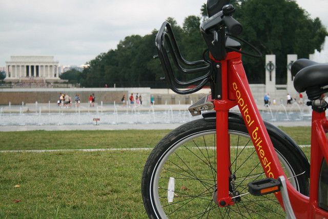
Capital Bikeshare, the District’s smashingly successful bikesharing system, will expand this fall. Unfortunately, the expansion plans for this fall exclude LeDroit Park.
The District and Arlington launched the system a year ago with 14 stations in Arlington and 100 in the District. This fall, DDOT will add 34 stations in the District. In our area, DDOT will add a station by the Shaw Library and another at 1st Street NW and Rhode Island Avenue NW in Bloomingdale.
These additions should help alleviate the pressure placed on the existing stations at 7th & T Streets NW in Shaw and at Florida Avenue and R Street NW in Bloomingdale. Currently, LeDroiters and Bloomingdalers compete to use these two stations and thus frequently leave the stations empty or full during rushhour.

Last week DDOT Director Terry Bellamy announced that the district will add 50 stations early next year. We hope that in this new round DDOT focuses more attention on LeDroit Park and other neighborhoods in ANC 1B.
For instance, a Capital Bikeshare station could easily go in at the Park at LeDroit’s south entrance at 3rd and Elm Streets NW. This location is central to the neighborhood and could bring some extra eyes to the park throughout the day.
Outside of LeDroit Park, there is a noticeable station gap in the northern reaches of Bloomingdale and around Cardozo High School.
Capital Bikeshare is particuarly successful in our part of DC for several reasons:
- Car ownership is relatively low compared to the rest of the nation, region, and city. This inclines people to bike more.
- Parking is particularly difficult on many neighborhood streets, thus making cycling more attractive.
- The historical development of this area has permitted the close proximity of commercial uses to residential uses. This means trips to shops and restaurants are short and easily made by bike.
- Downtown is a short ride away and biking is often faster than taking the bus.
Bloomin’ Road Rage
The driver of a car intentionally hit a cyclist at First Street and Florida Avenue NW in Bloomingdale, TheWashCycle reports. The victim wrote:
Around 5:50 PM [Wednesday] I was riding along First St. NW with other commuters. We crossed over Florida Ave and a car came in behind me, horn continuously on, and accelerated into my rear wheel knocking me to the ground. The driver then got out of the car and yelled some obscenity at me. He got back into his car and left the scene.
I ended up with a few bruises and bumps but luckily no serious injury, but my rear wheel was destroyed along with my saddle, still not sure about the frame. Although there were seven plus witnesses, we were only able to get a partial license plate. We did get a great description of the car. The police arrived on the scene and took all the witness statements, etc and the incident will be filed as a hit and run.
Using a vehicle as a weapon is a serious crime. It’s also important to remember that cyclists and drivers are equally entitled to use the streets of the city.
Old Maps: The District Before LeDroit Park (1792 – 1859)
This is the first in a series of posts about historic maps of LeDroit Park.
When the Federal Government established the national capital, it was to be located within a 100-square-mile diamond straddling both sides of the Potomac. In fact, the City of Washington was just one of several established cities and settlements in the nascent Federal District, later called the District of Columbia. The City of Washington, as defined by Congress and Peter L’Enfant’s plan, was bounded by the Potomac River and Rock Creek to the west, the Anacostia River to the south and east, and by Boundary Street (now Florida Avenue) to the north. LeDroit Park sits just north of Florida Avenue, in what was originally the rural Washington County, District of Columbia. The District also included the City of Georgetown, the City of Alexandria, and Alexandria County (now Arlington County, Virginia).
The map below, dating from 1792, was the first printed version of the L’Enfant Plan (as amended by Andrew Ellicott) for the City of Washington. Notice that its northern boundary coincides with what is now Florida Avenue. LeDroit Park now sits just to the west of what is marked as “Tiber Creek”. The creek, also called Goose Creek before the founding of the city, originally ran between First and Second Streets NW through Bloomingdale all the way to what is now Constitution Avenue NW, and westward toward the Washington Monument grounds, where it emptied into the Potomac River. Much of the creek is now buried in pipes beneath the city.
 Download the full version of this map from the Library of Congress
(We have a reliable method of identifying the future LeDroit Park on old maps of Washington: look for New Jersey Avenue NW, which runs diagonally to the northwest from the Capitol. Directly north of where it ends at the city’s border is where LeDroit Park would later be built.)
The capital city grew slowly over the coming decades with new residents, including government workers and Members of Congress, housed in newly constructed houses and boarding houses near the White House and Capitol, respectively. The difficulty in finding enough skilled labor to build a capital city required the leasing of slaves, who were instrumental in constructing many of the grand public buildings that stand today.
It would be a mistake to look at the map above and assume that all the new streets and canals were built together. In fact, the L’Enfant Plan was just that, a plan. The grand, spacious avenues required the clearing of trees and brush after a tedious survey to match the ground with the map.
In fact, by 1842 so much of the city was incomplete that a visiting Charles Dickens belittled Washington as a “city of magnificent intentions” marked by
spacious avenues, that begin in nothing and lead nowhere; streets, mile-long, that only want houses, roads, and inhabitants; public buildings that need but a public to be complete; and ornaments of great thoroughfares, which only lack great thoroughfares to ornament.
Whereas the global financial markets of today allow developers to develop large tracts of land at once, 19th-century cities had to be built piecemeal with speculation limited to small projects. LeDroit Park was no different: only several houses and only a few streets were built at first with the rest to come later.
From 1856 to 1859, German cartographer Albert Boschke charted the District hoping to sell his maps to the U.S. Government. His 1859 map of the City of Washington (below) provided illustrative evidence supporting Charles Dickens’s sneer. Much of Washington, especially its northern reaches near what was to become LeDroit Park, sat undeveloped with only a few cleared streets.
") Download the full version of this map from the Library of Congress. To aid orientation, we have superimposed a few street names.
Download the full version of this map from the Library of Congress. To aid orientation, we have superimposed a few street names.
The only clear north-south street was Seventh Street, which connected the city with the rural county and stretched into Maryland (albeit under different names). At R Street— if one could call it a street— it crossed an open creek that ran through the right-of-way.
Seventh Street’s primacy as the main north-south thoroughfare actually contradicts the intention of the L’Enfant Plan, whose Baroque determination to provide a “reciprocity of sight“, plotted Eighth Street, not Seventh Street, as the more important axis. In fact to this day the right-of-way of Eighth Street is fifteen feet wider than those of Seventh and Ninth Streets, even though Eight carries only a fraction of the traffic burden that the parallel streets carry.
It is difficult to enforce one artistic vision on a democracy; the shifting of axes, from Eighth to Seventh, merely reflects the fact that cities are shaped by their inhabitants in ways the founders never anticipate. The future LeDroit Park was no different.
Next: Alfred Boschke maps the entire District and a future LeDroit Park resident prints it, only to have it seized at gunpoint.


Recent Comments