
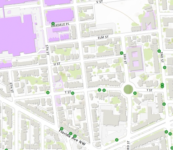
DDOT to plant 16 trees in LeDroit Park this fall

Fall is a good time to plant trees. DDOT has released its tree-planing map and LeDroit Park is slated to receive 16 trees. The agency only plants trees in public space, meaning the trees will be planted in the tree boxes or planting strips between the sidewalks and the curbs.
- 501 T Street
- 406 T Street
- 324 T Street
- 318 T Street
- 471 Florida Avenue
- 1934 3rd Street
- 1842 2nd Street
- Opposite 1915 2nd Street
- Opposite 1919 2nd Street
- 1948 2nd Street
- 1929 2nd Street
- 329 Rhode Island Avenue
- 455 Florida Avenue
Sweetgum (Slender Silhouette cultivar)
- 453 Florida Avenue
- Opposite 432 Oakdale Place
Cherry tree (Snow Goose cultivar)
- Southwest circumference of Anna Cooper Circle
Storm floods streets and basements of Bloomingdale
During torrential downpours the Bloomingdale neighborhood experiences flooding. Yesterday evening’s storm flooded numerous Bloomindale basements and the intersection of Rhode Island Avenue, T Street, and First Street NW.
The Boundary Stone restaurant (116 Rhode Island Avenue NW) posted a photo of a flooded Rhode Island Avenue NW.
Why did this section of the street flood? DC Water, which runs the water pipes, sewers, and storm drains, blames the lack of pipe capacity in Bloomingdale.
A closer look at the 1861 Boschke map of the District of Columbia reveals that the northern reaches of Tiber Creek flowed right through Bloomingdale. In fact the creek flowed right where Rhode Island Avenue flooded at T Street NW.

Boschke map with modern streets superimposed
Whether the creek still flows underground in this location is something I will leave to experts. However, creeks, like all water, flow to the lowest point on the land. The creek’s former presence at this location suggests that the terrain slopes downward on all sides, directing rainwater to this critical flood point.
Ward 5 Councilmember Kenyan McDuffie (D) was on the scene and DC Water has promised to brief him soon on their Bloomingdale flood solution, which they say is on the way. Though this degree of flooding is rare, Bloomingdale residents will surely welcome and demand a permanent fix.
Trader Joe’s coming to 14th & U

It looks like 2013 will be a harvest year for LeDroit Park residents as two new grocery stores open nearby. DCist broke the news that Trader Joe’s will open a store at the Louis building now under construction at the southwest corner of 14th and U.
Located at just under a mile’s walk from Anna J. Cooper Circle, the new store will provide another grocery option to area residents.
TJ’s prices are competitive with many other stores and the TJ’s specializes in unusual and somewhat exotic foods in addition to the usual staples. TJ’s main weakness lies in its produce selection, which, judging from experiences at the Trader Joe’s in the West End, is limited.
The store’s opening next year will also be accompanied by the opening of the 60,000 square-foot Giant at the CityMarket project at 7th and P Streets in Shaw. Once these two projects open, all the major grocery store chains in the area will be located no more than 1.1 mi. from LeDroit Park.
| Store | Location | Distance (mi) |
|---|---|---|
| Giant (opening 2013) | 7th & P Streets NW | 0.6 |
| Trader Joe’s (opening 2013) | 14th & U Streets NW | 0.9 |
| Safeway | 5th & L Streets NW | 0.9 |
| Harris Teeter | 1st & M Streets NE | 1.0 |
| Whole Foods | 1400 blk. P Street NW | 1.1 |
Even still I dream of a full-service grocery store opening up at the long-stalled Howard Town Center project at Georgia Avenue and V Street. The project, in the planning stages for many years, has been perpetually delayed by disagreements between Howard University and its development partner.
The UPO building on Rhode Island Avenue used to be a Safeway many years ago. The site is large enough to be redeveloped into a modern, urban grocery store if parking is placed underground. In fact the second floor could house UPO’s offices.
Until those dreams come true, the nearest full-service grocery stores are a long, but manageable walk.
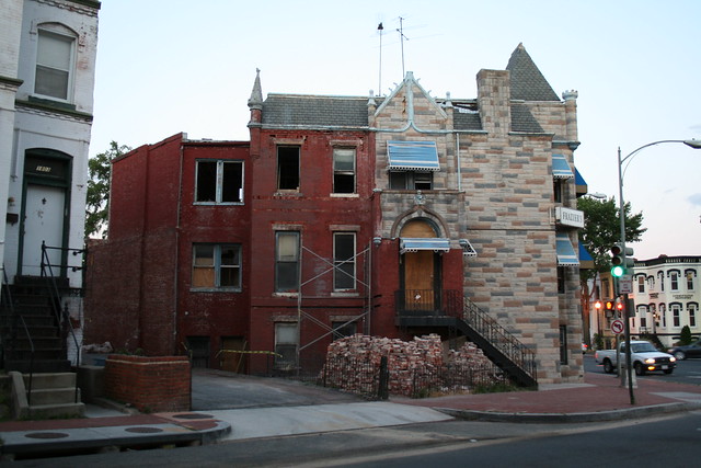
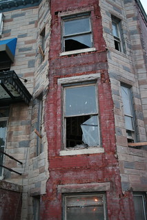
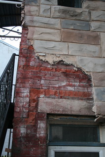
The death of FormStone
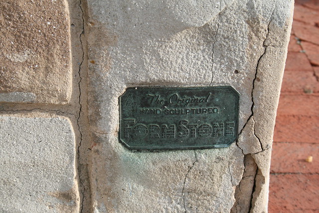
Formstone, that faux-stone façade that became popular in the 1930s and ’40s, can be removed, but it’s not easy. The old Frazier’s Funeral Home, at 389 Rhode Island Avenue, has been vacant for several years since the District shut it down. The new owner is renovating the property to convert into 4 or 5 residential units.
Part of the renovation involves removing the Formstone façade and repairing the brick beneath.
LeDroit residents tell their stories
 Who are your neighbors? In December, LeDroit Park resident Robert Sullivan launched a website Portait City that features audio and photographic profiles of several LeDroit Park residents. You may not know these subjects personally and perhaps maybe you have seen them in the neighborhood. Nonetheless, they each provide a fascinating mosaic of LeDroit Park.
Interview subjects include Bobby Donaldson, the South Carolina native who opened B&J Barbeque at Rhode Island Avenue and 3rd Street. You’ll find out what inspired him to open a restaurant and what people like in their barbeque.
LeDroit resident and former Ward 1 councilmember Frank Smith spent part of his youth as a civil rights worker in rural Mississippi. Mr. Smith recorded and reported civil rights abuses, such as bogus “literacy tests” that southern states used to prohibit black residents from voting. Here how he reacted to Marion Barry’s infamous arrest.
Hear from the Elks Lodge and their relationship with the neighborhood. You can also hear Elks reminisce about performances at the Howard Theatre back in the day.
The flamboyantly dressed “Hollywood” explains his eclectic attire and Bloomingdaler John Salatti sings the praises of his wife and Bloomingdale.
Finally, Robert was able to interview LeDroit residents Dolores Baylor and her daughter Mechelle just before Dolores died in December. Mechelle explains what it was like growing up in the neighborhood and Dolores recounts what it was like living through the riots of 1968.
The lives of famous figures in history are well-documented, but it is also important to record the experiences and views of the not-so-famous. Robert contracted your author, who is a professional web developer by day, to build the site. While building the site, we couldn’t help but notice that each story delivered its own unexpected poignancy.
Bikeshare expansion passes over LeDroit Park
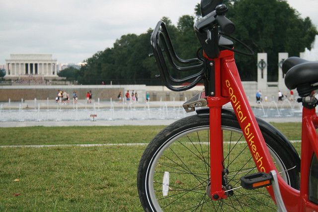
Capital Bikeshare, the District’s smashingly successful bikesharing system, will expand this fall. Unfortunately, the expansion plans for this fall exclude LeDroit Park.
The District and Arlington launched the system a year ago with 14 stations in Arlington and 100 in the District. This fall, DDOT will add 34 stations in the District. In our area, DDOT will add a station by the Shaw Library and another at 1st Street NW and Rhode Island Avenue NW in Bloomingdale.
These additions should help alleviate the pressure placed on the existing stations at 7th & T Streets NW in Shaw and at Florida Avenue and R Street NW in Bloomingdale. Currently, LeDroiters and Bloomingdalers compete to use these two stations and thus frequently leave the stations empty or full during rushhour.

Last week DDOT Director Terry Bellamy announced that the district will add 50 stations early next year. We hope that in this new round DDOT focuses more attention on LeDroit Park and other neighborhoods in ANC 1B.
For instance, a Capital Bikeshare station could easily go in at the Park at LeDroit’s south entrance at 3rd and Elm Streets NW. This location is central to the neighborhood and could bring some extra eyes to the park throughout the day.
Outside of LeDroit Park, there is a noticeable station gap in the northern reaches of Bloomingdale and around Cardozo High School.
Capital Bikeshare is particuarly successful in our part of DC for several reasons:
- Car ownership is relatively low compared to the rest of the nation, region, and city. This inclines people to bike more.
- Parking is particularly difficult on many neighborhood streets, thus making cycling more attractive.
- The historical development of this area has permitted the close proximity of commercial uses to residential uses. This means trips to shops and restaurants are short and easily made by bike.
- Downtown is a short ride away and biking is often faster than taking the bus.
Census data for LeDroit Park
In preparation for redistricting Ward 1’s ANCs, the DC Office of Planning has released block-by-block demographic data for the District. We have combined the data for the blocks that comprise LeDroit Park to create a LeDroit Park census.
Analyzing U.S. Census data for LeDroit Park proves difficult because the of the way census tracts are drawn. Our census tract, 34, combines LeDroit Park and Howard University. Dorms on the northern end of the campus, far away from LeDroit Park, account for 717 of the tract’s 4,347 residents, thus skewing tract data. Furthermore, the tract also inclues several blocks bounded by Rhode Island Avenue NW, Florida Avenue NW, and 2nd Street NW.
Fortunately, the Census Bureau provides data for each block, allowing us to combine the statistics for those blocks in LeDroit Park, while excluding the Howard University campus. In the map below, we have outlined the tract in blue and shaded the blocks for LeDroit Park in red.
View LeDroit Park Census in a larger map
Though LeDroit Park started out as an exclusively white suburban neighborhood, by 1910 the neighborhood was almost entirely black. Today, 100 years later, the neighborhood is 70% black and is continuing to diversify.

However, when looking at the numbers on a block-by-block basis, you see that the neighborhood demography, must like that of the District itself, is unevenly distributed.
The block bounded by 5th Street, T Street, 6th Street, and U Street is 53% white, the highest in the neighborhood. Likewise, the block containing the Kelly Miller public housing is 91% black, the highest percentage in the neighborhood. The block containing the arch and the Florida Avenue Baptist Church comes closest to black-white equilibrium at 44% and 49% for each group respectively.

When looking at total population numbers for each block, you see that the two most populous blocks contain Howard University dorms. The block bounded by 2nd Street, T Street, 3rd Street, and Elm Street has 382 residents and contains Slowe Hall, which houses 299 students.
The second most populous block contains the new park. However, it also contains Carver Hall, which itself houses 173 students. Certainly these blocks are big, but the fact that their population numbers are off the chart has more to do with student dorms than with any inherent difference in housing density.

Finally, when we look at housing vacancy, we see that the block bounded by 5th Street, T Street, 6th Street and U Street has 38% of its housing units vacant. We’re not sure what’s causing this number, but we suspect that the apartment building at 5th and U Streets NW boosted the vacancy rate. The building has since been finished and is fully rented.
The block with the second-highest rate of vacancy contains the now-renovated Ledroit Place condo building at 1907 3rd Street NW.

It would be interesting too look at other data, including household income, car ownership, and age distribution for the neighborhood. However, the Office of Planning’s spreadsheet only covered population numbers, racial distribution, and housing unit numbers, so those are the metrics we graphed.
Should DC allow more angle parking on Sunday mornings?
Councilmember Harry Thomas, Jr. (D — Ward 5) introduced a bill to ease Sunday parking tensions by permitting angle parking for religious institutions with ANC and DDOT approval. The councilmember held a forum on the bill and its companion commercial district bill last week.
In DC neighborhoods where street parking is at a premium, few things raise a resident’s ire like church congregants who park illegally on Sunday mornings. Congregants who drive from other parts of the District, from Maryland, and from Virginia have been known to double-park, park in alleys, block crosswalks, and block fire hydrants.
After receiving numerous complaints from residents, Mr. Thomas introduced the bill to primarily allay residents in Bloomindale and Eckington. Since these neighborhoods are among Ward Five’s most densely populated, they, like LeDroit Park, suffer from high street parking occupancy. Last week in Eckington, Mr. Thomas hosted a forum on his bills and took questions from residents.
Mr. Thomas acknowledged what residents have long known: parking enforcement around churches is intentionally lax on Sundays. Though Mr. Thomas admitted the unique challenges to transportation on Sunday mornings, he also decried congregants who park illegally, block residents in, and hinder public safety.
Transit service reaches its nadir on Sunday mornings, and churchgoers often travel to churches in residential neighborhoods with light Sunday service. Since transit service and car traffic are relatively low on Sunday mornings, Mr. Thomas thinks DDOT will be able to find instances of roadways wide enough to accommodate both angle parking and through traffic on Sunday mornings. In each case, though, DDOT will make the final determination of what is safe and permitted, even if an ANC supports the petition.

Left: typical curbside parking. Right: possible angle parking
We asked Mr. Thomas why he singled out angle parking and not other non-traditional parking arrangements and he admitted that the bill was just a first draft and could be expanded to include other measures.
For instance, DDOT permits parking beside the median on Sundays on the 1300 and 1400 blocks of New York Avenue NW downtown. This arrangement works since there is still one lane available for through traffic and since Sunday morning traffic flows are small. A similar arrangement might work along other multi-lane avenues in the District, including Rhode Island Avenue.
In other cases, solutions could be less radical. The congregants of several churches on Florida Avenue park in the right lane on Sunday morning even where parking is never permitted at any time. DDOT may be able to simply change the signs and permit curbside parking in such places on Sunday mornings. The extra parking can act as a traffic-calming measure, though, as we know, easier parking can induce more driving.
No matter what happens, the Department of Public Works, the primary agency in charge of parking enforcement, needs to end its practice of lax Sunday enforcement near churches. Only DDOT, not pastors and not congregants, should make the determination as to what constitutes safe Sunday morning parking. Mr. Thomas acknowledged that the law needs to be enforced uniformly as it is unfair to overlook, as one resident noted, illegal parking in residential neighborhoods, while actively ticketing illegal parking downtown on Sundays.
Though residents expressed frustration with some, though not all, neighborhood churches, Mr. Thomas rightly advised residents that parking tensions need not be adversarial. In fact, he called attention to instances in which neighborhood residents and churches collaborated to resolve parking problems. This can include urging pastors to rent unused lots for their congregants or to provide shuttle service from satellite lots or from congregants’ homes. He even touted bikesharing several times but said it is not practical for everyone.
Whatever the solution, Mr. Thomas admitted the bill was in its infancy and that he wants to provide a template for cooperation; angle parking may be one of many possible solutions.
Mr. Thomas was eager to mention the companion bill to allow permanent angle parking in business districts. Though most meeting attendees were there to complain about church parking in residential neighborhoods, Mr. Thomas said that many Ward 5 businesses depend heavily on customers arriving by private car. However, when he asked a local business owner how much of his business is from outside his neighborhood, the owner said that very little came from elsewhere.
The business corridor bill is significantly different from the Sunday parking bill. The former would permit businesses to seek diagonal parking at all times, regardless of transit service, or if the street space could be reallocated to bike lanes or wider sidewalks.
The Sunday parking bill carries more merit than the business corridor bill because of the unique circumstances of church locations and Sunday transit service. The business corridor bill, in contrast, too hastily and disproportionately prioritizes parking to the detriment of other road uses.
New Condos Coming to Shaw and 14th Street

Florida Avenue elevation for Douglas Development's proposal for 2221 Fourteenth Street NW
The monthly meeting of ANC1B will be on Thursday, December 2 at 7pm in the Reeves Building at Fourteenth and U Streets NW. Here are some of the highlights from the agenda:
Development/Public Space
The commission will likely support the zoning relief application for 2221 14th Street NW (image above). In a rare residential foray, Douglas Development seeks to build a condo building at the southeast corner of Fourteenth Street and Florida Avenue. The company is seeking support for several variances and special exceptions, mostly regarding the roof structure, rear setback, and parking requirements. View the designs and zoning application.
 The commission is also likely to lend its support to the Arts District Branding Project, which is developing graphic banners (sample at right) to hang from lights posts along Fourteenth Street and U Street. The banner is part of a $200,000 city-funded branding project to enhance the marketing and identity of the arts district that stretches along Fourteenth Street from Rhode Island Avenue to Florida Avenue and along U Street from Seventeenth Street to Seventh Street.
DDOT prefers that private groups obtain ANC support before the agency permits groups to hang banners on poles for 90 – 180 days. After the 180-day term, the banners remain up until another group wishes to use the poles or until the group removes them.
Also on the agenda is the District-owned Parcel 39 at the southwest corner of Eighth and T Streets in Shaw. The site is currently a parking lot, but Mayor Fenty, in the waning days of his mayoralty, is seeking to sell the lot to a development team with plans to construct a four-unit condo building. The sale price, or proposed sales price, has not yet been disclosed.
Alcohol Licenses
Two licensees are looking to modify their licenses:
Alero Restaurant & Lounge (1301 U Street) looks to amend its Class C license to include a 44-seat sidewalk café serving alcohol from 11:30 am to 1 am Sunday through Saturday.
Nearby, the Islander Caribbean Restaurant & Lounge (1201 U Street) wants to extend its hours and expand to the second floor. Currently their hours are Sunday 10 am- 2 am and Thursday-Saturday 10 am-2 am. They propose these new hours: Sunday through Saturday, 6 am-4 am with alcohol served Sunday 10 am-2 am, Monday-Thursday 8 am-2 am, and Friday – Saturday 8 am-3 am.
The commission will likely renew the following licenses as a formality:
- Duffy’s Irish Restaurant (2106 Vermont Avenue)
- Hominy/Bohemian Caverns (2001 11th Street)
- Dickson Wine (903 U Street)
- Velvet Lounge (915 U Street)
- Indulj (1208 U Street)
- Desperados Pizza (1342 U Street)
- Patty Boom Boom (1359 U Street)
- Marvin (2007 14th Street)
- The Gibson (2009 14th Street)
- Café Collage (1346 T Street)
- Jin (2017 14th Street)
How LeDroit Park Came to be Added to the City
The following is a Washington Times article from 1903. The article explains some of the early history of the neighborhood and even includes three photos, the first of which was misidentified as Fifth Street, though we have actually matched it up with Second Street. We have included a few links to related information.

Second Street opposite the Anna J. Cooper House.
HOW LE DROIT PARK CAME TO BE ADDED TO THE CITY
Washington Times
Sunday, May 31, 1903For Many Years the Section of Washington Known by That Name Had Practically Its Separate Government and Had All the Characteristics of a Country Town, Although Plainly Within the Boundary Limits. * * *
In that portion of Florida Avenue between Seventh Street and Eighth Streets northwest where the street cars of the Seventh Street line and the Ninth Street line pass over the same tracks, thousands of passengers are carried every day, and probably but a few if any realize the fact that they are passing over a road older than the organization of the city, a road that dates back to the Revolutionary period— the Bladensburg Road, which connected Georgetown with Bladensburg before the location of the National Capital was determined.
The Map on the Wall.
If the people passing this point will note the little frame building occupied by a florist, 713 Florida Avenue northwest, they will observe that in front of these premises and fastened to the blacksmith shop adjoining is a goodly sized signboard on which is painted an old map of this section and showing the intersection of the old Blandensburg Road and Boundary Street, now known as Florida Avenue. From this map it is seen that Seventh Street Road [now Georgia Avenue] intersects Boundary Street and the old Bladensburg Road at a point about 100 feet east of where the two roads join at an acute angle, and glancing along the lines of Boundary Street and the north lines of some buildings which have been erected in this angle we easily see the direction of the Bladensburg Road and discover that the small building 713 Florida Avenue northwest marks the spot where the Bladensburg Road deflected from Boundary Street and bore off in a northeasterly direction toward Bladensburg.
Once Part of Jamaica Vacancy.
The map referred to is said to be a portion of [the estate named] Jamaica and and Smith’s Vacancy, but if we examine the plats in the office of the Surveyor of the District we will hardly find on file any plats of those sections, but may learn that Le Droit Park was once part of Jamaica and Smith’s Vacancy and possibly a portion of [the estate named] Port Royal. Prior to the cession of the territory now included in the District from Maryland the land known as Jamaica was owned by one Philip R. Fendall, of Virginia. He conveyed this tract of 494 acres on the 12th day of January, 1792, to Samuel Blodgett, jr., of Massachusetts, and from this point the title of the land can be traced down to the present time.
The names attached to the different vacancies establish the names of the various owners of lands adjoining Bladensburg Road at the time it was abandoned as a thoroughfare and taken up as a portion of the farms in that section, and the presence of this old road accounts for some of the peculiar lines in some of the northern boundaries of some of the lots in Le Droit Park. This road crossed Second Street at a point north of Elm Street here. The old plats show Moore’s Vacancy. The road finally joined the present road to Bladensburg at a point where the sixth milestone of the norther line of the District was located.
It is probable that this peculiarly natural boundary of some of the lands which afterward became Le Droit Park may have had something to do with the strange lines which are found in the streets of that suburb, although it was not the intention at the time that Le Droit Park was subdivided to have the streets conform with the city streets.
Site of Campbell Hospital.
During the civil war the territory now contained in Le Droit Park was used as the site of Campbell General Hospital, one of the important hospitals near Washington. The hospital comprised some seventeen separate wooden buildings, erected in the form of a hollow square, with the central portion divided into irregular spaces by buildings cutting across the inclosure and connecting the outside buildings.
The larger dimension of this hospital was fro north to south, and extended from Boundary Street, now known as Florida Avenue, on the south, to the land occupied for many years as a baseball park, situated south of Freedman’s Hospital, and designated on some of the old maps as Levi Park. From east to west the hospital covered the ground from Seventh Street to what is now known as Fifth Street in Le Droit Park, and it is possible that a portion of the space between Fifth Street and Fourth Street was also included in the hospital inclosure.

The McClelland Residence.
At this time there were only two dwellings in the tract known afterward as Le Droit Park— the McClelland and Gilman homestands. Each included about ten acres of land used for grazing and garden purposes. The McClelland property and the Gilman property were divided by a row of large oak trees which were situated about fifty feet apart and continued from Florida Avenue, then Boundary Street, to the northern line of the park.
[See the following 1861 map, a map we extolled several months ago:

]
To the east of the Gilman tract was a narrow strip of land known as the Prather tract. East of this was Moore’s Lane, now Second Street, and still to the east was the tracts of the Moores, George and David, covering the territory as far east as the present location of Lincoln Avenue [now Lincoln Road], on which was located Harewood Hospital, another hospital of considerable note during the civil war.
T.R. Senior, who was commissary at Campbell Hospital, returned to the city some twelve years after the war closed and purchased a residence at the corner of Elm and Second Streets, where he now resides. Members of the family of David McClelland now occupy the old homestead on Second Street.
Following the close of the war it became necessary to provide for such of the freedmen as were in need of assistance. Campbell General Hospital was occupied by the freedmen until August 16, 1869, when the patients were transferred to the new Freedman’s Hospital, which has been erected in connection with Howard University.
The property upon which Freedman’s Hospital stands consisted of a tract of 150 acres and was purchased from John A. Smith. In April, 1867, Howardtown was laid out and soon after some 500 lots were sold, and at this time it seems that the idea was conveyed that streets would be opened to the south through the Miller tract. In April, 1870, the Howard University purchased the Miller tract, and laid out streets to connect the streets of Howardtown with the city streets, and a little later built four houses on the line of what is now known as Fourth Street and in 1872 subdivided the Miller tract, but for some reason the plat was not recorded.
In 1873 the Miller tract was sold by Howard University to A[ndrew] Langdon, and a short time afterward A[mzi] L[orenzo] Barber, formerly secretary of Howard University, became associated with Langdon and hs partner, and by arrangements with D[avid] McClelland, all of the three tracts known as the Miller tract, the McClelland tract, and the Gilman tract were united and subdivided, and in June, 1873, a subdivision known as Le Droit Park was placed on record in the surveyor’s office. A subsequent plat was filed some eighteen months later, in which the proprietors of the subdivision declared it to be their purpose and intention to retain and control the ownership of all the streets platted, and the right to inclose the whole or any portion of the tracts or tract included in the subdivision and to locate and control all entrances and gates to the same.

During the autumn of 1876 A. L. Barber & Co. commenced the erection of fences across the north line of Le Droit Park, and from this time until August, 1891, fences were maintained along the northern line of the park. From 1886 to 1891 frequent fence wars were in operation. The fence across what is now Fourth Street would be removed by one party, and the opposing party would secure an injunction and restore it. This mode of procedure was repeated at various times until in 1901 a compromise verdict was agreed upon by the two factions and the fence was removed, Fourth Street was improved north of the park, and the streets of the park passed into the control of the city after a period of some eighteen years of private ownership.
The organization of Le Droit Park, under the limitations of the plat filed in 1873, was a peculiar experiment, that of the founding of an independent suburb adjoining the city. the southern line of the park was inclosed with a handsome combination iron and wood fence, some of which may now be found on the southern line of the McClelland property. Buildings were erected with plenty of room around them, and during the period from 1873 to 1885 the larger part of the buildings were planned and erected by James H. McGill. Double houses were quite common, but it was not until 1888 that such a thing as a row of houses were known in the park.
Before control of the streets was surrendered to the city the conditions existing in the park resembled closely those found in small country towns. Many of the inhabitants owned cows, which were pastured upon the vacant lots; the women “went a-neighboring,” and the social life savored strongly of a village, and yet it was near the city. The express and telegraph messengers, however, always collected of residents an extra fee for the reason that they lived out of the city.
With the opening of the streets and the introduction of street cars the park soon lost its former characteristics and became part of the city with all of its advantages and disadvantages. The opening of Rhode Island Avenue [from Florida Avenue eastward] spoiled in a measure the former beauty of the McClelland and Gilman homesteads, although there is still much more ground remaining in both of these old tracts that many people would care to own. The opening of Fifth Street will, to some extent, divide the traffic which now finds a way through Fourth Street. Sixth Street ends at Spruce Street [now U Street], and further progress seems barred by the residence, 601 Spruce Street, and there seems no immediate chance of the extension of Third Street above its present limit [at V Street??], where progress is barred by a high fence decorated with the advertisement of a prominent firm.
Former Familiar Street Names.
The old names of the streets of the park, such as Harewood Avenue [now Third Street], Maple Avenue [now U Street], Moore’s Lane [later Le Droit Avenue, then Second Street], Linden Street [now Fourth Street], Larch Street [now Fifth Street], Juniper Street [now Sixth Street], and Bohrer Street [still extant], are nearly forgotten, and have passed away with the fence and its period. The names of the city streets have taken their places, and with the growth of the population the country life and country scenes have given way to those of the city.


Recent Comments