
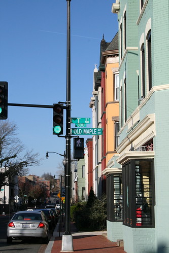
DDOT will improve T Street in early May
ANC Commissioner Brian Footer informed me that DDOT will apply a slurry seal to T Street from Second Street to Sixth Street one day from May 1 to May 6. The sealant fills cracks and slows asphalt deterioration. During the special day that DDOT applies the sealant, parking will be prohibited on T Street and driveways will be inaccessible from 8 am to 5 pm. DDOT will post notices 72 hours before the work begins.
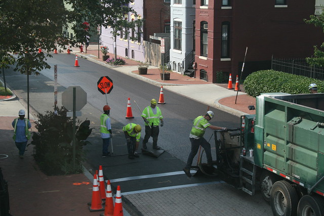
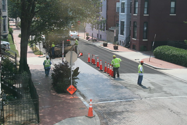
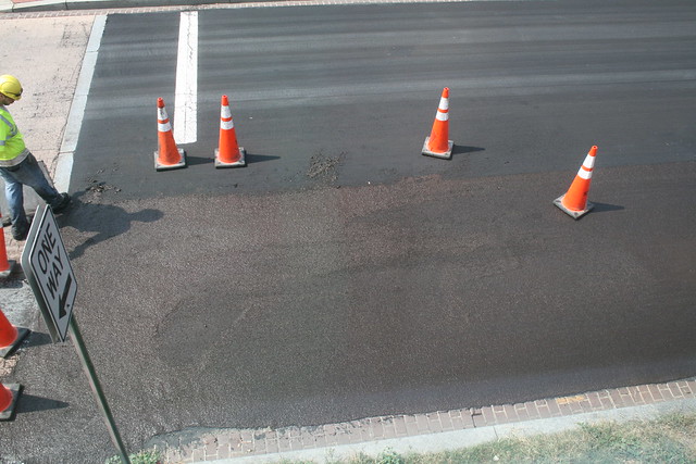
DDOT applied the same treatment to Fifth Street back in 2013. Here are some photos of the process and the results.
DDOT to plant 16 trees in LeDroit Park this fall

Fall is a good time to plant trees. DDOT has released its tree-planing map and LeDroit Park is slated to receive 16 trees. The agency only plants trees in public space, meaning the trees will be planted in the tree boxes or planting strips between the sidewalks and the curbs.
- 501 T Street
- 406 T Street
- 324 T Street
- 318 T Street
- 471 Florida Avenue
- 1934 3rd Street
- 1842 2nd Street
- Opposite 1915 2nd Street
- Opposite 1919 2nd Street
- 1948 2nd Street
- 1929 2nd Street
- 329 Rhode Island Avenue
- 455 Florida Avenue
Sweetgum (Slender Silhouette cultivar)
- 453 Florida Avenue
- Opposite 432 Oakdale Place
Cherry tree (Snow Goose cultivar)
- Southwest circumference of Anna Cooper Circle
Video: Bloomingdalers upset about recurring flooding
Channel 4 has a short segment on Tuesday night’s flooding in Bloomingdale and LeDroit Park. The Post also has a story describing the sewage-drenched nightmare that struck many residents’ basements.
DC Water, which is responsible for the water pipes and sewers, left the following note in the comments section of yesterday’s post on the flooding:
Neighbors,
We’ve received a number of phone calls, tweets and email inquiries from Bloomingdale, LeDroit and Eckington customers who faced flooding last night. We’re so sorry to hear this has happened, and want to provide some background information as well as next steps.
The sewer system under this part of the District was installed generations ago by the federal government. At the time, populations were smaller, rains were likely lighter, and people weren’t commonly living in basements. The system was not designed to handle the volume it handles today. We inherited this system and are working to upgrade it, but this is not a fast, simple or inexpensive process.
We do clean every catch basin in the District once a year, and we come through flood-prone areas to do more cleaning every time a big storm is predicted. This one was not part of any weather forecast. The volume of rain in such a short period would overwhelm many catch basins as well.
The best short-term solution is a backflow preventer, which a licensed plumber can install. The long-term solution is enlarging the capacity of the sewer system, which will come as part of our Clean Rivers Project. It is a 20-year, $2.6 billion effort to build 13 miles of tunnels, which will capture stormwater and sewage and send them to our Blue Plains Advanced Wastewater Treatment Plant. The tunnel will start at Blue Plains and is under construction now. The last segment will make its way from RFK Stadium to Gallaudet University and will relieve the historic flooding problems in Bloomingdale, Eckington and Edgewood.
More details are here: http://www.dcwater.com/workzones/projects/anacostia_river_information_sheet.cfm. Customers with questions can feel free to email us at twitter@dcwater.com or call (202) 612-3400 anytime.
DC Water
Office of External Affairs
There are two things to glean from the comments section in yesterday’s post. One is that a number of Bloomingdale residents have said that flooding occurs in their basements more than once a year. Another is that DC Water’s solution, which includes the construction of an interceptor sewer tunnel, is years away.
DC Water will address residents on Monday, July 16 at 7 pm at St. George’s Episcopal Church at 2nd and U Streets NW.
Street names changed in 1890

Two years ago we wrote about the old street names for LeDroit Park. Finding out just when the name change occurred is hard to pin down. Different sources, from address directories to newspaper articles, refer to old names and new names during the same period of time.
The mystery is closer to resolution, however, as we found what we believe to be the earliest reference to the name change:
New Names for Le Droit Park Streets.
Washington Post
July 31, 1890The names of the streets in Le Droit Park have been changed as follows: Le Droit Park avenue to Second street, Harewood avenue to Third street, Linden street to Fourth street, Larch street to Fifth street, Juniper street to Sixth street, and Maple avenue to T street.
There appears to be an error in the article as ‘Le Droit avenue’ never actually had ‘Park’ in its name.
“LE DROIT PARK. What Three Years Have Done.”
We came across this 1876 article documenting the initial improvements to the nascent LeDroit Park.
LE DROIT PARK. What Three Years Have Done.
National Republican
September 4, 1876Mr. James H. McGill, architect, has forwarded to the inspector of buildings, Mr. Thos. M. Plowman, a communication, in which he furnishes interesting information in relation to the improvements made in LeDroit Park within the last two years. He states that the different tracts of land composing the park were purchased at different times from June, 1872, to March, 1873, by Messrs. A.L. Barber & Co., and united by these gentlemen into one tract, which has been carefully surveyed and recorded. This park is in the form of an equilateral triangle, with one side resting on Boundary street [now Florida Avenue] and reaching from Seventh street eastward to Second street, and contains fifty acres. Until its subdivision by the present proprietor the eastern tract had been used for private residences and grounds, and the western portion had laid uninclosed for several years, and had been used as a public common. Improvements were soon commenced on a liberal scale; a handsome pattern of combination wood and iron fence was adopted and built all along the entire front and a board fence all along the rear, making one inclosure. All the interior fences were removed, and the lots thrown in together, affording a continuous sward. Streets were graded, graveled and guttered, brick sidewalks were put down, and gas, water and sewer mains laid.
The erection of buildings was commenced in July, 1873, since which time eight large brick residences have been erected on the north side of Maple avenue [now T Street] and two on the south side, costing from $4,000 to $12,000 each; ten houses on the north side and ten on the south side of Spruce street [now U Street], at an average cost of $3,500; two houses on the north side of Elm street, costing $3,000 each; four houses on east side, and five on the west side of Harewood avenue [now 3rd Street],costing from $4,000 to $10,000 each. A very superior stable and carriage-house has been completed for A. Langdon, esq., and another is in course of erection for A. R. Appleton, esq. Up to this date forty-one superior residences and two handsome stables have been constructed, at a cost of about $200,000. These houses are either built separately or in couples; are nearly all of brick; of varied designs, no two being alike either in size, shape or style of finish, or in the color of exterior. About $4,000 has been expended in the purchase and planting of ornamental shade trees and hedges, and about $50,000 in street improvements. About 4,500 lineal feet of streets have been graded and graveled, 9,000 feet of stone and brick gutters laid, 5,000 feet of brick pavement, 4,000 feet of sewer mains, 3,550 feet of water mains and 3,800 feet of gas mains laid. All of this expense has been by the proprietors of the property without a dollar from the District or authorities, and all the work has been done in the best and most liberal manner, under the direction of Mr. McGill. The plan contemplates the finishing of all its streets and the erection of two hundred tastefully-designed, conveniently-arranged and well-built detached and semi-detached residences, and when completed cannot fail of being a credit to all concerned. During the time stated the value of improvements constructed in other portions of the county amount to upwards of $100,000.
Census data for LeDroit Park
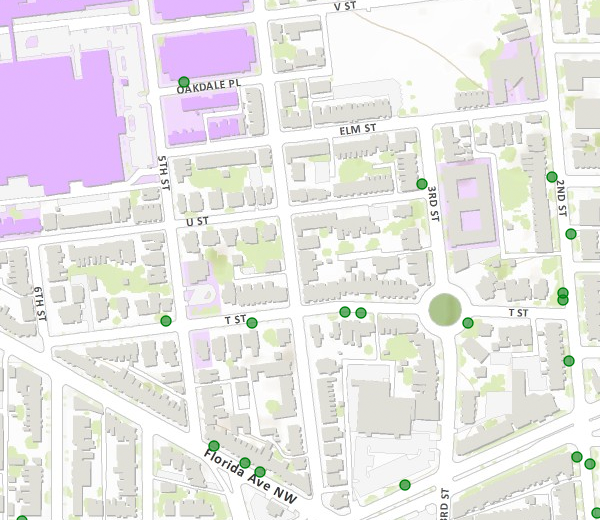
In preparation for redistricting Ward 1’s ANCs, the DC Office of Planning has released block-by-block demographic data for the District. We have combined the data for the blocks that comprise LeDroit Park to create a LeDroit Park census.
Analyzing U.S. Census data for LeDroit Park proves difficult because the of the way census tracts are drawn. Our census tract, 34, combines LeDroit Park and Howard University. Dorms on the northern end of the campus, far away from LeDroit Park, account for 717 of the tract’s 4,347 residents, thus skewing tract data. Furthermore, the tract also inclues several blocks bounded by Rhode Island Avenue NW, Florida Avenue NW, and 2nd Street NW.
Fortunately, the Census Bureau provides data for each block, allowing us to combine the statistics for those blocks in LeDroit Park, while excluding the Howard University campus. In the map below, we have outlined the tract in blue and shaded the blocks for LeDroit Park in red.
View LeDroit Park Census in a larger map
Though LeDroit Park started out as an exclusively white suburban neighborhood, by 1910 the neighborhood was almost entirely black. Today, 100 years later, the neighborhood is 70% black and is continuing to diversify.

However, when looking at the numbers on a block-by-block basis, you see that the neighborhood demography, must like that of the District itself, is unevenly distributed.
The block bounded by 5th Street, T Street, 6th Street, and U Street is 53% white, the highest in the neighborhood. Likewise, the block containing the Kelly Miller public housing is 91% black, the highest percentage in the neighborhood. The block containing the arch and the Florida Avenue Baptist Church comes closest to black-white equilibrium at 44% and 49% for each group respectively.

When looking at total population numbers for each block, you see that the two most populous blocks contain Howard University dorms. The block bounded by 2nd Street, T Street, 3rd Street, and Elm Street has 382 residents and contains Slowe Hall, which houses 299 students.
The second most populous block contains the new park. However, it also contains Carver Hall, which itself houses 173 students. Certainly these blocks are big, but the fact that their population numbers are off the chart has more to do with student dorms than with any inherent difference in housing density.

Finally, when we look at housing vacancy, we see that the block bounded by 5th Street, T Street, 6th Street and U Street has 38% of its housing units vacant. We’re not sure what’s causing this number, but we suspect that the apartment building at 5th and U Streets NW boosted the vacancy rate. The building has since been finished and is fully rented.
The block with the second-highest rate of vacancy contains the now-renovated Ledroit Place condo building at 1907 3rd Street NW.

It would be interesting too look at other data, including household income, car ownership, and age distribution for the neighborhood. However, the Office of Planning’s spreadsheet only covered population numbers, racial distribution, and housing unit numbers, so those are the metrics we graphed.
LeDroit Park Market Robbed
 Simon’s store, the LeDroit Park Market at Fourth and T Streets NW was robbed earlier this afternoon. The suspect is described as a black man, 5′ 6″ to 5′ 7″, bearded, and wearing a green shirt, white sunglasses, a dark colored hat, blue jeans with black shoes. The neighborhood-funded surveillance camera placed on Simon’s store may have caught a glimpse of the suspect.
When Simon opened his second business, Cookie’s Corner at the corner of Second and Elm Streets NW, some decried the presence of bullet-proof glass at the counter. Does this latest robbery vindicate that decision?
Cookie’s Corner with Pizza
If you haven’t heard, Cookie’s Corner at the Second and Elm Streets NW is now open for business. It’s somewhat like the LeDroit Park Market, which is owned by the same person, but Cookie’s Corner will serve pizza in addition to sandwiches.
We, like others, are a tad disappointed with the inclusion of a curtain of bulletproof glass at the counter. Then again, it’s easy to issue that criticism if you’re not the person who has to staff the counter.
We paid a visit on Tuesday and were informed that food service begins this weekend.
LeDroit Park in 1921
We were paging through the excellent online map collection of the Library of Congress and downloaded the 1921 Baist Real Estate Atlas of Washington, DC. This meticulous city atlas marked all the water mains, sewers, streets, squares, lots, and buildings. Buildings were shaded to indicate their construction materials (red for brick, yellow for wood). Subdivision names as well as the names of certain proprietors made their ways into the Baist maps, too.
We’re actually studying this atlas to do some research for an upcoming post on the zoning code, but for your convenience we’ve stitched together the three pages of the atlas covering LeDroit Park and Bloomingdale and published it as a single PDF document. Here are a few highlights.
The 400 block of U Street, famous for its houses designed by Washington architect James McGill, reveals that the lots 12, 13, and 14 in square 3081 are wood houses, while all the other McGill houses on the block are brick.

Here’s the original Gage School, now a condo building, on Second Street. Notice the Moore property, which predates the establishment of LeDroit Park, extending all the way south to Florida Avenue.

The current site of the United Planning Organization on Rhode Island Avenue was the estate of engraver David McClelland. As we wrote before, the U.S. War Department confiscated Mr. McClelland’s map of the District at the outbreak of the Civil War. The Elks later purchased the McClelland estate and eventually sold it and moved into their current building on Third Street (marked as Harewood Avenue below).

In the 1970s, the city razed all the area shaded in green below to make way for Gage-Eckington Elementary School, which was itself razed just last year after years of declining enrollment.

Heritage Trail for LeDroit Park and Bloomingdale

You’ve seen them around DC. Those tall signs with historic photos and narratives explaining what happened in that neighborhood 70 or 200 years ago. Several neighborhoods in DC have heritage trails, courtesy of Cultural Tourism DC.
We in LeDroit Park and Bloomingdale are on our way to getting our very own heritage trail, but the LeDroit Park-Bloomingdale Heritage Trail Working Group needs your help.
The Working Group will meet on Wednesday, May 12 at 7 pm at St. George’s Episcopal Church (Second & U Streets) to collect stories, old photos, and to plan how to interview our neighborhoods’ long-time residents.
Do you have an old photo or an old story to tell or are you interested in local history? LeDroit Park has hosted many notable residents from Civil War generals, to Duke Ellington, to Walter Washington, and even Jesse Jackson!
Come join us Wednesday night and learn how you can help.
Wednesday, May 12
7 pm
St. George’s Episcopal Church
Second & U Streets NW


Recent Comments