
Census data for LeDroit Park
In preparation for redistricting Ward 1’s ANCs, the DC Office of Planning has released block-by-block demographic data for the District. We have combined the data for the blocks that comprise LeDroit Park to create a LeDroit Park census.
Analyzing U.S. Census data for LeDroit Park proves difficult because the of the way census tracts are drawn. Our census tract, 34, combines LeDroit Park and Howard University. Dorms on the northern end of the campus, far away from LeDroit Park, account for 717 of the tract’s 4,347 residents, thus skewing tract data. Furthermore, the tract also inclues several blocks bounded by Rhode Island Avenue NW, Florida Avenue NW, and 2nd Street NW.
Fortunately, the Census Bureau provides data for each block, allowing us to combine the statistics for those blocks in LeDroit Park, while excluding the Howard University campus. In the map below, we have outlined the tract in blue and shaded the blocks for LeDroit Park in red.
View LeDroit Park Census in a larger map
Though LeDroit Park started out as an exclusively white suburban neighborhood, by 1910 the neighborhood was almost entirely black. Today, 100 years later, the neighborhood is 70% black and is continuing to diversify.

However, when looking at the numbers on a block-by-block basis, you see that the neighborhood demography, must like that of the District itself, is unevenly distributed.
The block bounded by 5th Street, T Street, 6th Street, and U Street is 53% white, the highest in the neighborhood. Likewise, the block containing the Kelly Miller public housing is 91% black, the highest percentage in the neighborhood. The block containing the arch and the Florida Avenue Baptist Church comes closest to black-white equilibrium at 44% and 49% for each group respectively.

When looking at total population numbers for each block, you see that the two most populous blocks contain Howard University dorms. The block bounded by 2nd Street, T Street, 3rd Street, and Elm Street has 382 residents and contains Slowe Hall, which houses 299 students.
The second most populous block contains the new park. However, it also contains Carver Hall, which itself houses 173 students. Certainly these blocks are big, but the fact that their population numbers are off the chart has more to do with student dorms than with any inherent difference in housing density.

Finally, when we look at housing vacancy, we see that the block bounded by 5th Street, T Street, 6th Street and U Street has 38% of its housing units vacant. We’re not sure what’s causing this number, but we suspect that the apartment building at 5th and U Streets NW boosted the vacancy rate. The building has since been finished and is fully rented.
The block with the second-highest rate of vacancy contains the now-renovated Ledroit Place condo building at 1907 3rd Street NW.

It would be interesting too look at other data, including household income, car ownership, and age distribution for the neighborhood. However, the Office of Planning’s spreadsheet only covered population numbers, racial distribution, and housing unit numbers, so those are the metrics we graphed.
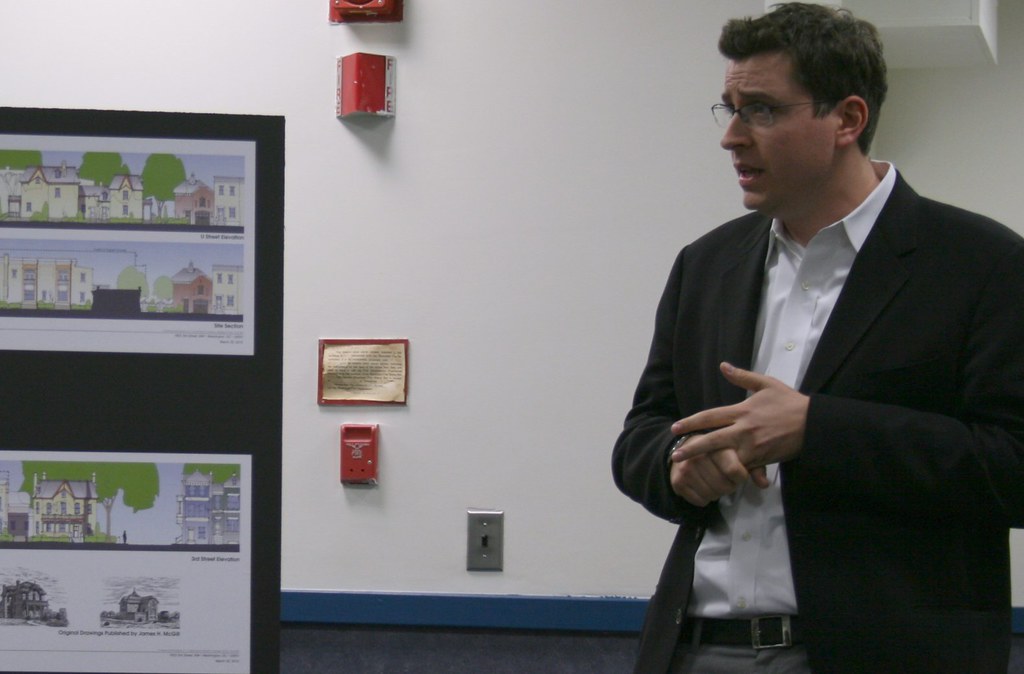
Three Projects Break Ground This Week
We’re back from our half-month vacation and LeDroit Park and Shaw are about to see some construction action starting today.
Wednesday, September 1 – 10:30 am
Just when we thought construction on the park on the site of the old Gage-Eckington School would begin, along came the parks scandal last October. Then in March, Harry Thomas Jr. (D – Ward 5) tried to prevent the mayor from appropriating money to the park project; he then reversed himself after an avalanche of constituent criticism. The new contract was ready to go until Councilmember Marion Barry (D – Ward 8) put a hold on the contract in late July. Mr. Barry’s delay procedure just expired and the mayor’s office will host a groundbreaking ceremony today at 10:30 am at Third and Elm Streets.
3:00 pm
Over in Shaw, the two block site currently occupied by Giant and a crumbling old market façade is about to start its journey to become a vibrant mixed-use development. Join the Del. Eleanor Holmes Norton (D), Mayor Adrian Fenty (D), Council Chairman Vincent Gray (D), Councilmember Jack Evans (D – Ward 2) and Councilmember Kwame Brown (D – at large) for the groundbreaking.
Thursday, September 2 – 10:45 am
After years of planning and promises, construction on the Howard Theatre begins in earnest. Join the developer, ANC Commissioner Myla Moss, and other notables for the official groundbreaking.
We’re relieved to see these long-promised projects finally moving forward to construction.
How LeDroit Park Came to be Added to the City
The following is a Washington Times article from 1903. The article explains some of the early history of the neighborhood and even includes three photos, the first of which was misidentified as Fifth Street, though we have actually matched it up with Second Street. We have included a few links to related information.

Second Street opposite the Anna J. Cooper House.
HOW LE DROIT PARK CAME TO BE ADDED TO THE CITY
Washington Times
Sunday, May 31, 1903For Many Years the Section of Washington Known by That Name Had Practically Its Separate Government and Had All the Characteristics of a Country Town, Although Plainly Within the Boundary Limits. * * *
In that portion of Florida Avenue between Seventh Street and Eighth Streets northwest where the street cars of the Seventh Street line and the Ninth Street line pass over the same tracks, thousands of passengers are carried every day, and probably but a few if any realize the fact that they are passing over a road older than the organization of the city, a road that dates back to the Revolutionary period— the Bladensburg Road, which connected Georgetown with Bladensburg before the location of the National Capital was determined.
The Map on the Wall.
If the people passing this point will note the little frame building occupied by a florist, 713 Florida Avenue northwest, they will observe that in front of these premises and fastened to the blacksmith shop adjoining is a goodly sized signboard on which is painted an old map of this section and showing the intersection of the old Blandensburg Road and Boundary Street, now known as Florida Avenue. From this map it is seen that Seventh Street Road [now Georgia Avenue] intersects Boundary Street and the old Bladensburg Road at a point about 100 feet east of where the two roads join at an acute angle, and glancing along the lines of Boundary Street and the north lines of some buildings which have been erected in this angle we easily see the direction of the Bladensburg Road and discover that the small building 713 Florida Avenue northwest marks the spot where the Bladensburg Road deflected from Boundary Street and bore off in a northeasterly direction toward Bladensburg.
Once Part of Jamaica Vacancy.
The map referred to is said to be a portion of [the estate named] Jamaica and and Smith’s Vacancy, but if we examine the plats in the office of the Surveyor of the District we will hardly find on file any plats of those sections, but may learn that Le Droit Park was once part of Jamaica and Smith’s Vacancy and possibly a portion of [the estate named] Port Royal. Prior to the cession of the territory now included in the District from Maryland the land known as Jamaica was owned by one Philip R. Fendall, of Virginia. He conveyed this tract of 494 acres on the 12th day of January, 1792, to Samuel Blodgett, jr., of Massachusetts, and from this point the title of the land can be traced down to the present time.
The names attached to the different vacancies establish the names of the various owners of lands adjoining Bladensburg Road at the time it was abandoned as a thoroughfare and taken up as a portion of the farms in that section, and the presence of this old road accounts for some of the peculiar lines in some of the northern boundaries of some of the lots in Le Droit Park. This road crossed Second Street at a point north of Elm Street here. The old plats show Moore’s Vacancy. The road finally joined the present road to Bladensburg at a point where the sixth milestone of the norther line of the District was located.
It is probable that this peculiarly natural boundary of some of the lands which afterward became Le Droit Park may have had something to do with the strange lines which are found in the streets of that suburb, although it was not the intention at the time that Le Droit Park was subdivided to have the streets conform with the city streets.
Site of Campbell Hospital.
During the civil war the territory now contained in Le Droit Park was used as the site of Campbell General Hospital, one of the important hospitals near Washington. The hospital comprised some seventeen separate wooden buildings, erected in the form of a hollow square, with the central portion divided into irregular spaces by buildings cutting across the inclosure and connecting the outside buildings.
The larger dimension of this hospital was fro north to south, and extended from Boundary Street, now known as Florida Avenue, on the south, to the land occupied for many years as a baseball park, situated south of Freedman’s Hospital, and designated on some of the old maps as Levi Park. From east to west the hospital covered the ground from Seventh Street to what is now known as Fifth Street in Le Droit Park, and it is possible that a portion of the space between Fifth Street and Fourth Street was also included in the hospital inclosure.

The McClelland Residence.
At this time there were only two dwellings in the tract known afterward as Le Droit Park— the McClelland and Gilman homestands. Each included about ten acres of land used for grazing and garden purposes. The McClelland property and the Gilman property were divided by a row of large oak trees which were situated about fifty feet apart and continued from Florida Avenue, then Boundary Street, to the northern line of the park.
[See the following 1861 map, a map we extolled several months ago:

]
To the east of the Gilman tract was a narrow strip of land known as the Prather tract. East of this was Moore’s Lane, now Second Street, and still to the east was the tracts of the Moores, George and David, covering the territory as far east as the present location of Lincoln Avenue [now Lincoln Road], on which was located Harewood Hospital, another hospital of considerable note during the civil war.
T.R. Senior, who was commissary at Campbell Hospital, returned to the city some twelve years after the war closed and purchased a residence at the corner of Elm and Second Streets, where he now resides. Members of the family of David McClelland now occupy the old homestead on Second Street.
Following the close of the war it became necessary to provide for such of the freedmen as were in need of assistance. Campbell General Hospital was occupied by the freedmen until August 16, 1869, when the patients were transferred to the new Freedman’s Hospital, which has been erected in connection with Howard University.
The property upon which Freedman’s Hospital stands consisted of a tract of 150 acres and was purchased from John A. Smith. In April, 1867, Howardtown was laid out and soon after some 500 lots were sold, and at this time it seems that the idea was conveyed that streets would be opened to the south through the Miller tract. In April, 1870, the Howard University purchased the Miller tract, and laid out streets to connect the streets of Howardtown with the city streets, and a little later built four houses on the line of what is now known as Fourth Street and in 1872 subdivided the Miller tract, but for some reason the plat was not recorded.
In 1873 the Miller tract was sold by Howard University to A[ndrew] Langdon, and a short time afterward A[mzi] L[orenzo] Barber, formerly secretary of Howard University, became associated with Langdon and hs partner, and by arrangements with D[avid] McClelland, all of the three tracts known as the Miller tract, the McClelland tract, and the Gilman tract were united and subdivided, and in June, 1873, a subdivision known as Le Droit Park was placed on record in the surveyor’s office. A subsequent plat was filed some eighteen months later, in which the proprietors of the subdivision declared it to be their purpose and intention to retain and control the ownership of all the streets platted, and the right to inclose the whole or any portion of the tracts or tract included in the subdivision and to locate and control all entrances and gates to the same.

During the autumn of 1876 A. L. Barber & Co. commenced the erection of fences across the north line of Le Droit Park, and from this time until August, 1891, fences were maintained along the northern line of the park. From 1886 to 1891 frequent fence wars were in operation. The fence across what is now Fourth Street would be removed by one party, and the opposing party would secure an injunction and restore it. This mode of procedure was repeated at various times until in 1901 a compromise verdict was agreed upon by the two factions and the fence was removed, Fourth Street was improved north of the park, and the streets of the park passed into the control of the city after a period of some eighteen years of private ownership.
The organization of Le Droit Park, under the limitations of the plat filed in 1873, was a peculiar experiment, that of the founding of an independent suburb adjoining the city. the southern line of the park was inclosed with a handsome combination iron and wood fence, some of which may now be found on the southern line of the McClelland property. Buildings were erected with plenty of room around them, and during the period from 1873 to 1885 the larger part of the buildings were planned and erected by James H. McGill. Double houses were quite common, but it was not until 1888 that such a thing as a row of houses were known in the park.
Before control of the streets was surrendered to the city the conditions existing in the park resembled closely those found in small country towns. Many of the inhabitants owned cows, which were pastured upon the vacant lots; the women “went a-neighboring,” and the social life savored strongly of a village, and yet it was near the city. The express and telegraph messengers, however, always collected of residents an extra fee for the reason that they lived out of the city.
With the opening of the streets and the introduction of street cars the park soon lost its former characteristics and became part of the city with all of its advantages and disadvantages. The opening of Rhode Island Avenue [from Florida Avenue eastward] spoiled in a measure the former beauty of the McClelland and Gilman homesteads, although there is still much more ground remaining in both of these old tracts that many people would care to own. The opening of Fifth Street will, to some extent, divide the traffic which now finds a way through Fourth Street. Sixth Street ends at Spruce Street [now U Street], and further progress seems barred by the residence, 601 Spruce Street, and there seems no immediate chance of the extension of Third Street above its present limit [at V Street??], where progress is barred by a high fence decorated with the advertisement of a prominent firm.
Former Familiar Street Names.
The old names of the streets of the park, such as Harewood Avenue [now Third Street], Maple Avenue [now U Street], Moore’s Lane [later Le Droit Avenue, then Second Street], Linden Street [now Fourth Street], Larch Street [now Fifth Street], Juniper Street [now Sixth Street], and Bohrer Street [still extant], are nearly forgotten, and have passed away with the fence and its period. The names of the city streets have taken their places, and with the growth of the population the country life and country scenes have given way to those of the city.
Civic Associations Past

Gen. William Birney lived in the mansard-roofed duplex on Anna J. Cooper Circle.
The LeDroit Park Civic Association meets tonight, following a long tradition of meetings to improve the neighborhood. Take a look at this newspaper article from the National Republican published on March 26, 1881:
Improvements Proposed by the Property Owners.
In response to a call issued, there was a very full attendance of the members of Le Droit Park Property Owners’ Association last night in the park. The meeting was called to order by Mr. W. Scott Smith1, the president of the association, who proceeded to state what had been done since the last meeting to promote the interests of the park and the large number of residents living therein. The first business before the association was the election of officers for the ensuing year. On motion of General W. W. Birney2, Mr. W Scott Smith was unanimously re-elected president of the association, Colonel O. H. Irish3 was nominated and elected vice-president; James H. McGill4, secretary; J. J. Albright5, treasurer, and E. B. Barnum6 the additional member of the executive committee. The president said he had recently had an interview with the District Commissioners, and the lighting of two additional gas lamps in the park had been ordered. He had seen the Major and Superintendent of Police about giving the park better police protection, and had received assurances that the matter should receive prompt attention, and an officer detailed specially for night duty in the park.
General Birney submitted a motion, which was adopted, that a vote of thanks be extended to the president of the association for his active efforts during the past year in behalf of the park.
The question of opening a new street on the east side of the Park, running from Boundary street [now Florida Avenue] through to the Soldiers’ Home, then came up, and gave rise to considerable discussion, all concurring in the opinion that such a street was needed. A resolution was the offered and adopted that the members of the association will co-operate heartily with the District Commissioners in securing the opening of such a street and road, and instructing the executive committee to take steps to make effective such co-operation. Attention was directed to the fact that all the houses and a large amount of property in the Park were greatly exposed and jeopardized in case of a fire by the action of the water department in shutting off the pressure of water between the hours of midnight and five o’clock a.m., and thus practically preventing the flow of water in the park. The executive committee were directed to look in the matter and endeavor to have it remedied as soon as possible. The need of a fire-engine in the northern section of the city was regarded as very pressing. After discussing various other matters and directing that rules be prepared for the government and guidance of the special day-policemen, the meeting adjourned.
References
- Private secretary to the Secretary of the Interior; resident of 525 T Street NW. Halford, A. J. Official Congressional Directory. Washington: GPO, 1900.
- Civil War general; resident of 1901 Third Street NW. Read more at Wikipedia.
- Head of the Bureau of Engraving and Printing among other accomplishments; resident of 1907 Third Street NW. National Republican. Washington, Jan. 13, 1879 and Richardson, F. A. Congressional Directory. Washington: GPO, 1880.
- Architect of LeDroit Park.
- Wealthy coal distributor. Cutter, Library Journal. Vol. 17. New York: ALA, 1892.
- Tailor and clothier, E. B. Barnum & Co.; resident of 1883 Third Street NW. Boyd, William Henry. Boyd’s Directory of the District of Columbia. Washington: Boyd, 1887.
LeDroit Park in 1921
We were paging through the excellent online map collection of the Library of Congress and downloaded the 1921 Baist Real Estate Atlas of Washington, DC. This meticulous city atlas marked all the water mains, sewers, streets, squares, lots, and buildings. Buildings were shaded to indicate their construction materials (red for brick, yellow for wood). Subdivision names as well as the names of certain proprietors made their ways into the Baist maps, too.
We’re actually studying this atlas to do some research for an upcoming post on the zoning code, but for your convenience we’ve stitched together the three pages of the atlas covering LeDroit Park and Bloomingdale and published it as a single PDF document. Here are a few highlights.
The 400 block of U Street, famous for its houses designed by Washington architect James McGill, reveals that the lots 12, 13, and 14 in square 3081 are wood houses, while all the other McGill houses on the block are brick.

Here’s the original Gage School, now a condo building, on Second Street. Notice the Moore property, which predates the establishment of LeDroit Park, extending all the way south to Florida Avenue.

The current site of the United Planning Organization on Rhode Island Avenue was the estate of engraver David McClelland. As we wrote before, the U.S. War Department confiscated Mr. McClelland’s map of the District at the outbreak of the Civil War. The Elks later purchased the McClelland estate and eventually sold it and moved into their current building on Third Street (marked as Harewood Avenue below).

In the 1970s, the city razed all the area shaded in green below to make way for Gage-Eckington Elementary School, which was itself razed just last year after years of declining enrollment.

Where Have All the Craftsmen Gone?
DC development blog DCmud interviewed Grant Epstein, who recently withdrew his proposal for 1922 Third Street NW. Mr. Epstein’s development company focuses primarily on adaptive reuse of historic properties.
One part of the interview caught our eye, as Mr. Epstein confirms what we have long suspected: ornate houses are difficult to build today because it’s harder to find skilled craftsmen to built custom ornaments:
It’s amazing the amount of craftsmanship that went into these houses on [Capitol Hill]. Detail that it’s very hard to replicate today. So the old townhouses, they inspire me. We’ve lost a lot in our new buildings, in the construction of them. It primarily has to do with the number of pieces that go into a house. There aren’t many craftsmen that know how to do the details.
….
[T]he people don’t exist anymore… the trades don’t exist. For instance, iron staircases. Two or three guys in the area do iron staircases the right way. Two or three guys! Back in the early 1900s there were forty! It’s a big difference. At M Street we found the iron treads from an old turn of the century house and recast the iron posts in order to use the same style that was supposed to be there, but was missing. There were only a couple of guys who knew how to do that.
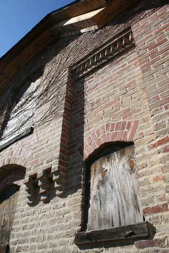
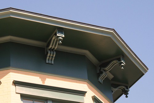
While walking around LeDroit Park, we frequently notice detailed architectural ornaments that never adorn contemporary buildings. How many bricklayers today have the experience and skill to lay bricks as was done at the Mary Church Terrell house when it was built?
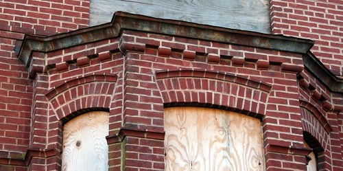
And how many bricklayers have the experience to construct a façade like this one on the McGill carriagehouse at 1922 Third Street?
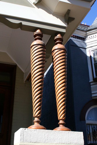
The owners of this house on Third Street told me how impossible it was to find somebody to replicate these columns:
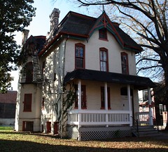
Rarely will you find anything like the gingerbread on the Anna J. Cooper house:
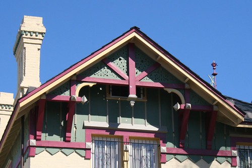
Brackets like these require a good amount of craftsmanship to carve and paint:
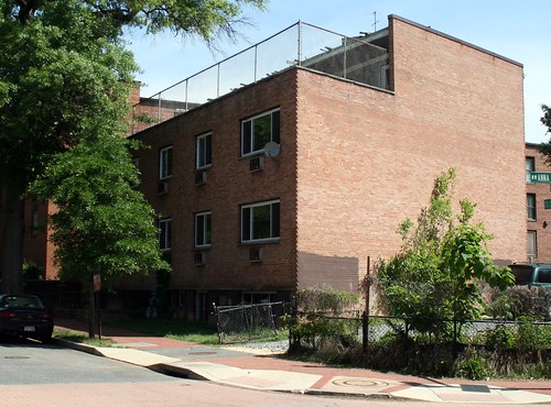
Contrast these houses with the vacant apartment house at 1907 Third Street NW:
Coffeehouse Coming to Florida Avenue
At tomorrow’s monthly meeting of ANC1B, representatives for a fledgling coffeehouse/lounge, The Independent (715 Florida Avenue NW), will petition for a Class C liquor license. The Independent seeks to serve beer, wine, and liquor to a maximum of 235 people (199 seats) on the first floor and a maximum of 90 people (75 seats) in the summer garden. They propose these hours:
| Sun | Mon | Tue | Wed | Thu | Fri | Sat | |
|---|---|---|---|---|---|---|---|
| Open | 7am | ||||||
| alc. served | 10am | 8am | |||||
| last call & close | 2am | 3am | |||||
Entertainment will run 6pm – 2am (Sun. – Thurs.) and 6pm – 3 am (Fri. and Sat.).
Up at 2632 Georgia Avenue, GII Restaurant & Lounge plans to host acoustic jazz bands, karaoke, open mike nights, and DJs to a maximum of 102 people (86 seats). They propose the following business hours: 6 am-2:30 am (Mon. – Wed.) and 6 am-3 am (Thurs. – Sun.). The propose serving alcohol 10 am-2 am (Sun.), 8 am-2 am (Mon. – Thurs.) and 8 am-3 am (Fri. and Sat.). Entertainment will be 6 pm-2:30 am (Mon. – Wed.) and 6 pm – 3 am (Thur. – Sun.).
Here in LeDroit Park, the Elks Lodge at 1844 Third St seeks to renew its license but not without controversy. In April 2008 the lodge was the site of a triple-stabbing and just a few months ago, the lodge was delinquent in paying license fines.
In addition to the lodge, the following restaurants seek to renew their licenses:
- Alero Lounge, 1301 U Street, Class C
- Crème Café & Lounge, 1322 U Street, Class C
- Little Ethiopia Restaurant, 1924 Ninth Street, Class C
- Portico, 1914 Ninth Street, Class C
- Mesobe Restaurant and Delimarket, 1853 Seventh Street, Class C
As usual, the ANC meeting will be held tomorrow (Thursday) at 7 pm on the second floor of the Reeves Building at Fourteenth and U Streets.
Side Yards and Side Views

1922 Third Street concept, east face on Third Street
At Tuesday’s LeDroit Park Civic Association meeting, the Mr. Grant Epstein presented his proposal for 1922 Third Street, the property we have written about before. There appeared to be a mix of opinions at the meeting ranging from support to strong opposition. The most contentious part is by far the proposed townhouse (middle of the picture above). We’ve outlined most of the main objections before (massing, parking, use) so we won’t rehash them here.
Mr. Epstein estimated the renovation of the main house alone to cost $1.5 million and that the entire project would cost $5-6 million. Each unit would average around 800 square feet with the additional space devoted to common areas (halls, stairs, etc.).
There was one interesting matter of zoning that needs clarification. It is currently unknown if the north wall of the existing adjacent townhouse (left, picture above) sits entirely on its own property or if it is a typical party wall with half of the wall on one property and half on the other.
If it is indeed entirely on its own property (abutting, but not crossing, the property line), Mr. Epstein stated that his proposed townhouse would rest on its own wall just up to, and entirely within, his property line.* If this the case, one neighbor told us that such an arrangement might violate the R-4 zone’s side yard requirement of an eight-foot setback from the side property line. Are any zoning experts able to clarify this?
The zoning code appears unclear to us. 11 DC Code § 405.3 states
In R-2, R-3, R-4, and R-5 Districts, when a one-family dwelling, flat, or multiple dwelling is erected that does not share a common division wall with an existing building … it shall have a side yard on each resulting free-standing side.
If the existing side wall of the adjacent property is indeed entirely within its own property (even if abutting the property line), is it considered a “common division wall”? If it can’t be considered such a wall, then this section requires a side yard for the proposed townhouse. But later on down, § 405.6 states
Except as provided in §§ 405.1 and 405.2 [that both relate to single-family dwellings], a side yard shall not be required in an … R-4 … District. However, if the yard is provided, it shall be at lease three inches (3 in.) wide per foot of height of the building, but not less than eight feet (8 ft.) wide.
The determining factor appears to be whether the side yard requirement actually hinges on the placement of the neighbor’s side wall— that is, abutting the property line or straddling the property line.
Anyway, one resident also thought it would be useful to color in the side view of the proposed townhouse. We have replicated his method below (the side of the townhouse is in red, the rear addition in green)

View from U Street. The proposed townhouse in red and the rear addition in green.
Such extensive construction and renovation in a historic district means that the design and permitting process provide many opportunities for public input. Even if you missed the first three presentations (grayed-out below) you have at least two more public opportunities to comment:
- ANC1B Meeting – Thursday, March 7
- ANC1B Design Committee Meeting – Tuesday, March 16
- LeDroit Park Civic Association – Tuesday, March 23
- ANC1B Meeting – Thursday, April 1 at 7 pm on the second floor of the Reeves Building, 14th & U Streets.
- Historic Preservation Review Board (tentative) – Thursday, April 22 at 10 am at One Judiciary Square (441 Fourth Street NW), Room 220 South.
What do you think? Do you like the plan, oppose the plan, or does your opinion lie somewhere in between? Leave your comments below; I’m quite sure the developer reads this blog and will be interested to know what you think.
* The developer has not actually bought 1922 Third Street yet. He has a contingent contract to buy it.
More Details on 1922 Third Street
At Thursday’s monthly meeting of ANC1B, Grant Epstein, president of Capitol Hill-based Community Three Development, presented his proposal for 1922 Third Street, a project we wrote about a few days ago.
His proposal calls for renovating the main house (top right) and carriage house (bottom right) and for constructing a connecting section as well as a new townhouse. Because the lot is 13,600 square feet, the R-4 zoning code permits multi-unit apartments with the maximum number of units set to the lot area divided by 900. Although Mr. Epstein proposes 14 units, the zoning code actually permits 15 units by right (13,600 / 900 = 15.1).
Since LeDroit Park is a historic district, most exterior renovations and all new construction within the district’s boundaries must undergo a review process that begins with the Historic Preservation Office (HPO), which is tasked with ensuring that such projects preserve, match, or enhance the historic character of the neighborhood. Ay, there’s the rub: historic character means different things to different people.
Even if the standards for historic preservation are themselves nebulous, the process itself is designed with a good deal of transparency. Mr. Epstein’s proposal must be approved by the city’s Historic Preservation Review Board, which holds a public hearing during which the applicant presents the plan, the HPO staff present their report, and ANC representatives, community groups, and interested citizens may testify either way on the plan. The board then approves the project, rejects it, or approves it with conditions.
Mr. Epstein stated that he has consulted with HPO staff to refine his proposal to satisfy their interpretation of historic preservation suitable for LeDroit Park. We say “their interpretation” not to be snarky, but rather to remind readers that what constitutes historically appropriate is often a subjective matter of taste and judgment. The past, much like the present, is a collection of different stories, styles, and attitudes. Sometimes there is no one right answer in preservation matters, especially in a neighborhood featuring the Victorian, Queen Anne, Italianate, Second Empire, Gothic Revival, and Spanish Colonial styles among others.
At the ANC meeting and in discussions with residents, we have gleaned the following concerns in addition to many thumbs-up.
1922 Third Street concept, east face on Third Street
Height
Commissioner Myla Moss (ANC1B01 – LeDroit Park), expressed concern that the proposed townhouse (the middle building in the drawing above) was too tall for the row of neighboring townhouses. Mr. Epstein replied that the added height of the building was in fact the suggestion of HPO staff. Their reasoning, Mr. Espstein stated, is that in Washington, end-unit rowhouses have typically been more prominent than the intervening houses. The prominence was typically marked by extra size, extra height, and extra ornamentation. The added height, Mr. Epstein asserted, is in keeping with an end-unit rowhouse. He also noted that many other buildings on the street are taller than what he proposes.

1922 Third Street concept, north face on U Street
Parking
Others expressed concern that the addition of 14 homes on the site would overwhelm the adjacent streets with parked cars since the proposal includes only four parking spaces (one in the carriage house and three in the new adjacent structure pictured above). Mr. Epstein replied that he originally proposed five spaces, but HPO staff suggested that he reduce the number to four so as not to overwhelm a historic structure with an abundance of car parking. Since fewer people owned cars back then, historic architecture is less car-obsessed than today’s buildings— notice how few driveways and garages you’ll find in Georgetown compared to any neighborhood built in the last 60 years.
Mr. Epstein stated that a way to discourage new residents from owning cars was to reduce the amount of available on-site parking. There was at least one skeptical guffaw from the audience, though the reality will likely depend on a variety of factors. Mr. Epstein suspects the project will attract residents more inclined to live car-less.
Commissioner Thomas Smith (ANC1B09), an architect, asked what features besides reduced on-site parking Mr. Epstein would incorporate to discourage car ownership. Mr. Epstein had none, but was open to considering bike storage and car-sharing.
Use
One resident expressed concern that converting what was once a single-family house (before it became a rooming house in the 1970s) into a multi-unit condo building could itself contradict LeDroit Park’s original intent as a country suburb of single-family homes.
Other Details
In response to our question, Mr. Epstein stated that he intended to follow the city’s new inclusionary zoning regulations, which would translate to one of the fourteen units being set aside for a buyer of modest means.
We also noted to Mr. Epstein that though the rowhouse is intended to be an ornamental end-unit— an “exclamation mark” at the end of a row, as he put it— the side of the townhouse, as illustrated in his drawing above, lacks the adornment typical of end-unit rowhouses. Mr. Epstein stated that there was some debate on the issue, still unresolved, as to whether the side of the rowhouse should fully serve as the “exclamation mark” or serve as “canvas” upon which to view the original 1880s structure.
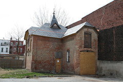
Mr. Epstein also explained the dire condition of the house and carriage house. The main house was entirely gutted of its original interior and years of neglect have left a damaged foundation and ample mold. The carriage house (pictured at the top of this post) is itself crumbling from the weight of the recent replacement roof. Both structures require a significant investment of money to rehabilitate. The investment of money required as well as the uncertain historic review process both make the project something that Mr. Epstein says few developers would touch.
* * *
As a tactical measure to postpone the HPRB’s review of the proposal, the ANC voted to oppose the concept until the developer could present his proposal to the LeDroit Park Civic Association and the ANC’s newly formed design review committee. The ANC will likely address the matter again at the April meeting.
If you’re interested in learning more about the proposal or expressing your concerns or support, feel free to attend any of the following meetings:
- ANC1B Design Committee – Tuesday, March 16 at 6:30 pm at 733 Euclid Street NW.
- LeDroit Park Civic Association – Tuesday, March 23 at 7 pm at the Florida Avenue Baptist Church, 6th & Bohrer Streets.
- ANC1B – Thursday, April 1 at 7 pm on the second floor of the Reeves Building, 14th & U Streets.
Activity at 1922 Third Street
The house at 1922 Third Street (Third and U Streets) is one of the LeDroit Park’s gems and is about to receive some much needed attention. At Thursday’s ANC1B meeting, Community Three Development will submit this concept to renovate the main house, to renovate the carriage house, and to build a new townhouse at the southern edge of the property.
The developer recently finished the swanky M Street Flats located in Mount Vernon Triangle area. The group also completed The Nine on the 1300 block of Ninth Street, backing up to the historic Naylor Court. If these forerunners are any indication, 1922 Third Street may receive a high-end renovation.
The developer’s design, in his words,
creates an addition to the existing main building that is smaller in scale and secondary to the main building, allowing the main structure to continue to read as the dominant form on the site. This addition terminates in a “carriage house court,” designed to celebrate the existing carriage house, while maintaining the historic structure’s existing view corridor from U Street. A new unsubdivided townhouse lot and structure is created to terminate the row of townhouses directly to the south of the site. The result of these interventions preserves and enhances the character and urban form associated with the main structure and corresponding carriage house.
Though Community Three will need the approval of the city’s Historic Preservation Review Board for the overall project, they are not seek zoning variances.
The proposal calls for 14,000 gross square feet of space and features 14 residential units and four garage spaces— a mixture that the developer claims zoning ordinances permit.
Here are some drawings and diagrams from the concept. Note that the developer proposes to add a new rowhouse on the south side of the property (middle-left of the first drawing)
1922 Third Street concept, east face on Third Street
In the next drawing, the concept preserves the historic carriage house (on the right) and connects it with the main house with a new structure (middle) with a hipped roof that mimics the former and dormers that mimic the latter.
1922 Third Street concept, north face on U Street
With the new connecting building and rowhouse the project will increase the building footprint on the lot.

1922 Third Street concept, footprint
What do you think of the concept? Leave your questions and comments below and we will try to ask the developer any unanswered questions at Thursday’s ANC1B meeting.


Recent Comments