
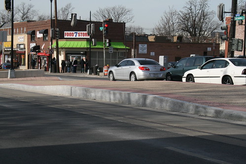
T Street renovations reveal old streetcar tracks

Old streetcar rails being removed from the 600 block of T St NW
The Howard Theatre is set to open in April. While construction crews are finishing the theater’s historic restoration, the District government is renovating the entire street in front of the theater. The streetscape project involves replacing the sidewalks, curbs, road pavement, storm drains, and lamp posts on the 600 block of T Street NW and along the one-block Wiltberger Street NW, which abuts the Howard Theatre.
Construction work started at the beginning of February. We were able to get this photo of construction crews removing the old streetcar tracks that were paved over after the streetcar system ceased operation in 1962. In fact the old tracks still lie under many of Washington’s streets; paving them over was cheaper than tearing them up.
Though the streetcars ran along 7th Street/Georgia Avenue and along Florida Avenue, a 1958 streetcar map shows that a short connector linked both of these routes along the 600 block of T Street NW.
DDOT’s plans for the block are ornate and are designed to complement the restored arts venue. The street will feature decorative pavement for both the sidewalk and the roadway. We certainly hope the decorative pavement can withstand the stress of traffic once the street reopens.

Below is the plaza section where T Street intersects Florida Avenue in front of Zenebech. Earlier today we noticed that the sculpture plinth is in place already. The deciduous tree will certainly be a welcome addition to what is now an uninterrupted expanse of concrete.


Rails in Benning Road
We’ve written before about DDOT’s plan to build a streetcar system throughout the District. The city already owns three streetcars and is storing them temporarily in Greenbelt.
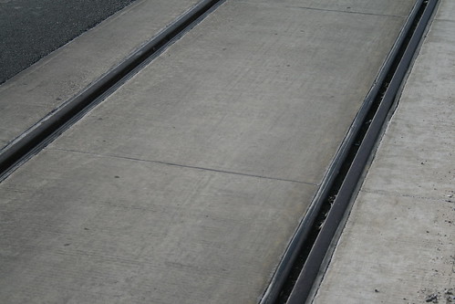
The city recently installed rails and mini-platforms (see below) along the western end of Benning Road in Northeast Washington. Here are some photos we took this weekend of our shiny new infrastructure.
Above: Median platform at 19th Street NE.
Below: The tracks are embedded in a linear concrete pad that runs along the inner lanes of Benning Road.
The rails will continue along H Street NE toward Union Station.
Rhode Island Bound
With some careful consideration of DDOT’s proposed streetcar system, we suggest one alteration regarding the Rhode Island Avenue route. DDOT would prefer to run the purple route all the way down Rhode Island Avenue from P.G. County to Florida Avenue (at the edge of LeDroit Park), at which point it would follow Florida Avenue northwest to U Street, then down 14th Street to K Street.
We suggest that DDOT study placing the route entirely along Rhode Island Avenue all the way to downtown. Rhode Island Avenue empties out onto M Street, which the route would follow onto New Hampshire Avenue and then to Washington Circle in Foggy Bottom, where it could turn back.
Our proposed route has several advantages:
- It’s more intuitive. Rather than zig-zagging from Rhode Island Avenue to Florida Avenue to U Street then to 14th Street, then to K Street, the proposed route would simply follow Rhode Island Avenue all the way downtown. In fact, the route would become synonymous with the avenue, which is well known in the city and P.G. County as one of the main arteries. Riders familiar with the city but unfamiliar with the map will know exactly where the line goes.
- It avoids congestion on Florida Avenue. The 400, 500, and 600 blocks of Florida Avenue NW, on the edge of LeDroit Park, are frequently congested even during non-rush hour periods. Avoiding this section of road will reduce delays on the line.
- It’s more direct. DDOT’s route would take inbound passengers southwest along Rhode Island Avenue, and then northwest at Florida Avenue. Our alignment cuts the distance from LeDroit Park to Washington Circle by 29% (2.0 miles versus 2.8 miles).
- It’s more central to Shaw. The proposed route passes closer to the center of the Shaw neighborhood and passes by the Metrorail station entrance at 7th Street and R Street on Rhode Island Avenue. DDOT’s alignment passes on the edge of Shaw and two blocks from the Metrorail entrance.
- It provides more redundancy downtown. In the event of a closure of the K Street Transitway (for an accident, vehicle breakdown, street protest, etc.) anywhere from Washington Circle to 14th Street, the proposed route provides a parallel set of tracks just a few blocks away allowing a quick diversion around the trouble spot.
This proposal will not reduce coverage at all, since the route we suggest eliminating is already covered by at least one other proposed line.
The map below illustrates the difference. Click the buttons to switch between the DDOT proposal and the DDOT proposal with our amendment.


K Street Transitway Video
To follow up on the previous post on reviving the city’s streetcar network, d. has produced a video simulation of what the K Street Transitway will look like. Skip ahead to 5:07 to see the streetcar cameo.
Streetcar Open House

The District Department of Transportation (d.) is holding several open houses to display the department’s long-term and short-term plans for expanding transit in the city. These plans, often dubbed DC’s Transit Future, have been on the record since 2002 and a few of the recommendations (the creation of Circulator routes and Metro Extra service) have been in place for some time now.
The most ambitious feature, a network of streetcars, is still in the works. As it stands, the city already owns a set of three streetcars (one is pictured above) and is storing them in Plzeň, Czech Republic, until they can be deployed on the reconstructed H Street in Northeast. The first segment of the reincarnated streetcar system was set to be the short Anacostia streetcar “demonstration” project, but a series of delays and heavy lobbying by Councilmember Tommy Wells (D – Ward 6) have caused Mayor Fenty to reallocate the streetcars to H Street NE (more on the trouble with that below).
Earlier this evening d. released its latest proposal for an eight-line, 37-mile streetcar network to be built in three phases. Three of the proposed routes will border LeDroit Park:
- Orange Route – Georgia Avenue-U St-Downtown-Foggy Bottom-Waterfront: In Phase 1 this section will run along Georgia Avenue from Petworth to Florida Avenue, at which point it will turn west to follow Florida Avenue onto U Street, then south on 14th Street into downtown. At K Street, it will turn west and follow the forthcoming K Street Transitway to Washington Circle in Foggy Bottom. In Phase 3, the train will be rerouted so that it stays on 14th Street all the way downtown, where it will turn east on F Street, then south on 7th Street all the way to the Waterfront on M Street SW. The route will end on 4th Street SW at Fort McNair.
- Purple Route – Rhode Island Avenue-Florida Avenue-U St-Downtown-Foggy Bottom: Phase 2 calls for constructing a line along Rhode Island Avenue in Prince George’s County all the way to Florida Avenue on the edge of LeDroit Park, at which point, the route follows Florida Avenue (a very congested section of roadway) northwest and onto U Street, then south on 14th Street to K Street. At K Street, it will turn west and follow the forthcoming K Street Transitway to Washington Circle in Foggy Bottom.
- Green Route – Woodley Park-Adams-Morgan-U St-Florida Avenue-Capitol Hill-Anacostia-Southeast: Phase 2 also calls for a crosstown route route to pass beside LeDroit Park between Woodley Park and Southeast Washington. The route will start on Calvert Street in Woodley Park, cross the Ellington Bridge into Adams-Morgan, where it will follow 18th Street south to U Street, where it will turn east all the way onto Florida Avenue (at 9th Street). It will follow Florida Avenue all the way to 8th Street NE, on which it will travel south into Capitol Hill to the Navy Yard at M Street SE. It will cross the Anacostia River on the future 11th Street Bridge and follow MLK Avenue through Anacostia and into the far southern reaches of the District.
We have created a map illustrating how the streetcar plan will enhance mobility for LeDroit Park.

Don’t be mistaken; these are just three of eight lines under consideration.
Though we are enthusiastic about the plan, we harbor several concerns about the future direction of this effort.
First, the city must sustain the political will to follow through on these projects. Building a streetcar network requires money and popular support. We have lamented privately that DC’s leadership often ignores transit improvements, but it appears that the projects have the support of Council Chairman Vincent Gray (D – At large) and Councilmember Wells as well as the support of Mayor Fenty and d. director Gabe Klein. However, the fact the Anacostia line is several years late illustrates some of the complexities involved with building a new system.
Second, some jurisdictions have seen the price tags of such improvements and lost their nerve. Some have sought to build cheaper alternatives to streetcars by providing buses that run in their own dedicated bus lanes. This mode, called bus rapid transit, usually requires payment before boarding and has worked well in some cities (e.g. Curitiba, Brazil). The problem is that in America, buses carry a negative image and will have difficulty attracting middle-income riders who would otherwise drive. Additionally, streetcars have higher ridership capacities and are better able to attract development to their routes— no one has ever marketed a property by noting its proximity to a bus stop, after all.
Third, streetcars require overhead catenary wires for power. For the past 120 years Congress has prohibited such wires within the L’Enfant Plan (roughly the area bounded by Florida Avenue, the Potomac, and the Anacostia) and in Georgetown. Unless Congress repeals the ban, streetcars will stop at Florida Avenue or the city will have to invest in some alternative, experimental source of power (e.g. batteries or electromagnetic induction through the street pavement).
Either way, it’s important for residents to ask questions and show their support. The Ward One open house is set for Monday, October 26, 2009, from 7 – 8:30 pm at the Columbia Heights Education Campus, 3101 16th Street, NW (metro: Columbia Heights). d. is hosting open houses throughout the city through November 4.


Recent Comments