
1925 photo of Griffith Stadium also shows LeDroit Park
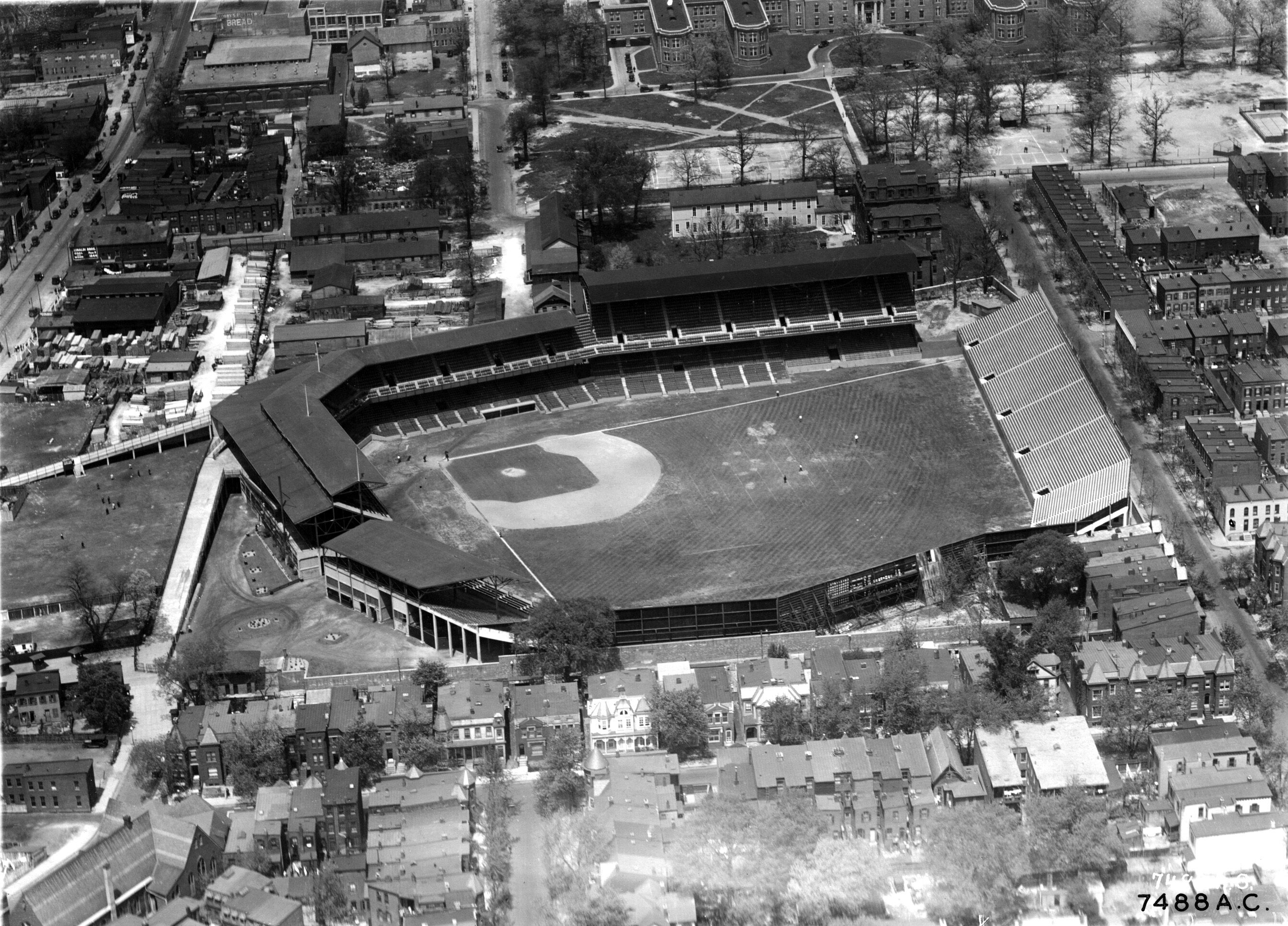
Every time I come across a photo of Griffith Stadium, which stood where Howard University Hospital now stands, I look carefully for an angle of LeDroit Park. By way of Ghosts of DC comes this superb 1925 aerial shot looking north at the stadium and part of the neighborhood.
The east-west street in the foreground is the 500 and 600 blocks of U Street NW. Zoom in and look around. Notice the streetcars on Georgia Avenue in the upper-left corner of the photo. Notice the previous incarnation of the Florida Avenue Baptist Church in the lower-left corner.
The stands beyond Griffith’s straightaway center field backed up to 5th Street from Elm to V Streets. Can you imagine hearing the crack of a bat and roar of crowds during a Senators game?
Also note what’s no longer standing. All but seven houses pictured east and north of the stadium have since been demolished, replaced with parking garages, parking lots, public housing, or academic buildings. Nearly all of these houses would be illegal to rebuild today under our 1950s zoning code, which mandates minimum lot sizes and house widths to which much of historic LeDroit Park does not conform.
Photo source: National Archives
Census data for LeDroit Park
In preparation for redistricting Ward 1’s ANCs, the DC Office of Planning has released block-by-block demographic data for the District. We have combined the data for the blocks that comprise LeDroit Park to create a LeDroit Park census.
Analyzing U.S. Census data for LeDroit Park proves difficult because the of the way census tracts are drawn. Our census tract, 34, combines LeDroit Park and Howard University. Dorms on the northern end of the campus, far away from LeDroit Park, account for 717 of the tract’s 4,347 residents, thus skewing tract data. Furthermore, the tract also inclues several blocks bounded by Rhode Island Avenue NW, Florida Avenue NW, and 2nd Street NW.
Fortunately, the Census Bureau provides data for each block, allowing us to combine the statistics for those blocks in LeDroit Park, while excluding the Howard University campus. In the map below, we have outlined the tract in blue and shaded the blocks for LeDroit Park in red.
View LeDroit Park Census in a larger map
Though LeDroit Park started out as an exclusively white suburban neighborhood, by 1910 the neighborhood was almost entirely black. Today, 100 years later, the neighborhood is 70% black and is continuing to diversify.

However, when looking at the numbers on a block-by-block basis, you see that the neighborhood demography, must like that of the District itself, is unevenly distributed.
The block bounded by 5th Street, T Street, 6th Street, and U Street is 53% white, the highest in the neighborhood. Likewise, the block containing the Kelly Miller public housing is 91% black, the highest percentage in the neighborhood. The block containing the arch and the Florida Avenue Baptist Church comes closest to black-white equilibrium at 44% and 49% for each group respectively.

When looking at total population numbers for each block, you see that the two most populous blocks contain Howard University dorms. The block bounded by 2nd Street, T Street, 3rd Street, and Elm Street has 382 residents and contains Slowe Hall, which houses 299 students.
The second most populous block contains the new park. However, it also contains Carver Hall, which itself houses 173 students. Certainly these blocks are big, but the fact that their population numbers are off the chart has more to do with student dorms than with any inherent difference in housing density.

Finally, when we look at housing vacancy, we see that the block bounded by 5th Street, T Street, 6th Street and U Street has 38% of its housing units vacant. We’re not sure what’s causing this number, but we suspect that the apartment building at 5th and U Streets NW boosted the vacancy rate. The building has since been finished and is fully rented.
The block with the second-highest rate of vacancy contains the now-renovated Ledroit Place condo building at 1907 3rd Street NW.

It would be interesting too look at other data, including household income, car ownership, and age distribution for the neighborhood. However, the Office of Planning’s spreadsheet only covered population numbers, racial distribution, and housing unit numbers, so those are the metrics we graphed.


Recent Comments