
Plow-Spotting with GPS

The District government uses GPS to track its plows and publishes the location data for the public to see. Enter in your address or an intersection and watch an animated history of plowing over the past few days near you.
Please recall that under District law, property owners should have cleared their sidewalks by now. It’s certainly no fun, but it helps life return to normalcy.
Going for a Record
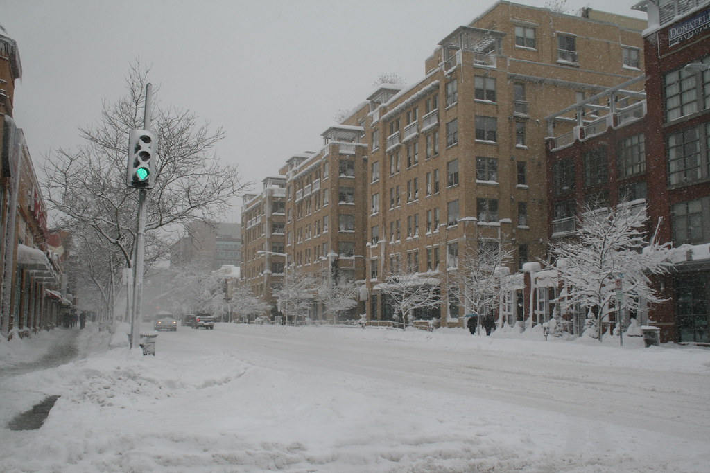
The record snow that accumulated this weekend brought us out to snowball fights and sledding in Meridian Hill Park. With few stores open and few roads passable, Saturday was a true holiday in the old-fashioned sense.
Howard University Hospital’s groundskeeper was out in heartbeat clearing the hospital’s sidewalks while contractors cleared the hospital’s parking lot. Pretty impressive!
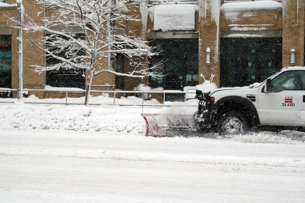
Neighbors dug their cars out of snow and the usually busy Florida Avenue carried more pedestrians then automobiles. The District government sent numerous plows along U Street and Florida Avenue, largely neglecting (understandably) the quiet streets of LeDroit Park.
You didn’t need a 4×4 to get around this weather. These two girls found that a daddy-powered sled was the most convenient form of transportation.

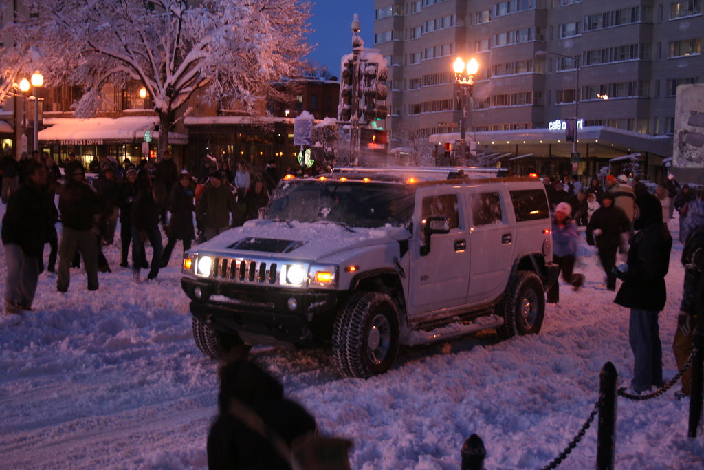
In Dupont Circle, hundreds of people gathered for a snowball fight. We caught the end of it:

Is a white Hummer camouflaged when it’s in the snow? These snowballers were able to spot and pelt it.
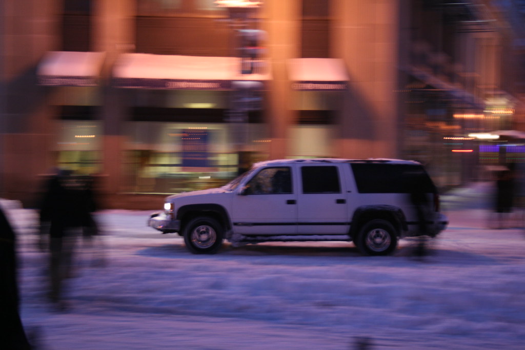
This Suburban sped away as soon as the light turned green.
For cars in LeDroit Park, Fourth and Fifth Streets are passable, but the east-west streets are better left to the four-wheel-drives.
More snow is expected Tuesday night and during the day on Wednesday. Were Pres. William McKinley still alive today, he would not only argue the merits of a gold standard with Rep. Ron Paul, but would also scoff at this relative “dusting”. Though we’ve recorded 45 inches so far this winter, the winter of 1898-99, during McKinley’s administration, set the city’s record, dumping a total of 54.4 inches on the capital!
If you’re tired of the snow, be glad you don’t live in Québec City, which suffers 124 inches of snow each winter… on average!
Putting A Lid On It

Opening day for the Dupont Circle underpass
In 1950 the District opened a vehicular underpass allowing Connecticut Avenue to dive under Dupont Circle. The underpass, which still exists today, is flanked by two abandoned (and hidden) streetcar tunnels that sit behind each rusticated retaining wall. In March 2007, DDOT finished refurbishing the automobile underpass, but the city missed an excellent opportunity to restore the gashed avenue above.
Between Dupont Circle and Q Street, the underpass is “daylighted”— exposed to the sky— needlessly monopolizing space from the block’s active street scene.

Our solution for street reclamation is simple: cap the underpass for that one block.
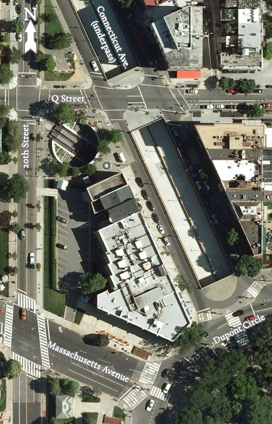
Connecticut Avenue, for that one block, would become much like P Street or Nineteenth Street (on the north side) as they approach the circle. Each provides a travel lane and a parking lane in each direction— far different from the cramped and highway-like atmosphere on Connecticut Avenue.
The businesses along the block would benefit from sidewalks that will double in width as well as from easier access from the roadway, parking spaces and sidewalk on the opposite side of the avenue. The increased sidewalk space will relieve the pedestrian congestion on the sidewalks (particularly on the east side) and provide space for outdoor seating and for stores’ promotional placards. Pairs of facing street benches perpendicular to the avenue will provide more seating for shop patrons and passersby.
Furthermore, the ample, seamless space would provide another truck-accessible venue for weekend farmers’ markets or art sales and other events that a stodgy National Park Service may not permit in the circle itself.
Plans are already in motion to build over I-395 and the National Capital Planning Commission dreams of covering the E Street Expressway in Foggy Bottom east of the Kennedy Center. Compared to those proposals, this one is simpler, easier, and cheaper and would benefit more residents.
Update: We considered the idea of a medial park, but worried that it would suffer from desolation due to its separation from the active sidewalks. Though certainly better than the status quo, we suspect fewer people would want to sit in what is essentially a grassy street median. That said, it would certainly be cheaper to build— and money is no small matter in this case!
The advantage of our proposal above is that it enhances existing spaces (the sidewalks) whose heavy use warrants improvement.
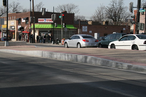
Rails in Benning Road
We’ve written before about DDOT’s plan to build a streetcar system throughout the District. The city already owns three streetcars and is storing them temporarily in Greenbelt.
The city recently installed rails and mini-platforms (see below) along the western end of Benning Road in Northeast Washington. Here are some photos we took this weekend of our shiny new infrastructure.
Above: Median platform at 19th Street NE.
Below: The tracks are embedded in a linear concrete pad that runs along the inner lanes of Benning Road.
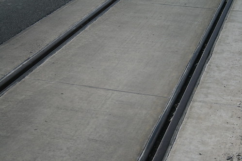
The rails will continue along H Street NE toward Union Station.
Lane Champlain

Photo by M.V. Jantzen
The District recently renovated and reopened Champlain Street to cars under the Marie Reed Center. The new street is one-way southbound for cars and includes a northbound contraflow bike lane. The reopened street will improve street connectivity between Adams Morgan and the U Street corridor. Currently, much of the car traffic is forced onto Ontario Road on the east and Eighteenth Street on the west.
The northbound contraflow bike lane will connect nicely to the westbound bike lane on V Street (mapped below). Though bicycles are entitled to ride on all District streets, LeDroit residents who prefer bike lanes will find a more relaxed route along V Street (from Vermont Avenue) westward to Florida Avenue, then northward on Champlain Street.

Champlain Street and vicinity. The blue line marks the northwestern edge of the L'Enfant Plan
The roadway just south of the Marie Reed Center has been renamed Champlain Street to signify its continuation from the north. Its old namesake, Old Morgan School Place, has since been shortened from its former L-shape to its one remaining block between the Reed Center and the PEPCO substation.
We applaud DDOT and Councilmember Jim Graham (D-Ward 1), who spearheaded the reopening, for accommodating cyclists and connecting the street grids. Connected streets alleviate traffic jams as they provide more alternatives routes when the main streets become unexpectedly crowded.
Bars, Bikes, and Buildings

Highlights from Thursday’s monthly meeting of ANC1B: New restaurants and lounges are on their way to U Street. Office construction in the District may be hurting, but neo-Victorian townhouses will replace an old parking lot on Vermont Avenue. Fifteenth Street’s protected bike lane will finally enter Ward 1.
Bar Fights
Several commissioners bickered over the process of approving liquor licenses— in this case a procedural dispute— but the commission relented and took no further action on Cuckoo Marans and the U Street Music Hall, both of which we wrote about earlier. The ANC typically protests all new licenses officially as a means to goad applicants to reach voluntary agreements with the ANC. These voluntary agreements tend to be less permissive than the District’s standing liquor laws.
In new business, a new liquor license applicant presented his plans for Café Society, which he billed as an affordable and upscale (oxymoron?) steakhouse that will feature steaks (of course) and local produce. The 139-seat steakhouse will occupy the ground floor and upper floors (and a roof terrace) of the newly renovated building on the northeast corner of Fourteenth and U Streets. Cuckoo Marans will occupy the basement of the same building.
Against the Grain
DDOT sought and received the ANC’s support for extending the Fifteenth Street southbound contraflow bike lane from U Street northward to the foot of Meridian Hill at W Street. Fifteenth Street is one-way northbound from Massachusetts Avenue on the edge of downtown all the way up to Columbia Heights. Though one resident complained of renegade cyclists disobeying traffic laws, the ANC voted to support the lane anyway. Commissioner Brianne Nadeau (ANC1B05 – Meridan Hill) expressed her desire to see the lane extended all the way up Meridian Hill to Euclid Street, but DDOT is not seeking that extension just yet, though they seem to be studying it, if informally.
When DDOT began installing the contraflow lane in November, Councilmember Jim Graham (D – Ward 1) flipped out at DDOT’s alleged inadequate notification of his constituents. In response DDOT built the lane along Fifteenth Street in Ward 2, but stopped at Ward 1’s boundary at U Street. A chastened DDOT now has the ANC’s approval.
Home Again
A local developer and his architect presented plans to build three townhouses (two units each) on the south side of the parking lot at T Street and Vermont Avenue. The architect displayed several handsome elevation drawings, all in a Victorian style, that match the rich neighboring architecture. Each of the three townhouses will feature alley-accessible garages. The developer will also replace the existing concrete sidewalk with brick, our favorite paving material. The north side of the parking lot will also be redeveloped as part of a separate project.
Opposing Metro Service Cuts
Have you ever waited 30 minutes for a Metro train? That may become the norm on evenings if WMATA has its way. The transit agency is proposing to close a $40-million budget gap for the current fiscal year with a variety of measures, including the elimination of some jobs, the closure of certain mezzanines (including Shaw’s R Street entrance) at night, and by the reduction of call-center hours among other things. The worst part of the proposal, however, involves the reduction of train frequencies in the early mornings, late-nights and on weekends. One part of the proposal also calls for eliminating the eight-car trains that run on the Orange and Green Lines.
Many transit and urban planning bloggers around town have are warning of the “death spiral” that occurs when public agencies sharply reduce the quality and reach of their core services. Since reducing the frequency of trains reduces the intrinsic value of the transit system, the cuts risk driving away customers, thus ensuring a vicious cycle of ridership declines and subsequent revenue declines and service cuts.
The proposed frequency reductions mean that on Saturdays, Metro will actually run less often than the subway of Los Angeles. Los Angeles!
Our ANC Commissioner Myla Moss (ANC1B01 – LeDroit Park) emailed Councilmember Jim Graham (D – Ward 1) criticizing WMATA’s plan to close Shaw’s R Street entrance (the south entrance) late at night. Though we see how mezzanine closures will inconvenience a few riders by a few minutes at a few stations, we believe the real disservice is happening on the platforms: reducing train frequency will inconvenience all riders at every station.
Mr. Graham, we should remind you, is also the chairman of the WMATA board, which will hold a hearing and vote on the cuts on January 7. We have already emailed Mr. Graham to alert him to the dangers in some of the proposed cuts. We encourage you to let him know what you think.
Jim,
Can you imagine waiting 30 minutes for a Metro train to arrive? WMATA’s budget-cut proposal will leave many riders doing just that.
I’m worried that WMATA’s proposal to drastically cut rail and bus service is a terrible mistake that may lead to a “death spiral” in ridership and revenue. The proposed cuts to train and bus frequency will further turn off riders from the system, since reducing service makes the system intrinsically less valuable at a time when the District’s population is rising.
Your constituents in Ward One, a ward with some of the city’s highest population densities and lowest rates of car-ownership, will suffer greatly from reduced mobility options.
I urge you to vote against the proposal and request that WMATA management return with other options (e.g. fare increases, pay/benefit freezes, further staff reductions, entrance closings) that do not sacrifice the system’s core mission of providing decent mass-mobility.
Let us not follow the mistake of New York City, which, when faced with tax revenue shortfalls in the 1970s, reduced basic city services sharply. The reduction in services (park cleanings, street repairs, street sweepings, etc.) reduced the city’s attractiveness and further exacerbated the city’s financial woes— why stay in the city if the services are declining? Please do not let Metro (and DC, by extension) suffer a similar fate. Your constituents (and I am one of them) are heavily reliant on convenient and frequent transit service, which gives the District a competitive advantage over other cities and over the surrounding jurisdictions.
Eric Fidler
LeDroit ParkP.S. I am willing to pay a reasonable fare increase to avoid service cuts.
P.P.S. These proposed cuts will make trains less frequent than they are in Los Angeles, Boston, Philadelphia, Chicago, Montreal, Toronto, and New York. I can’t imagine a world in which even L.A. has better train service than Washington.
Let’s hope the board avoids these core-service reductions.
The Streetcars Have Landed
We wrote earlier about the rebirth of DC’s streetcar system and even suggested our own alignment for a full-length Rhode Island Avenue line.
As we reported, the city’s three streetcars were collecting dust in the city of Plzeň in the Czech Republic, where they were manufactured. Today they completed their transatlantic voyage and landed at the Port of Balitmore. DDOT recorded the event:
The streetcars will be transported to the Greenbelt Metro railyard, where WMATA staff will maintain them until the tracks are ready.
Speaking of tracks, DDOT has finished laying down the streetcar tracks along Benning Road in Northeast.

DDOT took this photo on Benning Road NE at 17th Street NE, just two blocks outside the L’Enfant Plan, where overhead catenery wires are prohibited by law— another issue DDOT will have to resolve.
DDOT is ambitiously moving ahead with the streetcar plan, but Councilmember Jim Graham (D – Ward 1) told us that though he may not see the streetcars in his lifetime, I’d see them in mine (you’re writer is 25). Not fully reassuring, but better than nothing.
Old Street Names

Careful observers occasionally spot the old street signs adorning a few of the light poles in LeDroit Park. When the neighborhood was originally planned, most of the streets were named after trees. LeDroit Park’s street system didn’t fit with the L’Enfant Plan in either name or alignment—much to the dismay of the District commissioners—and the street names were eventually changed to fit the naming and numbering system.
A perusal of old maps reveals that the street names changed over time, not all at once. Elm Street is the only street that has retained its name. Since your author lives on Elm Street he has learned to respond to puzzled faces that know that Elm doesn’t fit the street naming system: “It’s kinda like U-and-1/3 Street”.
Anna J. Cooper Circle didn’t have a name at all until 1983, when it was restored to its circular form after a decades-long bisection by Third Street.
Just outside of LeDroit Park, the city renamed a few streets as well: 7th Street Road became Georgia Avenue and Boundary Street, the boundary of the L’Enfant Plan, became Florida Avenue.
Here is a table matching the current street names with their previous names.
| Old Name | Current Name |
| Le Droit Avenue | 2nd Street |
| Harewood Avenue | 3rd Street |
| Linden Street | 4th Street* |
| Larch Street | 5th Street |
| Juniper Street | 6th Street |
| Elm Street | (same) |
| Boundary Street | Florida Avenue** |
| 7th Street Road | Georgia Avenue** |
| Oak Court | Oakdale Place |
| Maple Avenue | T Street |
| Spruce Street | U Street |
| Wilson Street | V Street** |
| Pomeroy Street | W Street** |
| (unnamed before 1983) | Anna J. Cooper Circle |
| * For a short period, 4th Street was called 4½ Street. ** Though these streets were just outside the original LeDroit Park, we have included them for reference. |
|
Signs bearing the old street names have reappeared in the neighborhood, and according to the Afro-American, were put up in 1976: “The LeDroit Park Historic District Project was instrumental in getting the D.C. Department of Transportation to put up the old original street names for this Historic District Area under the present street name signs”.1
Unfortunately, some of the signs are showing their 33 years of weather, as this sign at Third and U Streets shows.

Eventually these signs will have to be replaced, but rather than placing the old names onto modern signs using a modern typeface, we suggest something that evokes the history without being mistaken for the current street name:

White text on a brown background is the standard for street and highway signs pointing to areas of recreation or cultural interest. Seattle started using the color scheme to mark its historic Olmsted boulevards and New York has long used the combination for street signs in its historic districts. The adoption of this style of sign would alert visitors and residents to the neighborhood’s historic identity while the different color and typeface would prevent confusion with the actual street names (U St NW in this case). Typographers would be pleased by the use of Big Caslon Medium, a serif typeface based on the centuries-old Caslon typeface.
- Hall, Ruth C. “Historic Project”. Washington Afro-American. 1 May 1976.
Bike Sharing

One wonderful feature of living in LeDroit Park is not only its proximity to downtown, but the variety of options in getting downtown.
A cab ride to Chinatown is only about $5.50. A walk is only 25 minutes. The Green and Yellow lines stop at 7th and S Streets in Shaw. Numerous buses run along 7th Street and Georgia Avenue toward downtown. For those of us who can’t tolerate the 70s buses that stop every block, the limited-stop 79 stops at 7th and T Streets, just two stops before downtown.
Yet there is another frequently overlooked option: picking up a SmartBike at 7th and T Streets and riding downtown to another bike station.
SmartBike was established by the advertising company Clear Channel Outdoor as a quid-pro-quo for having the right to advertise in the city’s bus shelters. For a flat, annual $40 fee, subscribers receive an RFID card (just like a SmarTrip card) that they wave at a station, which then unlocks a bike in response. A member may use the bike for up to three hours and can return it to any station.
When the weather is nice, your author frequently picks up a bike at 7th & T Streets and rides it to work near Metro Center. He returns it to a station located on his office’s block at 12th and G Streets (across the street from Macy’s). Since the cost is a flat $40 per year, there is no additional cost for each ride.
DDOT, which pushed Clear Channel for this program, is ultimately responsible for bringing the idea to the District. DDOT Director Gabe Klein, formerly a Zipcar executive, promises to expand the program by next spring. Currently there are only ten stations, which limits the program’s utility for many residents. Since a bike must be returned to a station, but may be returned to any station, SmartBike is subject to something akin to the the network effect, i.e. the more stations there are, the more inherently useful the system is.
Though Mr. Klein did not specify if the SmartBike expansion would use a new bike vendor, Greater Greater Washington noticed that the Montréal newspaper Le Soleil (The Sun) is reporting that their hometown bike-sharing champion, named Bixi, is preparing to sign a deal with the District, presumably replacing the current Clear Channel arrangement. The main advantage of the Bixi bikes is that their stations are solar-powered and can be deployed virtually anywhere, whereas the current stations require the costly (and often complicated) installation of power lines under existing sidewalks downtown.
Hopefully by next spring we will be able to pick up a bike and tool on over to places other than downtown.


Recent Comments