
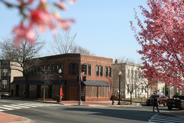
Pizzarro tip-toes into LeDroit Park
When the Spanish conquistador Francisco Pizarro comes knocking, your empire is over. In 1532 he marched into Peru, captured and held the Incan emperor for a ransom, and, after the ransom was paid, executed the Incan emperor anyway.

It’s safe to assume, however, that the cleverly named Pizzarro, coming to 467 Florida Avenue, won’t portend a vicious bloodbath. Whereas Pizarro stormed into Peru, Pizzarro has quietly entered our midst. Some speculate it will be a cafe or a pizza restaurant (as though we don’t already have enough pizza options around here).
The new sign has been in place for several weeks and the interior is looking freshly remodeled. Even still, the dust collecting on the tables and we eagerly await the business’s opening, whenever that may be.
Historic fountains rot away in a local national park
Two century-old DC fountains sit decaying and neglected in the woods of a national park in Maryland. The fountains had been missing from the 1940s until they were rediscovered in the woods of Fort Washington National Park in the 1970s.
The top portion of the McMillan fountain, pictured below, was returned to Crispus Attucks park in the Bloomingdale neighborhood in 1983. In 1992 it was moved back to the fenced-off grounds of the McMillan Reservoir just a few blocks away.
The fountain was installed in 1913 at the McMillan Reservoir as a memorial to Senator James McMillan (R – Michigan), who is more remembered locally for his his ambitious McMillan Plan to beautify Washington. The fountain was dismantled in 1941, when the reservoir was fenced off from the public.


Top of the McMillan Fountain today (left) and in 1912 (right).
Though the top of the McMillan Fountain had been restored to the reservoir grounds, a Bloomingdale ANC commissioner told me the base of the fountain was in the woods in Fort Washington along with the remains of the fountain that stood at the center of the now-razed Truxton Circle.
I went to Fort Washington in search of these discarded works of art. I asked a park ranger where the fountain was and she drew me a map, saying that it stood in the park’s “dump” and partly behind a fence.
I went to the picnic area nearest the site and walked into the woods a short distance where I found a fence. Behind it stood piles of bricks and other discarded building materials.
Beside the site is a dugout that serves as the back court to Battery Emory, a concrete gun battery built in 1898 to protect the capital city from enemy ships.
As I passed through the unfenced dugout, I immediately spotted few granite blocks that served as the cornerstones of the base bowl. Though they are strewn about the ground, a 1912 photograph can help us identify what pieces went where.


A cornerstone sitting on the ground (left) formed part of the fountain’s bottom basin (right).
The elements of the fountain were stacked like totem pole. The bottom element features carved classical allegorical heads from whose mouths water gushed into the carved bowls below.


Fence material and tree debris cover the carved granite (left) that stood as the fountain base (right).
The next element of the stack is the fluted base to the top bowl.


Upside down on the ground (left) is the fluted base for the top bowl (right).
Several other large granite stones are stacked and marked with numbers, presumably to help in reassembly.

The site also contains the rusting remains of the fountain that stood at Truxton Circle, which formed the intersection of North Capitol Street, Florida Avenue, Lincoln Road, and Q Street. The circle was built around 1901 and the fountain installed there originally stood at the triangle park at Pennsylvania Avenue and M Street in Georgetown.

Truxton Circle stood at Florida Avenue, North Capitol Street, Q Street, and Lincoln Road from 1901 to 1940, when it was demolished to aid commuter traffic.
A newspaper at the time described it as one of the largest fountains in the city. The circle was removed in 1940 to ease the flow of commuter traffic. At that time, the fountain, which may date to as early as the 1880s, made its way to Fort Washington to rust in the woods.


The metal pedestal (left) held up the fountain bowl whose rim rusts in pieces on the ground (right). Notice the classical egg-and-dart pattern.
The fountain was also noted for the metal grates that stood near its base. Now these grates sit rusting in the woods.


If you want to see the fountain remains for yourself at Fort Washington National Park, go to picnic area C. Beyond the end of the parking lot is a restroom building and behind that is the fountain “graveyard.” A fence encloses part of the site, but you can enter through the large gap down the hillside.
Rather than tossing aside our city’s artistic patrimony, we should aim to restore these treasures to the neighborhoods from which they came. Public art is part of what differentiates cherished neighborhoods from unmemorable places.
These works remind us of the accomplishments and civic-mindedness of generations past and urge us to carry on the tradition of civic improvement for generations to come.
Bikeshare expansion passes over LeDroit Park
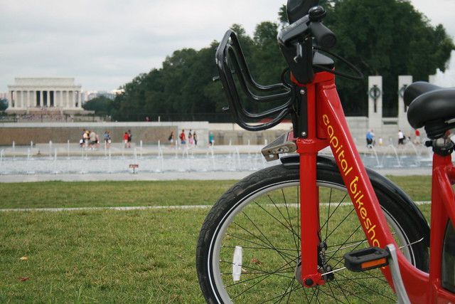
Capital Bikeshare, the District’s smashingly successful bikesharing system, will expand this fall. Unfortunately, the expansion plans for this fall exclude LeDroit Park.
The District and Arlington launched the system a year ago with 14 stations in Arlington and 100 in the District. This fall, DDOT will add 34 stations in the District. In our area, DDOT will add a station by the Shaw Library and another at 1st Street NW and Rhode Island Avenue NW in Bloomingdale.
These additions should help alleviate the pressure placed on the existing stations at 7th & T Streets NW in Shaw and at Florida Avenue and R Street NW in Bloomingdale. Currently, LeDroiters and Bloomingdalers compete to use these two stations and thus frequently leave the stations empty or full during rushhour.

Last week DDOT Director Terry Bellamy announced that the district will add 50 stations early next year. We hope that in this new round DDOT focuses more attention on LeDroit Park and other neighborhoods in ANC 1B.
For instance, a Capital Bikeshare station could easily go in at the Park at LeDroit’s south entrance at 3rd and Elm Streets NW. This location is central to the neighborhood and could bring some extra eyes to the park throughout the day.
Outside of LeDroit Park, there is a noticeable station gap in the northern reaches of Bloomingdale and around Cardozo High School.
Capital Bikeshare is particuarly successful in our part of DC for several reasons:
- Car ownership is relatively low compared to the rest of the nation, region, and city. This inclines people to bike more.
- Parking is particularly difficult on many neighborhood streets, thus making cycling more attractive.
- The historical development of this area has permitted the close proximity of commercial uses to residential uses. This means trips to shops and restaurants are short and easily made by bike.
- Downtown is a short ride away and biking is often faster than taking the bus.
“LE DROIT PARK. What Three Years Have Done.”
We came across this 1876 article documenting the initial improvements to the nascent LeDroit Park.
LE DROIT PARK. What Three Years Have Done.
National Republican
September 4, 1876Mr. James H. McGill, architect, has forwarded to the inspector of buildings, Mr. Thos. M. Plowman, a communication, in which he furnishes interesting information in relation to the improvements made in LeDroit Park within the last two years. He states that the different tracts of land composing the park were purchased at different times from June, 1872, to March, 1873, by Messrs. A.L. Barber & Co., and united by these gentlemen into one tract, which has been carefully surveyed and recorded. This park is in the form of an equilateral triangle, with one side resting on Boundary street [now Florida Avenue] and reaching from Seventh street eastward to Second street, and contains fifty acres. Until its subdivision by the present proprietor the eastern tract had been used for private residences and grounds, and the western portion had laid uninclosed for several years, and had been used as a public common. Improvements were soon commenced on a liberal scale; a handsome pattern of combination wood and iron fence was adopted and built all along the entire front and a board fence all along the rear, making one inclosure. All the interior fences were removed, and the lots thrown in together, affording a continuous sward. Streets were graded, graveled and guttered, brick sidewalks were put down, and gas, water and sewer mains laid.
The erection of buildings was commenced in July, 1873, since which time eight large brick residences have been erected on the north side of Maple avenue [now T Street] and two on the south side, costing from $4,000 to $12,000 each; ten houses on the north side and ten on the south side of Spruce street [now U Street], at an average cost of $3,500; two houses on the north side of Elm street, costing $3,000 each; four houses on east side, and five on the west side of Harewood avenue [now 3rd Street],costing from $4,000 to $10,000 each. A very superior stable and carriage-house has been completed for A. Langdon, esq., and another is in course of erection for A. R. Appleton, esq. Up to this date forty-one superior residences and two handsome stables have been constructed, at a cost of about $200,000. These houses are either built separately or in couples; are nearly all of brick; of varied designs, no two being alike either in size, shape or style of finish, or in the color of exterior. About $4,000 has been expended in the purchase and planting of ornamental shade trees and hedges, and about $50,000 in street improvements. About 4,500 lineal feet of streets have been graded and graveled, 9,000 feet of stone and brick gutters laid, 5,000 feet of brick pavement, 4,000 feet of sewer mains, 3,550 feet of water mains and 3,800 feet of gas mains laid. All of this expense has been by the proprietors of the property without a dollar from the District or authorities, and all the work has been done in the best and most liberal manner, under the direction of Mr. McGill. The plan contemplates the finishing of all its streets and the erection of two hundred tastefully-designed, conveniently-arranged and well-built detached and semi-detached residences, and when completed cannot fail of being a credit to all concerned. During the time stated the value of improvements constructed in other portions of the county amount to upwards of $100,000.
Census data for LeDroit Park
In preparation for redistricting Ward 1’s ANCs, the DC Office of Planning has released block-by-block demographic data for the District. We have combined the data for the blocks that comprise LeDroit Park to create a LeDroit Park census.
Analyzing U.S. Census data for LeDroit Park proves difficult because the of the way census tracts are drawn. Our census tract, 34, combines LeDroit Park and Howard University. Dorms on the northern end of the campus, far away from LeDroit Park, account for 717 of the tract’s 4,347 residents, thus skewing tract data. Furthermore, the tract also inclues several blocks bounded by Rhode Island Avenue NW, Florida Avenue NW, and 2nd Street NW.
Fortunately, the Census Bureau provides data for each block, allowing us to combine the statistics for those blocks in LeDroit Park, while excluding the Howard University campus. In the map below, we have outlined the tract in blue and shaded the blocks for LeDroit Park in red.
View LeDroit Park Census in a larger map
Though LeDroit Park started out as an exclusively white suburban neighborhood, by 1910 the neighborhood was almost entirely black. Today, 100 years later, the neighborhood is 70% black and is continuing to diversify.

However, when looking at the numbers on a block-by-block basis, you see that the neighborhood demography, must like that of the District itself, is unevenly distributed.
The block bounded by 5th Street, T Street, 6th Street, and U Street is 53% white, the highest in the neighborhood. Likewise, the block containing the Kelly Miller public housing is 91% black, the highest percentage in the neighborhood. The block containing the arch and the Florida Avenue Baptist Church comes closest to black-white equilibrium at 44% and 49% for each group respectively.

When looking at total population numbers for each block, you see that the two most populous blocks contain Howard University dorms. The block bounded by 2nd Street, T Street, 3rd Street, and Elm Street has 382 residents and contains Slowe Hall, which houses 299 students.
The second most populous block contains the new park. However, it also contains Carver Hall, which itself houses 173 students. Certainly these blocks are big, but the fact that their population numbers are off the chart has more to do with student dorms than with any inherent difference in housing density.

Finally, when we look at housing vacancy, we see that the block bounded by 5th Street, T Street, 6th Street and U Street has 38% of its housing units vacant. We’re not sure what’s causing this number, but we suspect that the apartment building at 5th and U Streets NW boosted the vacancy rate. The building has since been finished and is fully rented.
The block with the second-highest rate of vacancy contains the now-renovated Ledroit Place condo building at 1907 3rd Street NW.

It would be interesting too look at other data, including household income, car ownership, and age distribution for the neighborhood. However, the Office of Planning’s spreadsheet only covered population numbers, racial distribution, and housing unit numbers, so those are the metrics we graphed.
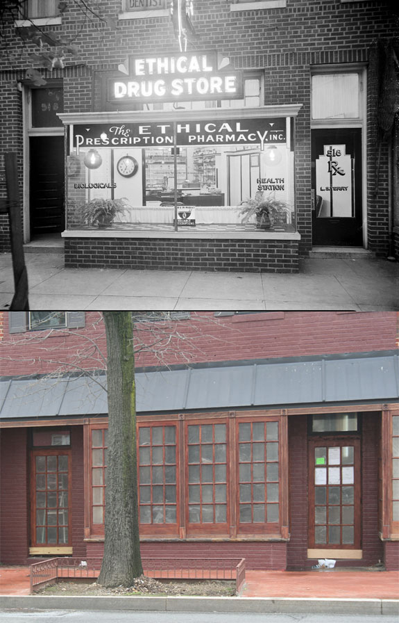
Before Shaw’s Tavern there was Ethical Pharmacy
This is the fourth in a series of the Scurlock photos. Read the others.
We have reported before on the coming of Shaw’s Tavern to the building (pictured above) at the southeast corner of 6th Street and Florida Avenue. It turns out that the bar at Shaw’s Tavern will not the be the first establishment to stir up elixirs at that location.
While perusing the Smithsonian’s Scurlock photo archives, we found that one of the building’s previous tenants was the Ethical Drug Store (also known as Ethical Prescription Pharmacy and Ethical Pharmacy), one of the many black-owned businesses along the 400 – 600 blocks of Florida Avenue NW.
Pharmacist Lewis Terry (1904- 1978) graduated from pharmacy school at Temple University in 1928. The following year he opened Ethical Pharmacy at 518 Florida Avenue NW. The pharmacy had filled 1 million prescriptions by 1953 earning him a special honor from Temple. Though Mr. Terry sold the business in the mid-60s, the pharmacy stayed in operation until the 1990s.
The name Ethical Pharmacy is a relic of a professional division in the pharmacy field a century ago. An “ethical pharmacy” proudly devoted itself solely to filling prescriptions and did not sell other extraneous products as modern drug stores, such as CVS, do today. The use of ‘ethical’ was a high-minded misnomer since a pharmacist could sell other wares ethically or devote himself exclusively to quack medicine.
The Scurlock Studio photographed the pharmacy in 1937 and again in 1950. We have included both photo shoots below.
1937
Here is a photo Addison Scurlock took of Ethical Pharmacy in 1937:
[Toggling between now and then photos will not work in RSS readers. View the actual post]
Here are some other shots of the interior. Though the Smithsonian has no date for the first two, we suspect they was shot in the 1930s. The third photo is dated 1937 and judging from the change in the interior, we suspect the pharmacy had undergone some sort of renovation to appear more modern.


1950
Mr. Scurlock photographed the pharmacy again in July 1950:

[Toggling between now and then photos will not work in RSS readers. View the actual post]
He also took more shots of the interior in 1950:


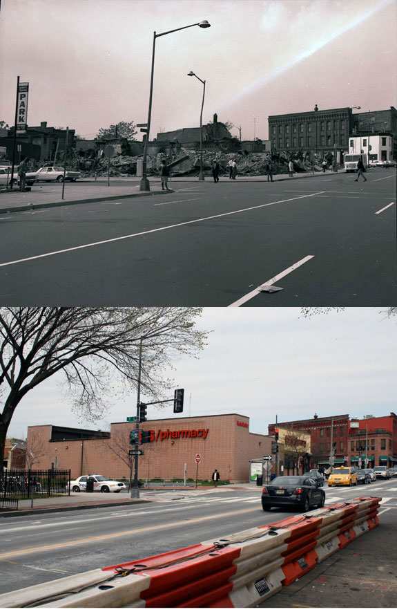
1968 riots at 7th & T Streets NW
This is the third in a series on the Scurlock photo archive. Read the others.
The 1968 riots burned and economically destroyed many commercial districts throughout Washington. Riots came to U Street, too, and several properties which were obliterated have not entirely recovered from the devastation.
After World War II, many of America’s cities faced population and economic decline as the nation suburbanized; Washington was certainly no exception. The retail corridors on 14th St NW, U St NW, and H St NE were already declining when riots hit American cities in 1968 following the Martin Luther King’s assassination.
Addison Scurlock (1883-1964) was Washington’s most prominent black photographer and when the riots started in April 1968, Mr. Scurlock[‘s sons, who inherited his studio] at 9th and U Streets (where Nellie’s now stands) knew that [they were]he was witnessing history in the making. Mr. Scurlock The Scurlocks photographed rioters at the beginning of the riots and photographed some of the aftermath.
The corner of 7th Street, Florida Avenue, and Georgia Avenue suffered from the mayhem. The southwest corner now houses a CVS and a parking lot on land that Howard University owns. Beneath this store runs the Metro tunnel between the Shaw and U Street stations. Back in 1968, this site featured a strip of retail stores until the riot.
One of the most striking Scurlock photos is of the northwest corner of 7th and T Streets NW, where the CVS currently stands. Rioters burned the buildings that stood on the site.
[Toggling between now and then photos will not work in RSS readers. View the actual post]
Should DC allow more angle parking on Sunday mornings?
Councilmember Harry Thomas, Jr. (D — Ward 5) introduced a bill to ease Sunday parking tensions by permitting angle parking for religious institutions with ANC and DDOT approval. The councilmember held a forum on the bill and its companion commercial district bill last week.
In DC neighborhoods where street parking is at a premium, few things raise a resident’s ire like church congregants who park illegally on Sunday mornings. Congregants who drive from other parts of the District, from Maryland, and from Virginia have been known to double-park, park in alleys, block crosswalks, and block fire hydrants.
After receiving numerous complaints from residents, Mr. Thomas introduced the bill to primarily allay residents in Bloomindale and Eckington. Since these neighborhoods are among Ward Five’s most densely populated, they, like LeDroit Park, suffer from high street parking occupancy. Last week in Eckington, Mr. Thomas hosted a forum on his bills and took questions from residents.
Mr. Thomas acknowledged what residents have long known: parking enforcement around churches is intentionally lax on Sundays. Though Mr. Thomas admitted the unique challenges to transportation on Sunday mornings, he also decried congregants who park illegally, block residents in, and hinder public safety.
Transit service reaches its nadir on Sunday mornings, and churchgoers often travel to churches in residential neighborhoods with light Sunday service. Since transit service and car traffic are relatively low on Sunday mornings, Mr. Thomas thinks DDOT will be able to find instances of roadways wide enough to accommodate both angle parking and through traffic on Sunday mornings. In each case, though, DDOT will make the final determination of what is safe and permitted, even if an ANC supports the petition.

Left: typical curbside parking. Right: possible angle parking
We asked Mr. Thomas why he singled out angle parking and not other non-traditional parking arrangements and he admitted that the bill was just a first draft and could be expanded to include other measures.
For instance, DDOT permits parking beside the median on Sundays on the 1300 and 1400 blocks of New York Avenue NW downtown. This arrangement works since there is still one lane available for through traffic and since Sunday morning traffic flows are small. A similar arrangement might work along other multi-lane avenues in the District, including Rhode Island Avenue.
In other cases, solutions could be less radical. The congregants of several churches on Florida Avenue park in the right lane on Sunday morning even where parking is never permitted at any time. DDOT may be able to simply change the signs and permit curbside parking in such places on Sunday mornings. The extra parking can act as a traffic-calming measure, though, as we know, easier parking can induce more driving.
No matter what happens, the Department of Public Works, the primary agency in charge of parking enforcement, needs to end its practice of lax Sunday enforcement near churches. Only DDOT, not pastors and not congregants, should make the determination as to what constitutes safe Sunday morning parking. Mr. Thomas acknowledged that the law needs to be enforced uniformly as it is unfair to overlook, as one resident noted, illegal parking in residential neighborhoods, while actively ticketing illegal parking downtown on Sundays.
Though residents expressed frustration with some, though not all, neighborhood churches, Mr. Thomas rightly advised residents that parking tensions need not be adversarial. In fact, he called attention to instances in which neighborhood residents and churches collaborated to resolve parking problems. This can include urging pastors to rent unused lots for their congregants or to provide shuttle service from satellite lots or from congregants’ homes. He even touted bikesharing several times but said it is not practical for everyone.
Whatever the solution, Mr. Thomas admitted the bill was in its infancy and that he wants to provide a template for cooperation; angle parking may be one of many possible solutions.
Mr. Thomas was eager to mention the companion bill to allow permanent angle parking in business districts. Though most meeting attendees were there to complain about church parking in residential neighborhoods, Mr. Thomas said that many Ward 5 businesses depend heavily on customers arriving by private car. However, when he asked a local business owner how much of his business is from outside his neighborhood, the owner said that very little came from elsewhere.
The business corridor bill is significantly different from the Sunday parking bill. The former would permit businesses to seek diagonal parking at all times, regardless of transit service, or if the street space could be reallocated to bike lanes or wider sidewalks.
The Sunday parking bill carries more merit than the business corridor bill because of the unique circumstances of church locations and Sunday transit service. The business corridor bill, in contrast, too hastily and disproportionately prioritizes parking to the detriment of other road uses.
Shaw’s Tavern, with apartments above, will open mid-June

Mr. Steve May relayed more details on Shaw’s Tavern at last night’s meeting of the LeDroit Park Civic Association. The restaurant, slated to open in mid-June, will seat 65 – 70 people inside and 15 – 18 people on a sidewalk patio on the 6th Street front. On Florida Avenue near the eastern end of the building, the restaurant will feature a special door just for take-out pizza orders. (Click the image above for a larger version.)
Inside, however, the restaurant will feature a variety of entrées priced from $12 – $18. Mr. May distributed a tentative menu.
The restaurant expects to stay open until 11:30 or midnight on weeknights and until midnight or 1 am on weekends.
As for the adjacent empty lot on 6th Street, Mr. May offered to buy it, but says the owner demanded $1 million, which is far too much for a vacant lot of that size.
While Shaw’s Tavern will occupy the first floor, the restaurant will rent out three one-bedroom apartments upstairs and expects to have them ready by May.
Shaw’s Tavern on its way
The building at the southeast corner of 6th Street and Florida Avenue (pictured above) may soon have a tenant. At Tuesday’s meeting of the LeDroit Park Civic Association, Mr. Steve May will discuss construction plans for a restaurant called Shaw’s Tavern. We don’t have the full details, but we are told it will be similar to Clarendon’s Liberty Tavern, which describes itself thusly:
Located in a historic building in the heart of Clarendon, The Liberty Tavern features modern American cuisine in its upstairs dining room and downstairs bar, along with a diverse wine list, creative specialty cocktails and a great selection of premium draft and bottled beer. Our comfortable ambiance is enhanced by warm, hospitable service, and whether you’re joining us for a round of drinks in the bar, a casual midweek supper with your children, or a special evening with friends and family, you’re sure to feel at home.
Attend the civic association meeting on Tuesday night for more details. (7 pm in the basement of the Florida Avenue Baptist Church; enter on U Street)


Recent Comments