Howard still owns a few properties in LeDroit Park
In reviewing Howard University’s proposed campus plan, we started to take account of all of the property in DC that the university owns. Up until 10 years ago, Howard University was accused of being LeDroit Park’s biggest slumlord, owning numerous properties in the neighborhood and letting them lie vacant, blighted, and decaying.
Under the reign of university president H. Patrick Swygert, Howard made a significant and commendable effort to rehab and sell many of its vacant properties in the neighborhood.
For instance, the university owned all but one house on 400 block of Oakdale Place. It let these houses lie vacant, blighted, and boarded up. Under Pres. Swygert, the university renovated the houses and sold them to employees. Today the 400 block of Oakdale Place is fully occupied and a new condo building is nearing completion on the western end.
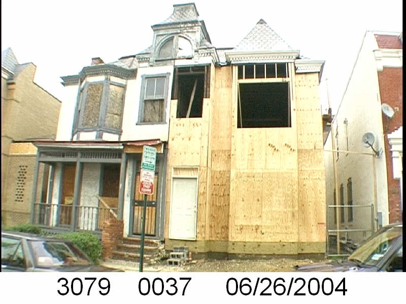
531 & 533 U St NW in 2004. Howard University renovated 531 (right) in 2004. Image from the DC government.
In other cases, the university renovated properties but has retained ownership. 531 U Street NW looked terrible in 2004 (right), but now looks very nice. We can’t quite tell if the house is occupied, but it consistently appears to be in good condition.
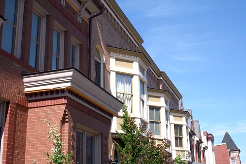
Elsewhere on the 500 and 600 blocks of U Street, Howard built historic infill houses (below) on vacant lots it owned on the north side of the street. The result is a block with with a continuous wall of housing on the street’s northern face. The houses’ façades are of high quality, with detailed brick work, ornate porches, and a variety of detailing.
The job is not entirely done, however, and Howard University retains ownership of a few properties that raise eyebrows. Let’s look at these three:
649 Florida Avenue (left) sits as a vacant lot, frequently collecting trash and debris. A university official told us that long ago Howard had considered using the lot to create a delightful pedestrian path to the university from the Shaw Metro. That never happened and now the lot sits vacant.
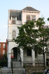
408-410 T Street (center) was the home of Walter Washington, DC’s first elected mayor. The university owns the property, and though it’s not blighted, it may be vacant. With some renovation work, this would make an excellent rental home for a Howard professor or anyone else for that matter.
326 T Street (right) is the Mary Church Terrell House, future home of the Robert and Mary Church Terrell House & LeDroit Park Museum and Cultural Center. Though it’s vacant and undoubtedly meets the District’s definition of blight, we are willing to cut the university more slack in this case since the eventual outcome will be a wonderful addition to the neighborhood. Unfortunately, the campus plan does not specify any additional Howard funding to restore the site.
In addition to the properties above, Howard owns a few more properties in LeDroit Park:
- Gravel parking lot at the SE corner of 5th and W Streets. (Square 3072, Lot 818). Campus plan does not mention any change to this lot.
- Carver Hall, 211 Elm St NW (Square 3084, Lot 830). Campus plan mentions the dorm’s decommission, but no reuse plans.
- Slowe Hall, 1919 3rd St NW (Square 3088, Lot 835). Campus plan mentions the dorm’s decommission, but no reuse plans.
- Howard University Hospital daycare, 1907-11 5th St NW (Square 3090, Lot 41)
- 420 T St NW – a house that appears to be occupied (Square 3094, Lot 800)
- Howard University Hospital (Square 3075, Lot 807)
- Parking garage bounded by 4th St, Oakdale Pl, 5th St, and V St. (Square 3080, Lot 73)
- Parking garage bounded by 4th St, V St, 5th St, and an alley. (Square 3072, Lot 52)
Though Howard retains a few problematic properties, it’s important to note the great strides the university has made in taking responsibility for its property portfolio in the neighborhood. A plan for these few remaining properties, even one in which the university retains ownership but leases, would put residents at greater ease.
Civic association conditions zoning support on vacancy
 At Tuesday night’s meeting of the LeDroit Park Civic Association, the association voted 11-2 to support the Howard University Campus Plan. Since several issues in the plan remain unresolved and unspecified, your author voted against supporting it.
Among many concerns are the several vacant properties that Howard University owns in the area. Though Howard has made a commendable effort to refurbish and sell many of these properties in LeDroit Park over the past decade, we are worried that the university, after it moves students out of Slowe and Carver Halls might leave these two dormitories vacant for several years.
The university has been very adept at finding excuses for keeping several of its properties vacant in decades past.
For current vagueness in the plan, university officials say they haven’t determined a use yet or that they haven’t found the financing or that everything is the economy’s fault.
That may be true, but vacant buildings attract trouble. They become safe-havens for criminals, vagrants, and rodents. Some vacant properties become truly blighted with windows covered up with plywood or metal covers. This blight drags down property values and lowers the quality of life.
For most private property owners, vacant properties (class 3) face a steep 5% annual property tax and blighted buildings (class 4) face a 10% annual property tax. These punitive tax rates are meant to urge owners of vacant and blighted properties to return their properties to good order and productive use.
As a university, however, Howard pays no taxes on its land, so a punitive 5% or 10% tax on $0 is still $0 . As such, the neighborhood needs a legal mechanism to ensure the university does not vacate Slowe and Carver Halls and then blame the economy as they board up the buildings for several years.
Whether the university keeps the buildings as student dorms or converts them to faculty housing is fine either way, but vacancy and blight threatens the progress the neighborhood has made over the past decade.
To prevent this, your author moved “To amend our support [for the campus plan] to prohibit vacancy of Slowe and Carver Halls for more than one year.”
The motion was property seconded and passed unanimously.
The civic association will submit this language to the Zoning Commission and urge the commission to attach it to the legally enforceable order that ratifies the campus plan. This will ensure that these two large dormitories do not sit vacant for an unreasonable length of time over the next decade.
Howard University’s campus plan is an ambitious and mostly good plan, but it’s important that point out its shortcomings and to ensure the university does not get away with undue burdens on neighborhoods and the District.
Exemption from property taxes is a privilege, not a right, and residents are wise to ensure this exemption is not abused to the detriment of the public interest.
Census data for LeDroit Park
In preparation for redistricting Ward 1’s ANCs, the DC Office of Planning has released block-by-block demographic data for the District. We have combined the data for the blocks that comprise LeDroit Park to create a LeDroit Park census.
Analyzing U.S. Census data for LeDroit Park proves difficult because the of the way census tracts are drawn. Our census tract, 34, combines LeDroit Park and Howard University. Dorms on the northern end of the campus, far away from LeDroit Park, account for 717 of the tract’s 4,347 residents, thus skewing tract data. Furthermore, the tract also inclues several blocks bounded by Rhode Island Avenue NW, Florida Avenue NW, and 2nd Street NW.
Fortunately, the Census Bureau provides data for each block, allowing us to combine the statistics for those blocks in LeDroit Park, while excluding the Howard University campus. In the map below, we have outlined the tract in blue and shaded the blocks for LeDroit Park in red.
View LeDroit Park Census in a larger map
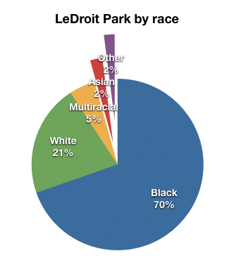
Though LeDroit Park started out as an exclusively white suburban neighborhood, by 1910 the neighborhood was almost entirely black. Today, 100 years later, the neighborhood is 70% black and is continuing to diversify.
However, when looking at the numbers on a block-by-block basis, you see that the neighborhood demography, must like that of the District itself, is unevenly distributed.
The block bounded by 5th Street, T Street, 6th Street, and U Street is 53% white, the highest in the neighborhood. Likewise, the block containing the Kelly Miller public housing is 91% black, the highest percentage in the neighborhood. The block containing the arch and the Florida Avenue Baptist Church comes closest to black-white equilibrium at 44% and 49% for each group respectively.
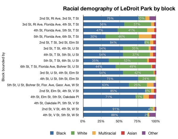
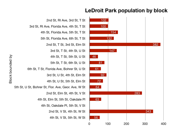
When looking at total population numbers for each block, you see that the two most populous blocks contain Howard University dorms. The block bounded by 2nd Street, T Street, 3rd Street, and Elm Street has 382 residents and contains Slowe Hall, which houses 299 students.
The second most populous block contains the new park. However, it also contains Carver Hall, which itself houses 173 students. Certainly these blocks are big, but the fact that their population numbers are off the chart has more to do with student dorms than with any inherent difference in housing density.
Finally, when we look at housing vacancy, we see that the block bounded by 5th Street, T Street, 6th Street and U Street has 38% of its housing units vacant. We’re not sure what’s causing this number, but we suspect that the apartment building at 5th and U Streets NW boosted the vacancy rate. The building has since been finished and is fully rented.
The block with the second-highest rate of vacancy contains the now-renovated Ledroit Place condo building at 1907 3rd Street NW.
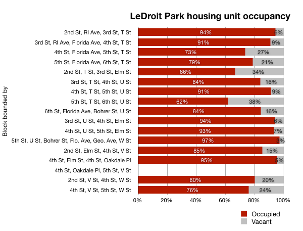
It would be interesting too look at other data, including household income, car ownership, and age distribution for the neighborhood. However, the Office of Planning’s spreadsheet only covered population numbers, racial distribution, and housing unit numbers, so those are the metrics we graphed.




Recent Comments